File:I08 606 Barranco Rey Magdaletín.jpg

Size of this preview: 800 × 533 pixels. Other resolutions: 320 × 213 pixels | 640 × 427 pixels | 1,024 × 683 pixels | 1,280 × 853 pixels | 2,560 × 1,707 pixels | 4,494 × 2,996 pixels.
Original file (4,494 × 2,996 pixels, file size: 6.42 MB, MIME type: image/jpeg)
Captions
Captions
Add a one-line explanation of what this file represents
Summary edit
| Description |
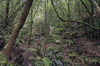
Deutsch: Über der Nordküste von La Palma im kanarischen Lorbeerwald, durch den Barranco verläuft der Wanderweg LP PR 9.2 La Zarza. Er beginnt an der Ringstraße LP-1 unmittelbar vor dem Eingang zum Besucherzentrum der Benhoaritafundstelle La Zarza. Im Talgrund liegen drei Abbruchstufen. |
| Date | |
| Source | Own work |
| Author | Falk2 |
Licensing edit
This file is licensed under the Creative Commons Attribution-Share Alike 4.0 International license.
- You are free:
- to share – to copy, distribute and transmit the work
- to remix – to adapt the work
- Under the following conditions:
- attribution – You must give appropriate credit, provide a link to the license, and indicate if changes were made. You may do so in any reasonable manner, but not in any way that suggests the licensor endorses you or your use.
- share alike – If you remix, transform, or build upon the material, you must distribute your contributions under the same or compatible license as the original.
Original upload log edit
Transferred from de.wikipedia to Commons by Wdwdbot using script bot_filetrans.pl (r121M).
The original description page was here. All following user names refer to de.wikipedia.
- 2021-10-04 19:58:02 Falk2 (6733071 Bytes)
File history
Click on a date/time to view the file as it appeared at that time.
| Date/Time | Thumbnail | Dimensions | User | Comment | |
|---|---|---|---|---|---|
| current | 23:44, 18 October 2021 | | 4,494 × 2,996 (6.42 MB) | Wdwdbot (talk | contribs) | Bot Move: Original uploader of this revision (#1) was Falk2 at de.wikipedia |
You cannot overwrite this file.
File usage on Commons
The following page uses this file: