File:IAN 0105 Salamanca 1540 Preveza.jpg

Size of this preview: 800 × 565 pixels. Other resolutions: 320 × 226 pixels | 640 × 452 pixels | 1,024 × 723 pixels | 1,299 × 917 pixels.
Original file (1,299 × 917 pixels, file size: 977 KB, MIME type: image/jpeg)
Captions
Captions
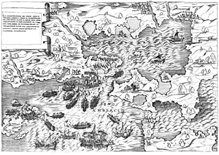
View of the Sea battle of Preveza, 1538, and the castle of Bouka, Preveza.
Summary edit
| Title |
Italiano: La dimostratione del luogo dove al presene sitrova l' armat di Barbarossa, et de Christiani detto il golfo dell' Artha antichamente il seno Ambracio, da Ambracia citta reale di Pylrrho, vicino al promontorio Actio per la victoria di Avgvsto contr' a Marc' Antonio et Cleopatra, memorabile.. English: The sea battle of Preveza, 1538. Ελληνικά: Η ναυμαχία της Πρέβεζας του 1538. |
|||||||||||||||||||||||
| Description |
English: View of the Sea battle of Preveza, 1538, and the castle of Bouka, Preveza. Copper engraving by Antonio Salamanca, 1540 c. Nikos D. Karabelas map collection, Actia Nicopolis Foundation, Preveza, Greece. Ελληνικά: Απεικόνιση της ναυμαχίας της Πρέβεζας, 1538, και του κάστρου της Μπούκας στην Πρέβεζα. Χαλκογραφία του Antonio Salamanca του 1540 περίπου. Συλλογή χαρτών Νίκου Δ. Καράμπελα, Ίδρυμα Ακτία Νικόπολις, Πρέβεζα |
|||||||||||||||||||||||
| Date | circa 1540 | |||||||||||||||||||||||
| Source | In Charta. Prints of Preveza, Preveza 2006, Map no. 1 | |||||||||||||||||||||||
| Creator |
Antonio Salamanca (1479-1562) |
|||||||||||||||||||||||
| Permission (Reusing this file) |
This file is licensed under the Creative Commons Attribution 4.0 International license.
| |||||||||||||||||||||||
| Attribution (required by the license) | ||||||||||||||||||||||||
| Geotemporal data | ||||||||||||||||||||||||
| Date depicted | September 1538, during the sea battle of Preveza. | |||||||||||||||||||||||
| Map location | Preveza, Greece | |||||||||||||||||||||||
| Map type | nautical chart | |||||||||||||||||||||||
| Heading |
 |
|||||||||||||||||||||||
| Bounding box |
|
|||||||||||||||||||||||
| Georeferencing | If inappropriate please set warp_status = skip to hide. | |||||||||||||||||||||||
| Bibliographic data | ||||||||||||||||||||||||
| Part of the series |
English: Actia Nicopolis Foundation, Preveza, Greece. Nikos D. Karabelas map collection. Ελληνικά: Ίδρυμα Ακτία Νικόπολις, Πρέβεζα. Συλλογή χαρτών Νίκου Δ. Καράμπελα. |
|||||||||||||||||||||||
| Map sheet | IAN 0105 | |||||||||||||||||||||||
| Language | Italian | |||||||||||||||||||||||
| Archival data | ||||||||||||||||||||||||
| Collection |
|
|||||||||||||||||||||||
| Accession number |
IAN_0105 |
|||||||||||||||||||||||
| Dimensions | height: 300 mm (11.81 in); width: 433 mm (17.04 in) | |||||||||||||||||||||||
| Medium |
English: Copper engraving. Ελληνικά: Χαλκογραφία. |
|||||||||||||||||||||||
| Inscriptions | Golfo del' Artha / Seno Ambracio / Prevessa / Vathi / S. Georgio / S. Basilio / Basislo / S. Nicolo / Tempio d' Apolline / Rignassa / Porto Fanaro / Parga / Paxv / Anti Paxv / Rogiaco / S. Mavra / Levcadia | |||||||||||||||||||||||

- Error in {{Map}} template: unknown parameter "1", "2", "3", "4", "5", "6", "7", "8".
File history
Click on a date/time to view the file as it appeared at that time.
| Date/Time | Thumbnail | Dimensions | User | Comment | |
|---|---|---|---|---|---|
| current | 17:08, 23 November 2015 | | 1,299 × 917 (977 KB) | Actia Nicopolis (talk | contribs) | {{Map | accession number = IAN_0105 | author = Antonio Salamanca (1479-1562) | date = 1540 c. | demo = | title = La dimostratione del luogo dove al presene sitrova l' armat di Barbarossa, et de Christiani detto il golfo dell' Artha antichamente i... |
You cannot overwrite this file.
File usage on Commons
The following 3 pages use this file:
- File:IAN 0105.jpg (file redirect)
- File:Salamanca Preveza.jpg (file redirect)
- File:The sea battle of Preveza.jpg (file redirect)
File usage on other wikis
The following other wikis use this file:
- Usage on el.wikipedia.org
- Usage on en.wikipedia.org
- Usage on es.wikipedia.org
- Usage on pt.wikipedia.org
- Usage on sr.wikipedia.org
- Usage on vi.wikipedia.org