File:IAN 0208.jpg
Size of this preview: 800 × 540 pixels. Other resolutions: 320 × 216 pixels | 640 × 432 pixels | 1,024 × 692 pixels | 1,280 × 865 pixels | 2,560 × 1,729 pixels | 5,130 × 3,465 pixels.
Original file (5,130 × 3,465 pixels, file size: 14.74 MB, MIME type: image/jpeg)
Captions
Captions
Add a one-line explanation of what this file represents
Summary
edit
| Title |
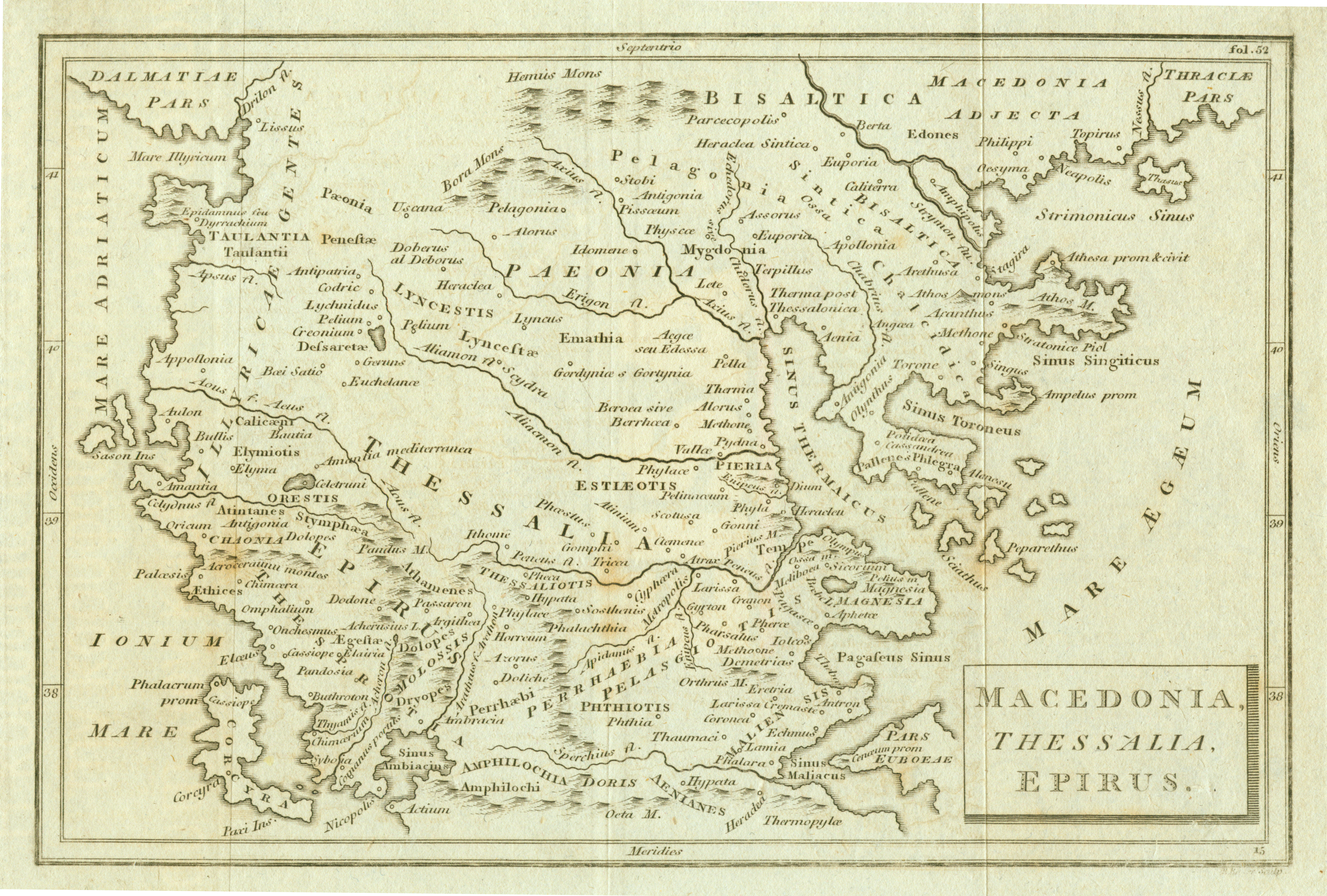
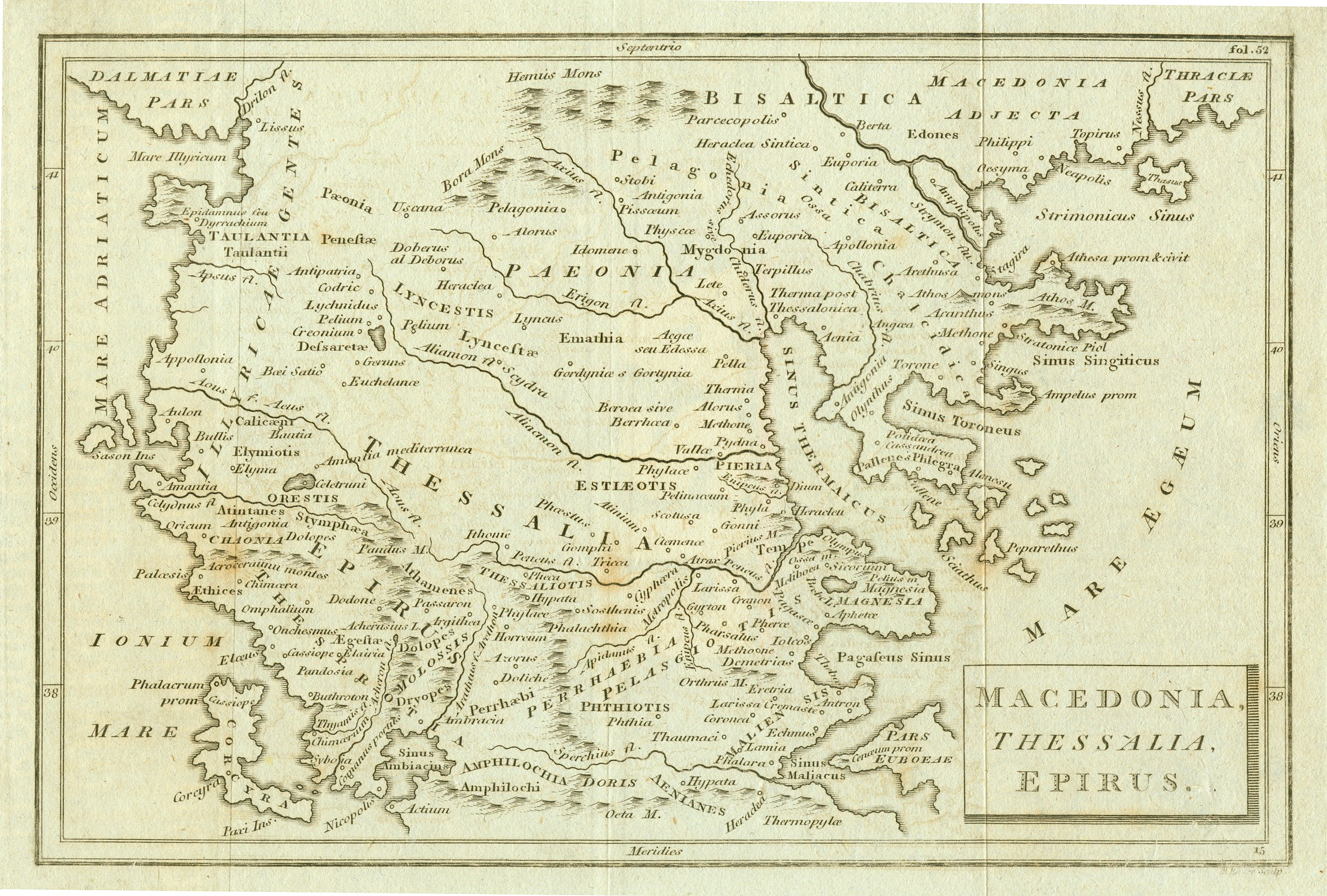
Italiano: Macedonia, Thessalia, Epirus. |
|||||||||||||||||||||||
| Permission (Reusing this file) |
This file is licensed under the Creative Commons Attribution 4.0 International license.
| |||||||||||||||||||||||
| Attribution (required by the license) | ||||||||||||||||||||||||
| Geotemporal data | ||||||||||||||||||||||||
| Map type | map | |||||||||||||||||||||||
| Spatial reference system | Mercator | |||||||||||||||||||||||
| Heading |
 |
|||||||||||||||||||||||
| Georeferencing | If inappropriate please set warp_status = skip to hide. | |||||||||||||||||||||||
| Bibliographic data | ||||||||||||||||||||||||
| Part of the series |
English: Actia Nicopolis Foundation, Preveza, Greece. Nikos D. Karabelas map collection. Ελληνικά: Ίδρυμα Ακτία Νικόπολις, Πρέβεζα. Συλλογή χαρτών Νίκου Δ. Καράμπελα. |
|||||||||||||||||||||||
| Map sheet | IAN 0208 | |||||||||||||||||||||||
| Archival data | ||||||||||||||||||||||||
| Collection |
|
|||||||||||||||||||||||
| Accession number |
IAN_0208 |
|||||||||||||||||||||||
| Medium |
English: Copper engraving. Ελληνικά: Χαλκογραφία. |
|||||||||||||||||||||||
File history
Click on a date/time to view the file as it appeared at that time.
| Date/Time | Thumbnail | Dimensions | User | Comment | |
|---|---|---|---|---|---|
| current | 08:50, 11 August 2021 | | 5,130 × 3,465 (14.74 MB) | Actia Nicopolis (talk | contribs) | == {{int:filedesc}} == {{Map | title = {{it|1='''Macedonia, Thessalia, Epirus.'''}} | wikidata title = | description = | legend = | author = | imgen = | date = | source = | permission = {{Template:Cc-by-4.0}} | map date = | location = | wikidata location = | projection = Mercator | scale = | heading = 360 | latitude = | longitude = | warped = | set = {{en|1=Actia Nicopolis Foundation, Preveza, Greece. Nikos D. Karabelas map collection.}}{{el|1=Ίδρυμα ''Ακτία Ν... |
You cannot overwrite this file.
File usage on Commons
There are no pages that use this file.