File:IS-B Komar 49 'SP-985' (15813428839).jpg

Original file (3,734 × 3,607 pixels, file size: 10.83 MB, MIME type: image/jpeg)
Captions
Captions
Summary edit
.jpg&action=edit§ion=1)
| Description |
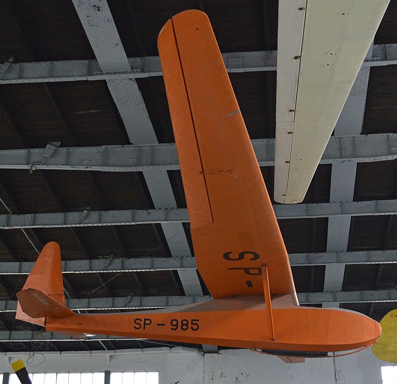
c/n 144P. On display suspended in the main display hangar at the Muzeum Lotnictwa Polskiego Krakow, Poland. 23-08-2013. The following info is taken from the museum website:- "This is a single seater training glider of wooden construction in the strutted upper wing configuration. In 1933, Antoni Kocjan designed and built the "Komar" (gnat) glider, and in 1937, its improved version the "Komar-bis" of increased rigidity. 67 gliders were built until the outbreak of the Second World War. They served for training and for performance flights. Fifteen domestic records were established on "Komars". In 1937, the Polish pilot Wanda Modlibowska established the world record of flight duration - 24 hrs and 14 min. The "Komars" were built on licence in Bulgaria, Estland, Finland, France, Palestine, Romania and Yugoslavia (where seven domestic records were established on this gliders). In 1947, at the Gliding Institute, engineer Marian Wasilewski basing on the original drawings of the glider, modified its construction to an actual at that time demands. The first flight of the new "Komar" took place on 16th January 1948. The five examples, built in that year bore the Komar 48 designation. The next batch of 18 examples was produced under the "Komar 49" name. The gliders had a very good opinion among pilots and were in service with aeroclubs until 1965. Flying the SP-732 "Komar 48" on 19-20 October 1949, the Polish pilot Stanisław Wielgus established the world record flight duration, lasting 35 hrs 14 min. The displayed at the museum, the SP-985 "Komar 49" glider, was produced at the Jeżów Glider Workshop . Next, it was used at the Szczecin Aeroclub and the Glider School at the Żar hill." |
| Date | |
| Source | IS-B Komar 49 'SP-985' |
| Author | Alan Wilson from Stilton, Peterborough, Cambs, UK |
| Camera location | | View this and other nearby images on: OpenStreetMap |
|---|
.jpg¶ms=050.077096_N_0019.992209_E_globe:Earth_type:camera_source:Flickr_&language=en)
Licensing edit
.jpg&action=edit§ion=2)
- You are free:
- to share – to copy, distribute and transmit the work
- to remix – to adapt the work
- Under the following conditions:
- attribution – You must give appropriate credit, provide a link to the license, and indicate if changes were made. You may do so in any reasonable manner, but not in any way that suggests the licensor endorses you or your use.
- share alike – If you remix, transform, or build upon the material, you must distribute your contributions under the same or compatible license as the original.
| This image was originally posted to Flickr by Hawkeye UK at https://flickr.com/photos/65001151@N03/15813428839 (archive). It was reviewed on 20 August 2018 by FlickreviewR 2 and was confirmed to be licensed under the terms of the cc-by-sa-2.0. |
File history
Click on a date/time to view the file as it appeared at that time.
| Date/Time | Thumbnail | Dimensions | User | Comment | |
|---|---|---|---|---|---|
| current | 00:28, 20 August 2018 | | 3,734 × 3,607 (10.83 MB) | William Graham (talk | contribs) | Transferred from Flickr via #flickr2commons |
You cannot overwrite this file.
File usage on Commons
The following 2 pages use this file:
File usage on other wikis
The following other wikis use this file:
- Usage on en.wikipedia.org
- Usage on pl.wikipedia.org
- Usage on sr.wikipedia.org
- Usage on tg.wikipedia.org
- Usage on www.wikidata.org
.jpg&oldid=855995148)