File:ISS008-E-6474 - View of Cuba - Nipe Bay, Mayarí, Antilla (Holguín province).jpg
Original file (3,032 × 2,064 pixels, file size: 887 KB, MIME type: image/jpeg)
Captions
Captions
Summary
edit.jpg&action=edit§ion=1)
| Description |
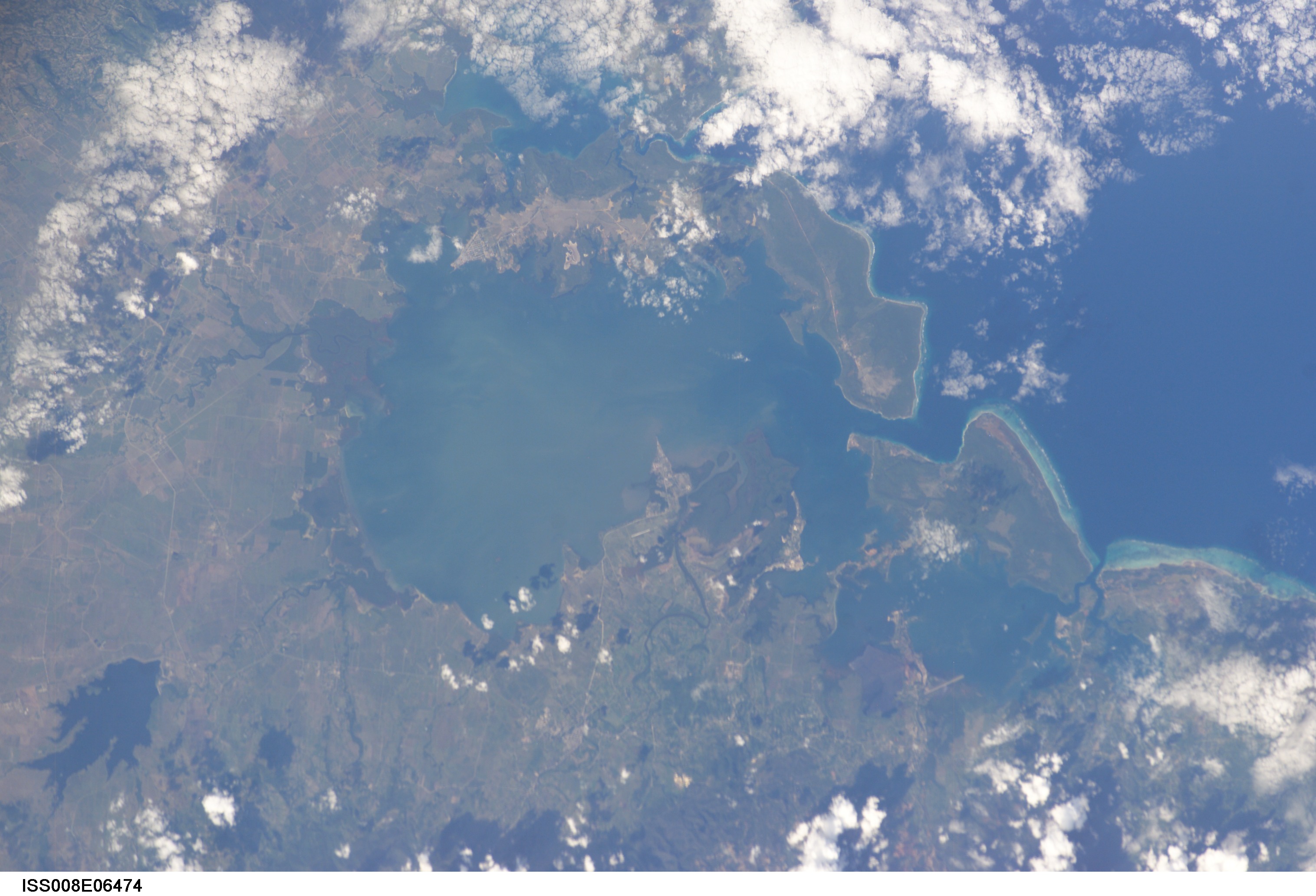
English: View of Cuba taken during ISS Expedition 8. Holguín Province, about 140 km from the East point of Cuba: Nipe bay (Spanish: Bahía de Nipe), municipalities of Mayarí (to the south) and Antilla (to the north). Also shows Cajimaya bay (east of Nipe bay) and Levisa bay (south-east of Cajimaya bay), with Cabonico bay on its east side (rather indistinct here). Cabonico bay uses the same outlet to the sea as Levisa bay an that outlet is very clear in this picture as a double-pronged fork. This shows the village of Guatemala (south side, with a point sticking out in the bay) just left (west) of the Mayarí river, and Felton on the right (east) of that river.
Mayarí is just south of Guatemala and Antilla in on the north shore. |
| Date | |
| Source | JSC Gateway to Astronaut Photography of Earth |
| Author | Earth Science and Remote Sensing Unit, Lyndon B. Johnson Space Center |
| Mission | ISS008 |
| Roll | E |
| Frame | 6474 |
| Geographic area | Cuba |
| Features | BAY OF NIPE, ANTILLA, REEFS |
| Cloud percentage | 25% |
| Altitude | 202 nautical miles (374 km) |
| Look angle | 36 |
| Look direction | NE |
| Sun Azimuth | 222° |
| Sun Elevation | 36° |
| Camera | Kodak DCS760c Electronic Still Camera |
| Focal length | 200 mm |
| Camera location | | View this and other nearby images on: OpenStreetMap |
|---|
.jpg¶ms=019.400000_N_-077.300000_E_globe:Earth_type:camera__&language=en)
| Object location | | View this and other nearby images on: OpenStreetMap |
|---|
.jpg¶ms=021.000000_N_-075.500000_E_globe:Earth_class:object_type:object__&language=en)
This image or video was catalogued by Johnson Space Center of the United States National Aeronautics and Space Administration (NASA) under Photo ID: ISS008-E-6474. This tag does not indicate the copyright status of the attached work. A normal copyright tag is still required. See Commons:Licensing. Other languages:
|
Licensing
edit.jpg&action=edit§ion=2)
| This file is in the public domain in the United States because it was solely created by NASA. NASA copyright policy states that "NASA material is not protected by copyright unless noted". (See Template:PD-USGov, NASA copyright policy page or JPL Image Use Policy.) | ||
 |
Warnings:
|
File history
Click on a date/time to view the file as it appeared at that time.
| Date/Time | Thumbnail | Dimensions | User | Comment | |
|---|---|---|---|---|---|
| current | 06:07, 22 September 2022 | | 3,032 × 2,064 (887 KB) | AskeBot (talk | contribs) |
You cannot overwrite this file.
File usage on Commons
The following page uses this file:
- File:ISS008-E-6474 - View of Cuba.jpg (file redirect)
.jpg&oldid=829594426)