File:Iberia Bronze-es.svg

Size of this PNG preview of this SVG file: 727 × 600 pixels. Other resolutions: 291 × 240 pixels | 582 × 480 pixels | 931 × 768 pixels | 1,242 × 1,024 pixels | 2,484 × 2,048 pixels | 924 × 762 pixels.
Original file (SVG file, nominally 924 × 762 pixels, file size: 190 KB)
Captions
Captions
Add a one-line explanation of what this file represents
Summary
edit| Description |
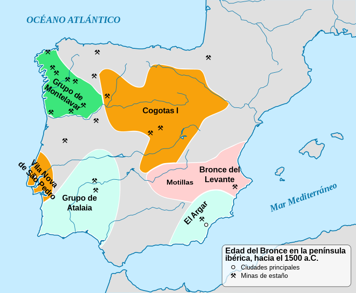
English: Map of Iberian Middle Bronze Age c. 1500 BCE, showing the main cultures, the two main cities and the location of strategic tin mines. VNSP stands for Vila Nova de São Pedro. Español: La Edad del Bronce en la península ibérica hacia el 1500 a. C. |
| Date | |
| Source | |
| Author |
|
| Other versions |
|


Licensing
edit
I, the copyright holder of this work, hereby publish it under the following license:
This file is licensed under the Creative Commons Attribution-Share Alike 3.0 Unported license.
- You are free:
- to share – to copy, distribute and transmit the work
- to remix – to adapt the work
- Under the following conditions:
- attribution – You must give appropriate credit, provide a link to the license, and indicate if changes were made. You may do so in any reasonable manner, but not in any way that suggests the licensor endorses you or your use.
- share alike – If you remix, transform, or build upon the material, you must distribute your contributions under the same or compatible license as the original.
File history
Click on a date/time to view the file as it appeared at that time.
| Date/Time | Thumbnail | Dimensions | User | Comment | |
|---|---|---|---|---|---|
| current | 06:55, 2 June 2016 | | 924 × 762 (190 KB) | Rowanwindwhistler (talk | contribs) | Minor errors corrected Colours from https://en.wikipedia.org/wiki/Wikipedia:WikiProject_Maps/Conventions White borders Black text (better contrast) |
| 22:32, 14 March 2014 |  | 924 × 762 (190 KB) | Rowanwindwhistler (talk | contribs) | VLSP expanded | |
| 22:31, 14 March 2014 |  | 924 × 762 (190 KB) | Rowanwindwhistler (talk | contribs) | User created page with UploadWizard |
You cannot overwrite this file.
File usage on Commons
The following 2 pages use this file:
File usage on other wikis
The following other wikis use this file:
- Usage on de.wikipedia.org
- Usage on es.wikipedia.org
- Edad del Bronce
- Prehistoria en la península ibérica
- El Argar
- Cultura argárica
- Cerro de Las Viñas
- Bronce Manchego
- Cerro del Nacimiento
- Carpetanos
- Historia de Villarrobledo
- Hombre de Galera
- El Rincón de Almendricos
- El Oficio
- Cerro de la Encina
- Ifre
- Cuesta del Negro
- Gatas (yacimiento arqueológico)
- Anexo:Cronología de la prehistoria de la península ibérica
- Usage on fr.wikipedia.org
- Usage on it.wikipedia.org