File:Ibiza—Balàfia 004.jpg

Original file (1,000 × 681 pixels, file size: 758 KB, MIME type: image/jpeg)
Captions
Captions
Summary edit
| Description |
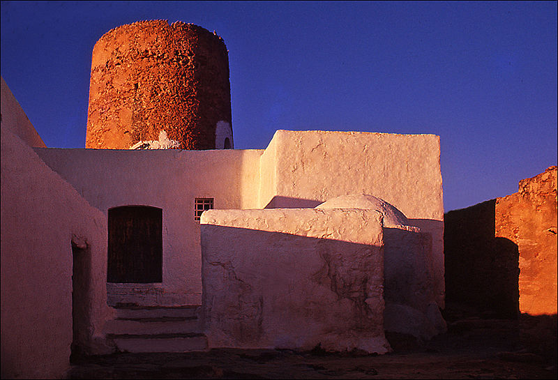
English: Located not far from the church of Sant Llorenç de Balàfia (18th century), Balàfia is a small hamlet that was built during Moorish times. It is still inhabited. People maintain the tradition of painting white symbols on the defense tower, but I'm not sure that this tradition comes all the way from the Middle Ages.
Please, read carefully the sections below: Author, Permission, and Attribution. |
| Date | |
| Source | Own work |
| Author |
Nicolas G. Mertens. This picture is not in the public domain. If you want to use this picture outside of Wikipedia, please read the Licensing section just below. In particular, "You must give appropriate credit, provide a link to the license, and indicate if changes were made. You may do so in any reasonable manner, but not in any way that suggests the licensor endorses you or your use." Esta imagen no es de dominio público. Si desea utilizar esta imagen fuera de Wikipedia, lea la sección Licencias justo debajo. En particular, "Debe dar el crédito apropiado, proporcionar un enlace a la licencia e indicar si se realizaron cambios. Puede hacerlo de cualquier manera razonable, pero no de ninguna manera que sugiera que el licenciante lo respalda a usted o su uso." |
| Permission (Reusing this file) |
You may use this photo outside of Wikipedia if and only if you provide proper credit to the author (Nicolas G. Mertens) under the terms of https://creativecommons.org/licenses/by-sa/4.0/deed.en, as indicated below in Attribution. Puede usar esta foto fuera de Wikipedia si y solo si proporciona el crédito adecuado al autor ( Nicolas G. Mertens) según los términos de https://creativecommons.org/licenses/by-sa/4.0/deed.en, como se indica a continuación en Atribución. |
| Attribution (required by the license) | © Nicolas G. Mertens / Wikimedia Commons / |
| Camera location | | View this and other nearby images on: OpenStreetMap |
|---|
Licensing edit
- You are free:
- to share – to copy, distribute and transmit the work
- to remix – to adapt the work
- Under the following conditions:
- attribution – You must give appropriate credit, provide a link to the license, and indicate if changes were made. You may do so in any reasonable manner, but not in any way that suggests the licensor endorses you or your use.
- share alike – If you remix, transform, or build upon the material, you must distribute your contributions under the same or compatible license as the original.
File history
Click on a date/time to view the file as it appeared at that time.
| Date/Time | Thumbnail | Dimensions | User | Comment | |
|---|---|---|---|---|---|
| current | 09:21, 9 August 2015 | | 1,000 × 681 (758 KB) | Nicolas G. Mertens (talk | contribs) | User created page with UploadWizard |
You cannot overwrite this file.
File usage on Commons
The following page uses this file: