File:Ice melt on Yana Bay, northern Russia (MODIS 2019-06-22).jpg

Original file (2,370 × 1,738 pixels, file size: 1,009 KB, MIME type: image/jpeg)
Captions
Captions
Summary
edit.jpg&action=edit§ion=1)
| Description |
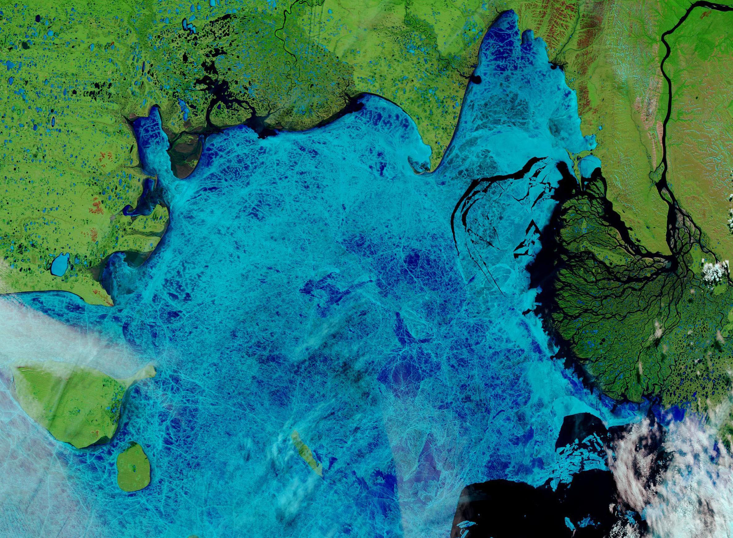
English: With temperatures soaring across much of Siberia and the Arctic Ocean, vigorous ice melt occurred early in the spring of 2019. Arctic sea ice maximum extent was reported as the seventh-lowest on record in March. By April the National Snow and Ice Data Center reported a new Arctic low sea ice extent for the month thanks to rapid melting. At the end of May, slower-than-average ice loss in the Barents Sea allowed Arctic sea ice daily extent to slightly improve to reach the second lowest in the 40-year satellite record.
Warm weather continued in much of the Arctic in June, including far northern Russia. According to Accuweather, temperatures at Tiksi airport, located in the Sakha Republic (Yakutia), the daily high temperature from June 1 through 21 was 15°F higher than average each day, except for just one day ticking only 10°F above average. Eleven days were above 80°F, with 3 days hitting 85°F on days when average highs ranged from 44-53°F. On June 19, 2019, the Moderate Resolution Imaging Spectroradiometer (MODIS) on board NASA’s Terra satellite acquired a stunning false-color image of melting ice in Yana Bay, off the northern coast of Russia’s Sakha Republic (Yakutia). In this image, ice appears bright blue, cloud appears white, open water appears black and vegetation appears bright green. North is at the bottom of the image, with the massive Lena River Delta in the west (right side of the image) and the Yana River flowing into Yana Bay in the east (left side of the river). Tiksi is located to the east of the Lena River Delta. Open, ice-free water can be seen north of the Lena River Delta and along much of the coast, while the Delta itself appears dark green, suggesting heavy plant growth. Large fissures in the ice pack show open water, while the white lines in the blue ice are stress marks, where the ice shifts and pushes together as it rides the moving ocean waves. Many of the thermokarst lakes that pock-mark the landscape are ice-free but many remain frozen. |
||
| Date | Taken on 19 June 2019 | ||
| Source |
Ice melt on Yana Bay, northern Russia (direct link)
|
||
| Author | MODIS Land Rapid Response Team, NASA GSFC |
| This media is a product of the Terra mission Credit and attribution belongs to the mission team, if not already specified in the "author" row |
Licensing
edit.jpg&action=edit§ion=2)
| This file is in the public domain in the United States because it was solely created by NASA. NASA copyright policy states that "NASA material is not protected by copyright unless noted". (See Template:PD-USGov, NASA copyright policy page or JPL Image Use Policy.) | ||
 |
Warnings:
|
File history
Click on a date/time to view the file as it appeared at that time.
| Date/Time | Thumbnail | Dimensions | User | Comment | |
|---|---|---|---|---|---|
| current | 03:15, 17 February 2024 | | 2,370 × 1,738 (1,009 KB) | OptimusPrimeBot (talk | contribs) | #Spacemedia - Upload of http://modis.gsfc.nasa.gov/gallery/images/image06222019_250m.jpg via Commons:Spacemedia |
You cannot overwrite this file.
File usage on Commons
There are no pages that use this file.
.jpg&oldid=852756240)