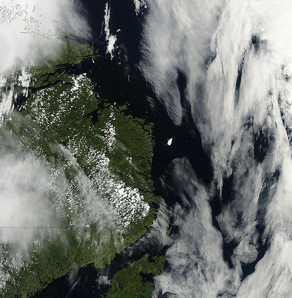
File:Iceberg PII-A off the coast of Newfoundland - Flickr - NASA Goddard Photo and Video.jpg

Original file (1,884 × 1,918 pixels, file size: 575 KB, MIME type: image/jpeg)
Captions
Captions
Summary edit
| DescriptionIceberg PII-A off the coast of Newfoundland - Flickr - NASA Goddard Photo and Video.jpg |
NASA image acquired July 20, 2011 In August 2010, the Petermann Glacier along the northwestern coast of Greenland calved an ice island roughly four times the size of Manhattan. Nearly a year later, on July 20, 2011, a piece of that ice island—named Petermann Ice Island-A (PII-A) and about the same size as Manhattan—was still visible to the Moderate Resolution Imaging Spectroradiometer (MODIS) on NASA’s Terra satellite. The Canadian Ice Service (CIS) tracked the ice island as it drifted through the Labrador Sea. On July 8, 2011, the CIS reported that the PII-A was approximately 55 square kilometers (21 square miles), and was continuing to lose surface area through calving and melting. On July 20, MODIS observed PII-A slightly south of where it had been a month earlier. On July 21, 2011, MSNBC reported that PII-A was slowly drifting toward Newfoundland. The glacier was not likely to reach land; its base would probably become grounded on the sea floor off the coast. The ice chunk did, however, pose a potential hazard for shipping lanes and offshore oil rigs.
Check out a video of this iceberg here: www.youtube.com/watch?v=VReyKfti_38&feature=player_em... NASA Goddard Space Flight Center enables NASA’s mission through four scientific endeavors: Earth Science, Heliophysics, Solar System Exploration, and Astrophysics. Goddard plays a leading role in NASA’s accomplishments by contributing compelling scientific knowledge to advance the Agency’s mission. Follow us on Twitter Like us on Facebook Find us on Instagram |
| Date | |
| Source | Iceberg PII-A off the coast of Newfoundland |
| Author | NASA Goddard Space Flight Center from Greenbelt, MD, USA |
Licensing edit
- You are free:
- to share – to copy, distribute and transmit the work
- to remix – to adapt the work
- Under the following conditions:
- attribution – You must give appropriate credit, provide a link to the license, and indicate if changes were made. You may do so in any reasonable manner, but not in any way that suggests the licensor endorses you or your use.
| This image was originally posted to Flickr by NASA Goddard Photo and Video at https://www.flickr.com/photos/24662369@N07/5974587546. It was reviewed on 17 August 2012 by FlickreviewR and was confirmed to be licensed under the terms of the cc-by-2.0. |
17 August 2012
| Public domainPublic domainfalsefalse |
| This file is in the public domain in the United States because it was solely created by NASA. NASA copyright policy states that "NASA material is not protected by copyright unless noted". (See Template:PD-USGov, NASA copyright policy page or JPL Image Use Policy.) |  | |
 |
Warnings:
|
File history
Click on a date/time to view the file as it appeared at that time.
| Date/Time | Thumbnail | Dimensions | User | Comment | |
|---|---|---|---|---|---|
| current | 20:59, 17 August 2012 |  | 1,884 × 1,918 (575 KB) | Werieth (talk | contribs) | == {{int:filedesc}} == {{Information |Description=NASA image acquired July 20, 2011 In August 2010, the Petermann Glacier along the northwestern coast of Greenland calved an ice island roughly four times the size of Manhattan. Nearly a year later, on... |
You cannot overwrite this file.
File usage on Commons
There are no pages that use this file.
Metadata
This file contains additional information such as Exif metadata which may have been added by the digital camera, scanner, or software program used to create or digitize it. If the file has been modified from its original state, some details such as the timestamp may not fully reflect those of the original file. The timestamp is only as accurate as the clock in the camera, and it may be completely wrong.
| Width | 2,000 px |
|---|---|
| Height | 2,600 px |
| Bits per component |
|
| Pixel composition | RGB |
| Orientation | Normal |
| Number of components | 3 |
| Horizontal resolution | 72 dpi |
| Vertical resolution | 72 dpi |
| Software used | Adobe Photoshop CS5 Macintosh |
| File change date and time | 11:27, 25 July 2011 |
| Exif version | 2.21 |
| Color space | Uncalibrated |
| Unique ID of original document | E3F3305C92D2889E2CB8A2166E8451F3 |
| Date and time of digitizing | 06:55, 25 July 2011 |
| Date metadata was last modified | 07:27, 25 July 2011 |