File:Iceland Mid-Atlantic Ridge map IS.svg

Size of this PNG preview of this SVG file: 376 × 390 pixels. Other resolutions: 231 × 240 pixels | 463 × 480 pixels | 740 × 768 pixels | 987 × 1,024 pixels | 1,974 × 2,048 pixels.
Original file (SVG file, nominally 376 × 390 pixels, file size: 97 KB)
Captions
Captions
Add a one-line explanation of what this file represents
Summary
edit
| Description |
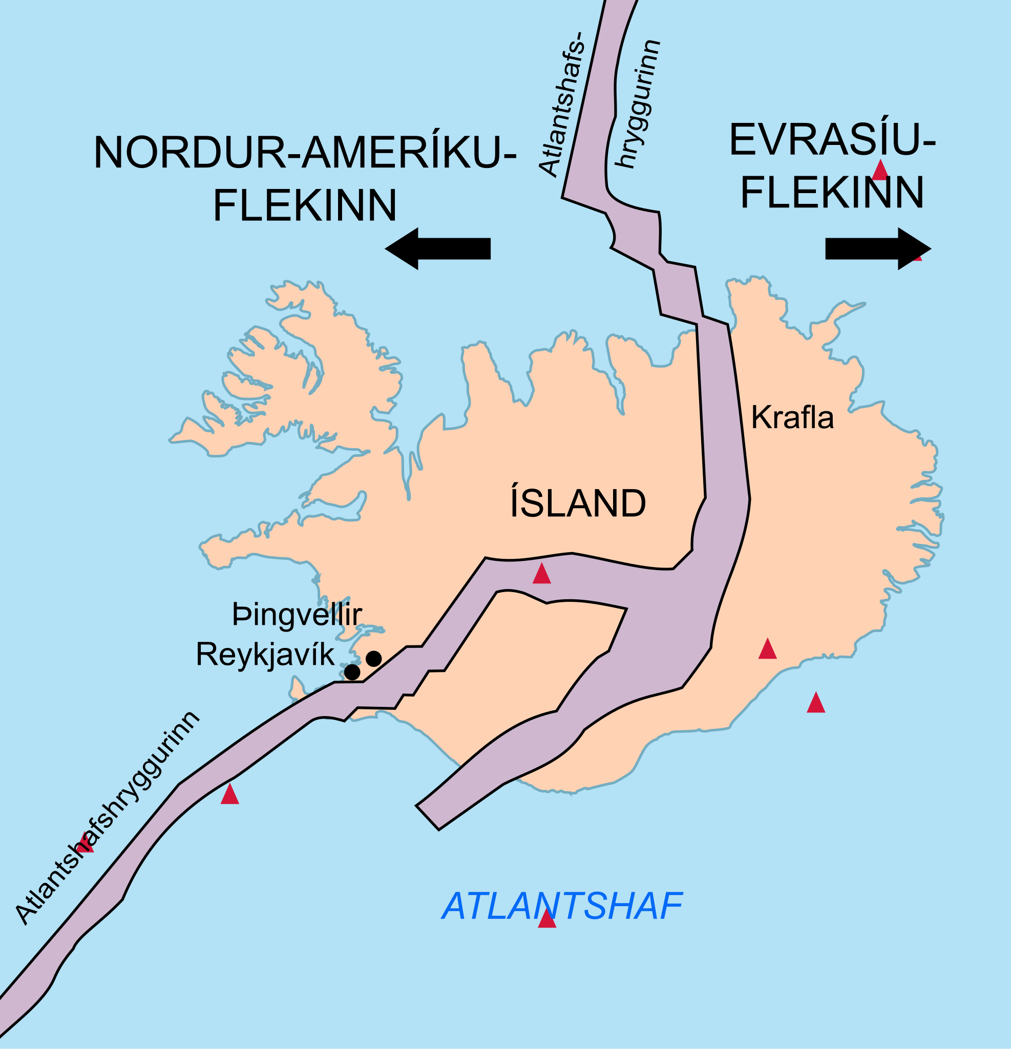
English: Map showing the Mid-Atlantic Ridge splitting Iceland and separating the North American and Eurasian Plates. The map also shows Reykjavik, the capital of Iceland, the Thingvellir area, and the locations of some of Iceland's active volcanoes (red triangles), including Krafla. Translated into Icelandic.
Íslenska: Kort sem sýnir Atlantshafshrygginn og rekbeltið sem klýfur Norður-Ameríkuflekann og Evrasíuflekann í tvennt. Kortið sýnir jafnframt Reykjavík, Þingvelli og legu nokkurra virkustu eldstöðva á Íslandi (sýndar með rauðum þríhyrningi), þar á meðal Kröflu. Þýtt yfir íslensku. |
| Date | |
| Source | http://pubs.usgs.gov/gip/dynamic/understanding.html |
| Author | http://pubs.usgs.gov/gip/dynamic/understanding.html |
| Other versions | Iceland Mid-Atlantic Ridge map.svg |
Licensing
edit
This image is in the public domain in the United States because it only contains materials that originally came from the United States Geological Survey, an agency of the United States Department of the Interior. For more information, see the official USGS copyright policy.
|
File history
Click on a date/time to view the file as it appeared at that time.
| Date/Time | Thumbnail | Dimensions | User | Comment | |
|---|---|---|---|---|---|
| current | 19:13, 20 November 2018 | | 376 × 390 (97 KB) | Maxí (talk | contribs) | {{Information |description ={{en|1=Map showing the Mid-Atlantic Ridge splitting Iceland and separating the North American and Eurasian Plates. The map also shows Reykjavik, the capital of Iceland, the Thingvellir area, and the locations of some of Iceland's active volcanoes (red triangles), including Krafla. Translated into Icelandic.}} {{is|1=Kort sem sýnir Atlantshafshrygginn og rekbeltið sem klýfur Norður-Ameríkuflekann og Evrasíuflekann í tvennt. Kortið sýnir jafnframt Reykjavík, Þingve... |
You cannot overwrite this file.
File usage on Commons
The following 2 pages use this file:
File usage on other wikis
The following other wikis use this file:
- Usage on is.wikipedia.org