File:Ifatke palmachim.jpg

Size of this preview: 800 × 534 pixels. Other resolutions: 320 × 213 pixels | 640 × 427 pixels | 1,024 × 683 pixels.
Original file (1,024 × 683 pixels, file size: 440 KB, MIME type: image/jpeg)
Captions
Captions
Add a one-line explanation of what this file represents
Summary edit
| Description |
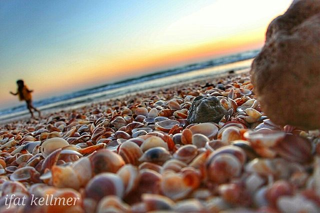
עברית: חוף פלמחים הוא חוף ים השוכן במישור החוף הדרומי, מדרום לראשון לציון ולנחל שורק, ליד קיבוץ פלמחים. אזור החוף הוכרז כגן לאומי.
|
||
| Date | |||
| Source | Own work | ||
| Author | Ifat kellmer |
| Camera location | | View this and other nearby images on: OpenStreetMap |
|---|
חוף פלמחים (לפני השמורה) צולם ביוני 2016
Licensing edit
I, the copyright holder of this work, hereby publish it under the following license:
This file is licensed under the Creative Commons Attribution-Share Alike 4.0 International license.
- You are free:
- to share – to copy, distribute and transmit the work
- to remix – to adapt the work
- Under the following conditions:
- attribution – You must give appropriate credit, provide a link to the license, and indicate if changes were made. You may do so in any reasonable manner, but not in any way that suggests the licensor endorses you or your use.
- share alike – If you remix, transform, or build upon the material, you must distribute your contributions under the same or compatible license as the original.

|
This image was uploaded as part of Wiki Loves Monuments 2016.
|
 |
File history
Click on a date/time to view the file as it appeared at that time.
| Date/Time | Thumbnail | Dimensions | User | Comment | |
|---|---|---|---|---|---|
| current | 10:13, 26 October 2016 | | 1,024 × 683 (440 KB) | Ifatke (talk | contribs) | User created page with UploadWizard |
You cannot overwrite this file.
File usage on Commons
The following page uses this file: