File:Ikhana Unmanned Aircraft.jpg

Original file (3,000 × 2,910 pixels, file size: 2.32 MB, MIME type: image/jpeg)
Captions
Captions
Summary
edit
| Description |
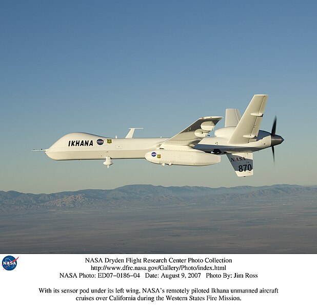
English: NASA and the U.S. Forest Service tested technologies to improve wildfire imaging and mapping capabilities in the Western States Fire Mission. From mid-August through September, 2007, NASA's Dryden (now Armstrong) Flight Research Center flew its remotely piloted Ikhana, a General Atomics Aeronautical Systems Predator B unmanned aircraft system adapted to civil missions, in a series of missions to demonstrate the capabilities of sophisticated new thermal-infrared imaging sensors and real-time data communications equipment developed at NASA's Ames Research Center. The sensor is capable of peering through thick smoke and haze to record hot spots and the progression of wildfires over a lengthy period.
The first flight of the series on August 16, 2007 captured images of California wildfires, including the huge Zaca Fire in Santa Barbara and Ventura Counties. Other flights in the series were to take the aircraft to image wildfires burning in the Pacific Northwest during missions lasting more than 20 hours. The data was overlaid on Google Earth maps and downlinked in near-real time to the Interagency Fire Center in Boise, Idaho, and made available to fire incident commanders to assist them in allocating their fire-fighting resources. Image Number: ED07-0186-04 Date: August 9, 2007 |
| Date | |
| Source | https://www.flickr.com/photos/44494372@N05/20260783196/ |
| Author | NASA on The Commons |
Licensing
edit
This image was taken from Flickr's The Commons. The uploading organization may have various reasons for determining that no known copyright restrictions exist, such as:
More information can be found at https://flickr.com/commons/usage/. Please add additional copyright tags to this image if more specific information about copyright status can be determined. See Commons:Licensing for more information. |
| This image was originally posted to Flickr by NASA on The Commons at https://flickr.com/photos/44494372@N05/20260783196. It was reviewed on 5 February 2024 by FlickreviewR 2 and was confirmed to be licensed under the terms of the No known copyright restrictions. |
File history
Click on a date/time to view the file as it appeared at that time.
| Date/Time | Thumbnail | Dimensions | User | Comment | |
|---|---|---|---|---|---|
| current | 16:23, 5 February 2024 | | 3,000 × 2,910 (2.32 MB) | Ooligan (talk | contribs) | Uploaded a work by NASA on The Commons from https://www.flickr.com/photos/44494372@N05/20260783196/ with UploadWizard |
You cannot overwrite this file.
File usage on Commons
There are no pages that use this file.