File:Illerursprung04.jpg

Size of this preview: 800 × 591 pixels. Other resolutions: 320 × 236 pixels | 640 × 472 pixels | 1,024 × 756 pixels | 1,280 × 945 pixels | 2,235 × 1,650 pixels.
Original file (2,235 × 1,650 pixels, file size: 3.76 MB, MIME type: image/jpeg)
Captions
Captions
Add a one-line explanation of what this file represents
Summary
edit
| Description |
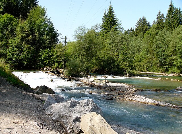
Deutsch: Der Illerursprung bezeichnet den Zusammenfluss von Breitach, Stillach und Trettach bei Oberstdorf in Bayern, Deutschland. Im Bild ist rechts die Breitach, in der Mitte die Stillach und links die Trettach zu erkennen.
English: Illerursprung is the confluence of Breitach (right), Stillach (middle) and Trettach (left) near Oberstdorf in Bavaria, Germany. |
| Date | |
| Source | Own work |
| Author | Nikater |
| Permission (Reusing this file) |
Own work, all rights released (Public domain) |
| Camera location | | View this and other nearby images on: OpenStreetMap |
|---|
Licensing
edit
| I, the copyright holder of this work, release this work into the public domain. This applies worldwide. In some countries this may not be legally possible; if so: I grant anyone the right to use this work for any purpose, without any conditions, unless such conditions are required by law. |
File history
Click on a date/time to view the file as it appeared at that time.
| Date/Time | Thumbnail | Dimensions | User | Comment | |
|---|---|---|---|---|---|
| current | 11:33, 5 September 2011 | | 2,235 × 1,650 (3.76 MB) | Nikater (talk | contribs) | {{Information |Description= {{de|Der Illerursprung bezeichnet den Zusammenfluss von Breitach, Stillach und Trettach bei Oberstdorf in Bayern, Deutschland. Im Bild ist rechts die Breitach, in der Mitte die |
You cannot overwrite this file.
File usage on Commons
There are no pages that use this file.
File usage on other wikis
The following other wikis use this file:
- Usage on de.wikipedia.org
- Usage on nl.wikipedia.org
- Usage on sv.wikipedia.org