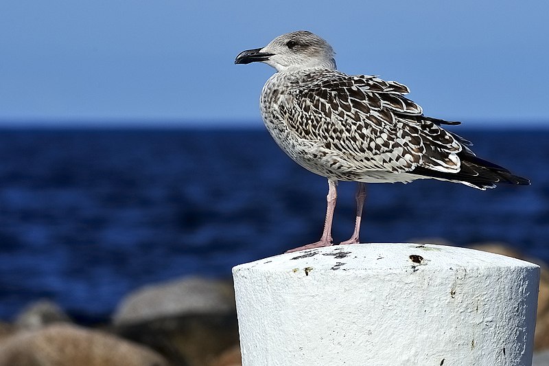
File:Immature gull, Ertholmene, Danmark (125188147).jpg

Original file (2,048 × 1,365 pixels, file size: 512 KB, MIME type: image/jpeg)
Captions
Captions
Summary edit
| Immature gull, Ertholmene, Danmark | |
|---|---|
| Photographer | |
| Title |
Immature gull, Ertholmene, Danmark |
| Description |
500px provided description: immature Gull at Frederiksø, Ertholmene, Danmark Ertholmene, generally called Christiansø, is a small archipelago situated approximately 18 km northeast of Bornholm in the Baltic Sea. Its permanent population is 92 (as of 2013) and its area is 39 hectares (0.39 km2). Ertholmene belongs to Denmark and has the country's easternmost point. Ertholmene consists of three main islands, Christiansø (named after King Christian V), Frederiksø (named after King Frederick IV) and Græsholm, plus a number of minor rocks and skerries. The best known of the latter are Tat and Østerskær, Denmark's easternmost point. Christiansø makes up 22.3 hectares, Frederiksø 4, and Græsholm 11 hectares. Only Christiansø and Frederiksø are inhabited, while Græsholm is a bird reserve. The sound between Christiansø and Frederiksø, a well-sheltered natural harbour, is crossed by a pedestrian bridge that is pulled aside to accommodate larger vessels. [#sea ,#birds ,#baltic ,#wildlife ,#gull ,#ptak ,#mewa ,#Denmark ,#Christiansø] |
| Date | 1 August 2015, 13:33:36 (UTC) |
| Source | Imported from 500px (archived version) by the Archive Team. (detail page) |
| Permission (Reusing this file) |
This file is licensed under the Creative Commons Attribution-Share Alike 3.0 Unported license.
|
| Camera location | 55° 19′ 17.67″ N, 15° 10′ 59.8″ E | View this and other nearby images on: OpenStreetMap |
|---|
File history
Click on a date/time to view the file as it appeared at that time.
| Date/Time | Thumbnail | Dimensions | User | Comment | |
|---|---|---|---|---|---|
| current | 19:30, 7 November 2018 |  | 2,048 × 1,365 (512 KB) | Rodrigo.Argenton (talk | contribs) | Photo Thayer S Gull imported from 500px with import-500px |
You cannot overwrite this file.
File usage on Commons
The following page uses this file:
File usage on other wikis
The following other wikis use this file:
- Usage on da.wikipedia.org
Metadata
This file contains additional information such as Exif metadata which may have been added by the digital camera, scanner, or software program used to create or digitize it. If the file has been modified from its original state, some details such as the timestamp may not fully reflect those of the original file. The timestamp is only as accurate as the clock in the camera, and it may be completely wrong.
| Image title | Denmark, Christianso |
|---|---|
| Camera manufacturer | NIKON CORPORATION |
| Camera model | NIKON D3 |
| Author | Wojciech Gwiozdzik |
| Copyright holder | Copyrights By / Wszelkie Prawa: Wojciech Gwiozdzik |
| Exposure time | 1/800 sec (0.00125) |
| F-number | f/11 |
| ISO speed rating | 200 |
| Date and time of data generation | 09:33, 1 August 2015 |
| Lens focal length | 300 mm |
| Short title | Thayer's Gull |
| Width | 2,739 px |
| Height | 1,826 px |
| Bits per component |
|
| Pixel composition | RGB |
| Orientation | Normal |
| Number of components | 3 |
| Horizontal resolution | 300 dpi |
| Vertical resolution | 300 dpi |
| Software used | Adobe Photoshop CC 2014 (Windows) |
| File change date and time | 21:22, 14 October 2015 |
| White point chromaticity |
|
| Chromaticities of primarities |
|
| Color space transformation matrix coefficients |
|
| Y and C positioning | Centered |
| Pair of black and white reference values |
|
| Exposure Program | Normal program |
| Exif version | 2.3 |
| Date and time of digitizing | 09:33, 1 August 2015 |
| Meaning of each component |
|
| APEX shutter speed | 9.643856 |
| APEX aperture | 6.918863 |
| APEX exposure bias | −0.66666666666667 |
| Maximum land aperture | 5 APEX (f/5.66) |
| Metering mode | Pattern |
| Light source | Unknown |
| Flash | Flash did not fire |
| DateTime subseconds | 75 |
| DateTimeOriginal subseconds | 75 |
| DateTimeDigitized subseconds | 75 |
| Supported Flashpix version | 1 |
| Color space | Uncalibrated |
| Sensing method | One-chip color area sensor |
| File source | Digital still camera |
| Scene type | A directly photographed image |
| Custom image processing | Normal process |
| Exposure mode | Auto exposure |
| White balance | Auto white balance |
| Digital zoom ratio | 1 |
| Focal length in 35 mm film | 300 mm |
| Scene capture type | Standard |
| Scene control | None |
| Contrast | Normal |
| Saturation | Normal |
| Sharpness | Hard |
| Subject distance range | Unknown |
| GPS tag version | 0.0.2.2 |