File:Inde-Ueberflutung Lamersdorf.jpg

Size of this preview: 800 × 450 pixels. Other resolutions: 320 × 180 pixels | 640 × 360 pixels | 1,024 × 576 pixels | 1,280 × 720 pixels | 2,560 × 1,441 pixels | 4,028 × 2,267 pixels.
Original file (4,028 × 2,267 pixels, file size: 1.48 MB, MIME type: image/jpeg)
Captions
Captions
Add a one-line explanation of what this file represents
Summary edit
| Description |
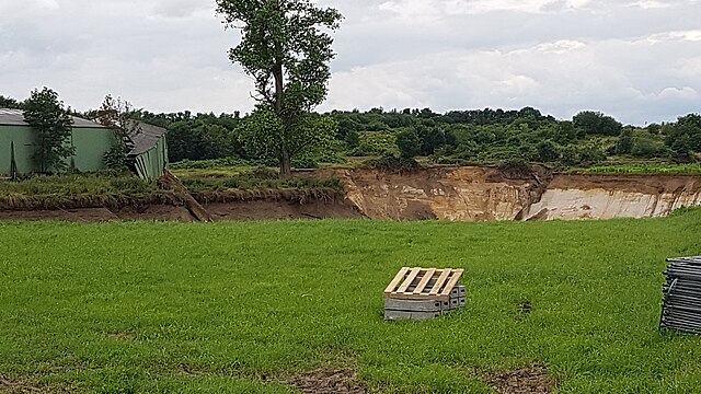
Deutsch: Blick von der Keltenstraße nach Westen 11 Tage nach der Überflutung. Der neu entstandene Graben entspricht dem früheren Verlauf der Inde bis zu ihrer Umleitung 2005. Durch das Abrutschen des Erdreichs in den Graben (und nachfolgend in den Tagebau) sackte der hintere Teil der grünen Lagerhalle ab. |
| Date | |
| Source | Own work |
| Author | KlausMiniwolf |
| Camera location | | View this and other nearby images on: OpenStreetMap |
|---|
Original-Dateiname: 2021-07-26 12-51-10 kW-S7 Inde-Ueberflutung Lamersdorf A16x9
Licensing edit
I, the copyright holder of this work, hereby publish it under the following license:
This file is licensed under the Creative Commons Attribution-Share Alike 4.0 International license.
- You are free:
- to share – to copy, distribute and transmit the work
- to remix – to adapt the work
- Under the following conditions:
- attribution – You must give appropriate credit, provide a link to the license, and indicate if changes were made. You may do so in any reasonable manner, but not in any way that suggests the licensor endorses you or your use.
- share alike – If you remix, transform, or build upon the material, you must distribute your contributions under the same or compatible license as the original.
File history
Click on a date/time to view the file as it appeared at that time.
| Date/Time | Thumbnail | Dimensions | User | Comment | |
|---|---|---|---|---|---|
| current | 18:45, 26 July 2021 | | 4,028 × 2,267 (1.48 MB) | KlausMiniwolf (talk | contribs) | Uploaded own work with UploadWizard |
You cannot overwrite this file.
File usage on Commons
There are no pages that use this file.
File usage on other wikis
The following other wikis use this file:
- Usage on de.wikipedia.org