File:Indonesia Badung Petang district location map.svg

Size of this PNG preview of this SVG file: 600 × 600 pixels. Other resolutions: 240 × 240 pixels | 480 × 480 pixels | 768 × 768 pixels | 1,024 × 1,024 pixels | 2,048 × 2,048 pixels | 1,250 × 1,250 pixels.
Original file (SVG file, nominally 1,250 × 1,250 pixels, file size: 336 KB)
Captions
Captions
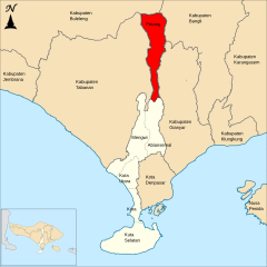
Map of Petang district in Badung Regency, Bali province, Indonesia
Summary edit
| Description |
English: Map of South Petang in Badung Regency, Bali province, Indonesia
Bahasa Indonesia: Peta kecamatan Petang di Kabupaten Badung, Bali, Indonesia |
| Date | |
| Source | Own work |
| Author | Joseagush |
Licensing edit
I, the copyright holder of this work, hereby publish it under the following license:
This file is licensed under the Creative Commons Attribution-Share Alike 4.0 International license.
- You are free:
- to share – to copy, distribute and transmit the work
- to remix – to adapt the work
- Under the following conditions:
- attribution – You must give appropriate credit, provide a link to the license, and indicate if changes were made. You may do so in any reasonable manner, but not in any way that suggests the licensor endorses you or your use.
- share alike – If you remix, transform, or build upon the material, you must distribute your contributions under the same or compatible license as the original.
File history
Click on a date/time to view the file as it appeared at that time.
| Date/Time | Thumbnail | Dimensions | User | Comment | |
|---|---|---|---|---|---|
| current | 04:28, 7 July 2020 | | 1,250 × 1,250 (336 KB) | Angayubagia (talk | contribs) | update text |
| 08:50, 25 June 2020 |  | 1,250 × 1,250 (319 KB) | Angayubagia (talk | contribs) | Uploaded own work with UploadWizard |
You cannot overwrite this file.
File usage on Commons
There are no pages that use this file.
File usage on other wikis
The following other wikis use this file:
- Usage on ban.wikipedia.org
- Usage on de.wikipedia.org
- Usage on id.wikipedia.org