File:Indonesia Rebublic provinces map-fr.svg

Size of this PNG preview of this SVG file: 800 × 375 pixels. Other resolutions: 320 × 150 pixels | 640 × 300 pixels | 1,024 × 480 pixels | 1,280 × 600 pixels | 2,560 × 1,201 pixels | 1,322 × 620 pixels.
Original file (SVG file, nominally 1,322 × 620 pixels, file size: 420 KB)
Captions
Captions
Add a one-line explanation of what this file represents
Summary edit
| Description |
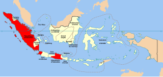
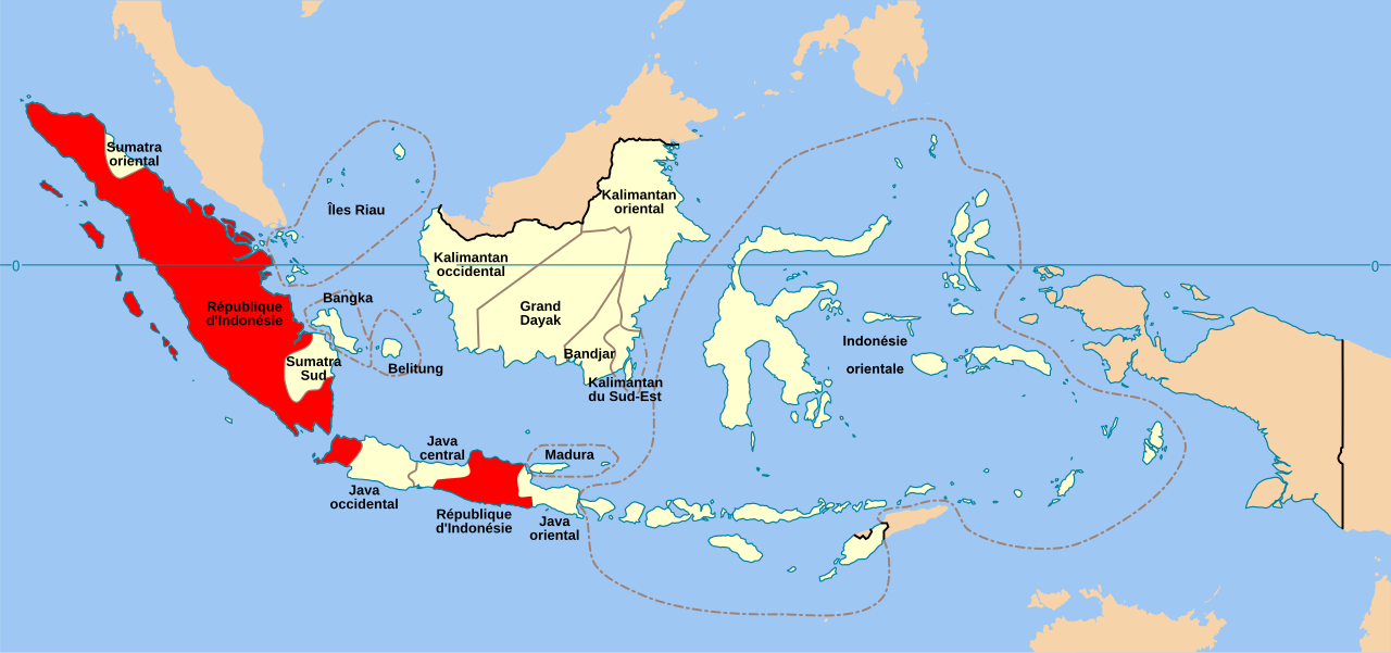
Français : Carte en français de la République des États-Unis d'Indonésie English: Map in French showing the United States of Indonesia Bahasa Indonesia: Republik Indonesia Serikat |
| Date | |
| Source | travail personnel ; derivative work from File:Republik Indonesia Serikat.png created by User:Davidelit and File:Indonesia provinces map-fr.svg created by Sardon (original blank map : File:Indonesia provinces blank map.svg by User:Indon). Additional information for coloring: George McTurnan Kahin, 'Nationalism and Revolution in Indonesia' Cornell University Press 1952. |
| Author | Bourrichon |
| Other versions |
 |

|
This SVG file contains embedded text that can be translated into your language, using any capable SVG editor, text editor or the SVG Translate tool. For more information see: About translating SVG files. |
This W3C-unspecified vector image was created with Inkscape .
Licensing edit
I, the copyright holder of this work, hereby publish it under the following licenses:

|
Permission is granted to copy, distribute and/or modify this document under the terms of the GNU Free Documentation License, Version 1.2 or any later version published by the Free Software Foundation; with no Invariant Sections, no Front-Cover Texts, and no Back-Cover Texts. A copy of the license is included in the section entitled GNU Free Documentation License. |
This file is licensed under the Creative Commons Attribution-Share Alike 3.0 Unported, 2.5 Generic, 2.0 Generic and 1.0 Generic license.
- You are free:
- to share – to copy, distribute and transmit the work
- to remix – to adapt the work
- Under the following conditions:
- attribution – You must give appropriate credit, provide a link to the license, and indicate if changes were made. You may do so in any reasonable manner, but not in any way that suggests the licensor endorses you or your use.
- share alike – If you remix, transform, or build upon the material, you must distribute your contributions under the same or compatible license as the original.
You may select the license of your choice.
File history
Click on a date/time to view the file as it appeared at that time.
| Date/Time | Thumbnail | Dimensions | User | Comment | |
|---|---|---|---|---|---|
| current | 14:50, 10 June 2009 | | 1,322 × 620 (420 KB) | Bourrichon (talk | contribs) | +see |
| 14:49, 10 June 2009 |  | 1,322 × 620 (420 KB) | Bourrichon (talk | contribs) | {{Information |Description={{fr| Carte en français de la République des États-Unis d'Indonésie}}{{en|Map in French showing the United States of Indonesia}}{{id|[[:id:R |
You cannot overwrite this file.
File usage on Commons
The following 2 pages use this file:
File usage on other wikis
The following other wikis use this file: