File:Infraestructuras de productos petrolíferos en España 2012-2015 mapa 14818 spa.jpg

Size of this preview: 800 × 575 pixels. Other resolutions: 320 × 230 pixels | 640 × 460 pixels | 1,024 × 736 pixels | 1,280 × 921 pixels | 2,204 × 1,585 pixels.
Original file (2,204 × 1,585 pixels, file size: 518 KB, MIME type: image/jpeg)
Captions
Captions
Add a one-line explanation of what this file represents
Summary
edit
| Description |
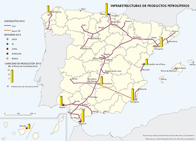
Español: Infraestructuras de productos petrolíferos en España 2012-2015 |
| Date | |
| Source | Altas Nacional de España |
| Author | Instituto Geográfico Nacional, Centro Nacional de Información Geográfica. Véase la lista de participantes |
Licensing
edit
This file is licensed under the Creative Commons Attribution-Share Alike 4.0 International license.
- You are free:
- to share – to copy, distribute and transmit the work
- to remix – to adapt the work
- Under the following conditions:
- attribution – You must give appropriate credit, provide a link to the license, and indicate if changes were made. You may do so in any reasonable manner, but not in any way that suggests the licensor endorses you or your use.
- share alike – If you remix, transform, or build upon the material, you must distribute your contributions under the same or compatible license as the original.
File history
Click on a date/time to view the file as it appeared at that time.
| Date/Time | Thumbnail | Dimensions | User | Comment | |
|---|---|---|---|---|---|
| current | 23:16, 12 September 2021 | | 2,204 × 1,585 (518 KB) | Lojwe (talk | contribs) | Cropped 5 % horizontally, 6 % vertically using CropTool with precise mode. |
| 23:16, 12 September 2021 |  | 2,313 × 1,693 (435 KB) | Lojwe (talk | contribs) | Uploaded a work by Instituto Geográfico Nacional, Centro Nacional de Información Geográfica. Véase la [http://www.ign.es/resources/ane/participantes.pdf lista de participantes] from [http://atlasnacional.ign.es/wane/Archivo:Espana_Infraestructuras-de-productos-petroliferos_2012-2015_mapa_14818_spa.jpg Altas Nacional de España] with UploadWizard |
You cannot overwrite this file.
File usage on Commons
There are no pages that use this file.
File usage on other wikis
The following other wikis use this file:
- Usage on es.wikipedia.org
- Usage on fr.wikipedia.org