File:Ingenuity total path flight72.png

Size of this preview: 800 × 450 pixels. Other resolutions: 320 × 180 pixels | 640 × 360 pixels | 1,024 × 576 pixels | 1,280 × 720 pixels | 1,920 × 1,080 pixels.
Original file (1,920 × 1,080 pixels, file size: 3.03 MB, MIME type: image/png)
Captions
Captions
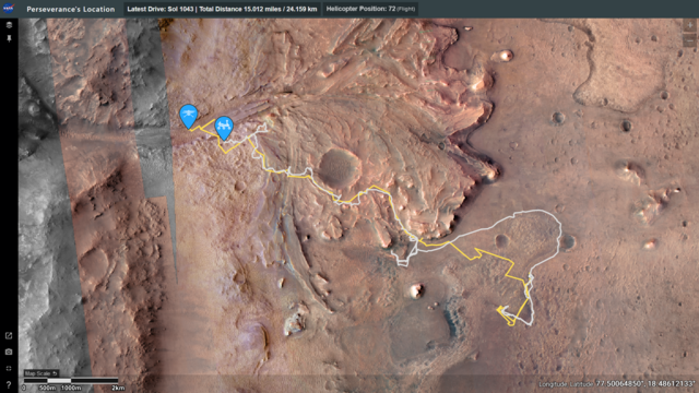
Ingenuity total flight path
Summary edit
| Description |
English: Map of the total flight path of NASA's Ingenuity helicopter (yellow), together with the ground track of the Perseverance Rover (grey), between landing on Mars in 2021 and Ingenuity's final flight on 18 January 2024 |
| Date | |
| Source | NASA's "Where is Perseverance?" website, https://mars.nasa.gov/maps/location/?mission=M20&site=NOW |
| Author | NASA/JPL |
Licensing edit
| This file is in the public domain in the United States because it was solely created by NASA. NASA copyright policy states that "NASA material is not protected by copyright unless noted". (See Template:PD-USGov, NASA copyright policy page or JPL Image Use Policy.) | ||
 |
Warnings:
|
File history
Click on a date/time to view the file as it appeared at that time.
| Date/Time | Thumbnail | Dimensions | User | Comment | |
|---|---|---|---|---|---|
| current | 14:23, 28 January 2024 | | 1,920 × 1,080 (3.03 MB) | Renerpho (talk | contribs) | Previous version was wrong image |
| 14:20, 28 January 2024 |  | 1,870 × 1,080 (1.28 MB) | Renerpho (talk | contribs) | Uploaded a work by NASA/JPL from NASA's "Where is Perseverance?" website, https://mars.nasa.gov/maps/location/?mission=M20&site=NOW&mapLon=77.3866635512744&mapLat=18.473269666110674&mapZoom=13&globeLon=77.42958068847659&globeLat=18.463327291058505&globeZoom=11&globeCamera=0,-9765.625,0,0,1,0&panePercents=0,100,0&on=Rover Position$1.00,Rover Drive Path$1.00,Surface View$1.00,Helicopter Position$1.00,Helicopter Waypoints$1.00,Helicopter Flight Path$1.00,Flight Test Zone$1.00,Color Basemap$1.00,... |
You cannot overwrite this file.
File usage on Commons
The following 2 pages use this file: