File:Inland empire within southern california.png
No higher resolution available.
Inland_empire_within_southern_california.png (342 × 308 pixels, file size: 160 KB, MIME type: image/png)
Captions
Captions
Add a one-line explanation of what this file represents
Summary
edit
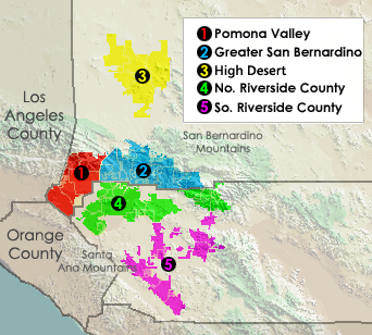
English: The Inland Empire metropolitan region of Southern California.
- Located in Riverside and San Bernardino Counties.
Note: This map shows only Pomona Valley area located in San Bernardino County and does show the Cities of Pomona and Claremont in Los Angeles County also located in "Pomona Valley".
Transwiki approved by: w:en:User:Dmcdevit
This image was copied from wikipedia:en. The original description was:
Displays different regions in Southern California's Inland Empire.
Created using Census Data, USGS imagery. put together by myself.
Licensing
edit
| I, the copyright holder of this work, release this work into the public domain. This applies worldwide. In some countries this may not be legally possible; if so: I grant anyone the right to use this work for any purpose, without any conditions, unless such conditions are required by law. |
This image or file is a work of a United States Census Bureau employee, taken or made as part of that person's official duties. As a work of the U.S. federal government, the image is in the public domain.
|
 |
This image is in the public domain in the United States because it only contains materials that originally came from the United States Geological Survey, an agency of the United States Department of the Interior. For more information, see the official USGS copyright policy.
|
Original upload log
edit
| date/time | username | resolution | size | edit summary |
|---|---|---|---|---|
| 07:44, 5 March 2006 | w:en:User:Ab189 | 342×308 | 160 KB | Relief map is a work by the USGS, boundaries drawn by the US Census, put together by me. {{PD-USGov-Interior-USGS}} {{PD-USGov-DOC-Census}} |
| 03:58, 24 December 2005 | w:en:User:Ab189 | 342×308 | 19 KB | |
| 03:54, 24 December 2005 | w:en:User:Ab189 | 342×308 | 19 KB | Displays different regions in Southern California's Inland Empire. Created using Census Data. {{PD-self}} {{PD-USGov-DOC-Census}} |
Image description page history
edit
File history
Click on a date/time to view the file as it appeared at that time.
| Date/Time | Thumbnail | Dimensions | User | Comment | |
|---|---|---|---|---|---|
| current | 04:05, 16 September 2007 | | 342 × 308 (160 KB) | BetacommandBot (talk | contribs) | Transwiki approved by: w:en:User:Dmcdevit This image was copied from wikipedia:en. The original description was: Displays different regions in Southern California's Inland Empire. Created using Census Data, USGS imagery. put together by myself. == |
You cannot overwrite this file.
File usage on Commons
There are no pages that use this file.
File usage on other wikis
The following other wikis use this file:
- Usage on cs.wikipedia.org
- Usage on en.wikipedia.org
- Usage on nl.wikipedia.org
- Usage on ru.wikipedia.org