File:Inset Map of Fairfield & Meyers Mills from 1860 Somerset County, Pennsylvania, Map by Edward L Walker.jpg

Size of this preview: 548 × 599 pixels. Other resolutions: 219 × 240 pixels | 439 × 480 pixels | 702 × 768 pixels | 937 × 1,024 pixels | 1,833 × 2,004 pixels.
Original file (1,833 × 2,004 pixels, file size: 573 KB, MIME type: image/jpeg)
Captions
Captions
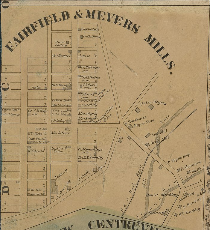
Meyers Mills, Somerset County, Pennsylvania, 1860
Summary
edit
| Description |
English: Inset map of Fairfield & Meyers Mills taken from 1860 Edward L. Walker map of Somerset County, Pennsylvania, available at the Library of Congress website |
| Date | |
| Source | https://www.loc.gov/item/2012592183/ |
| Author | Edward L. Walker |
| Camera location | | View this and other nearby images on: OpenStreetMap |
|---|
Licensing
edit
This work is in the public domain in the United States because it was published (or registered with the U.S. Copyright Office) before January 1, 1929.
Public domain works must be out of copyright in both the United States and in the source country of the work in order to be hosted on the Commons. If the work is not a U.S. work, the file must have an additional copyright tag indicating the copyright status in the source country.
Note: This tag should not be used for sound recordings. |
File history
Click on a date/time to view the file as it appeared at that time.
| Date/Time | Thumbnail | Dimensions | User | Comment | |
|---|---|---|---|---|---|
| current | 02:55, 22 May 2020 | | 1,833 × 2,004 (573 KB) | Michael Sechler (talk | contribs) | Uploaded a work by Edward L. Walker from https://www.loc.gov/item/2012592183/ with UploadWizard |
You cannot overwrite this file.
File usage on Commons
There are no pages that use this file.
File usage on other wikis
The following other wikis use this file:
- Usage on en.wikipedia.org