File:Intercitynet NL 2009.png

Size of this preview: 507 × 600 pixels. Other resolutions: 203 × 240 pixels | 406 × 480 pixels | 649 × 768 pixels | 866 × 1,024 pixels | 1,732 × 2,048 pixels | 2,810 × 3,323 pixels.
Original file (2,810 × 3,323 pixels, file size: 511 KB, MIME type: image/png)
Captions
Captions
Add a one-line explanation of what this file represents
Summary edit
| Description |
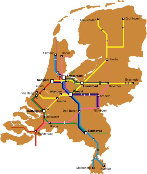
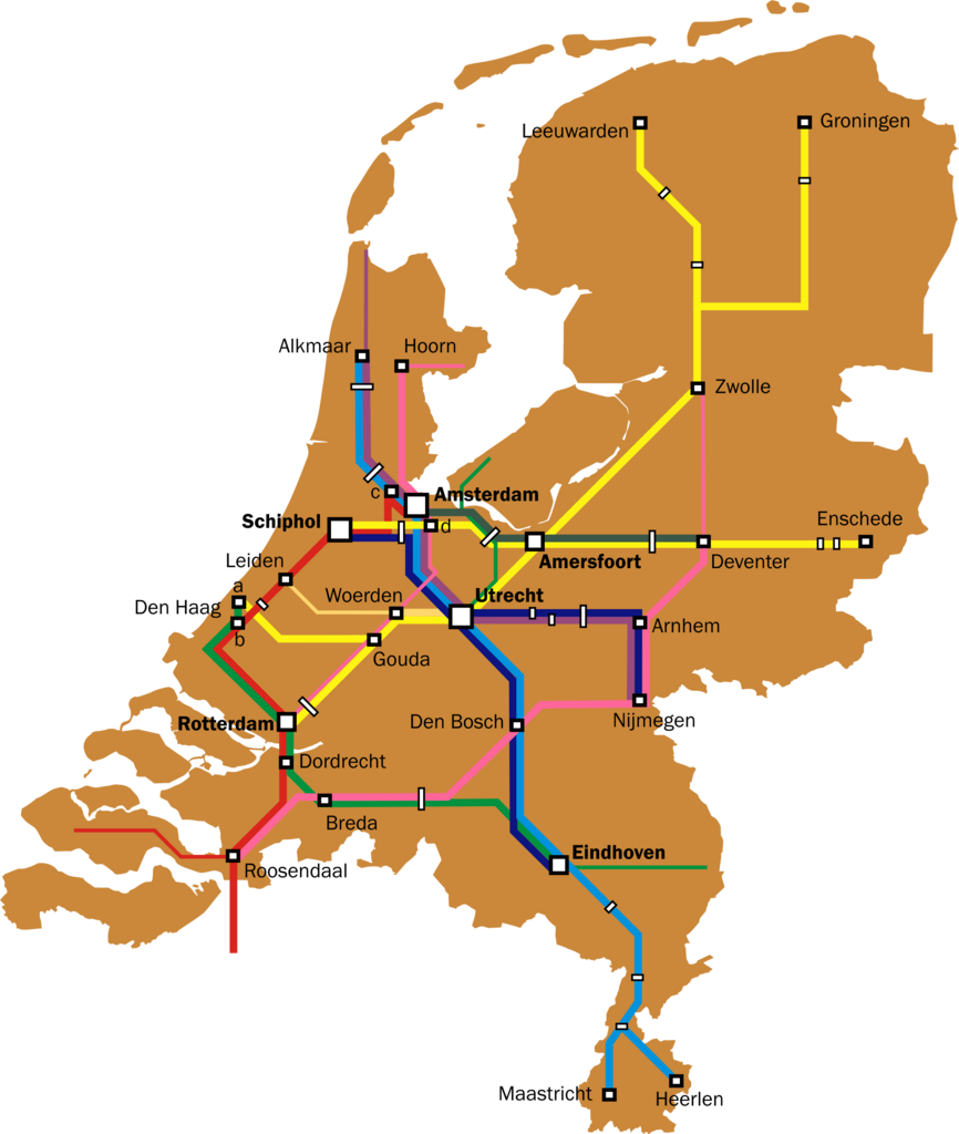
English: Map of the Dutch Intercity network. Thin lines are used for all-stops services that are a continuation of intercity services (e.g. the Rotterdam-Gouda-Amsterdam leg of the Enkhuizen-Rotterdam trains, and the Roosendaal - Vlissingen leg of the Amsterdam-Vlissingen trains).
Further notes:
|
| Date | |
| Source | Own work |
| Author | Classical geographer |
| Other versions | Intercitynet_NL_2010.png, the most recent version. |
Licensing edit
I, the copyright holder of this work, hereby publish it under the following license:
This file is licensed under the Creative Commons Attribution 3.0 Unported license.
- You are free:
- to share – to copy, distribute and transmit the work
- to remix – to adapt the work
- Under the following conditions:
- attribution – You must give appropriate credit, provide a link to the license, and indicate if changes were made. You may do so in any reasonable manner, but not in any way that suggests the licensor endorses you or your use.
File history
Click on a date/time to view the file as it appeared at that time.
| Date/Time | Thumbnail | Dimensions | User | Comment | |
|---|---|---|---|---|---|
| current | 17:36, 5 August 2011 | | 2,810 × 3,323 (511 KB) | Classical geographer (talk | contribs) | {{Information |Description ={{en|1=Map of the Dutch Intercity network. Thin lines are used for all-stops services that are a continuation of intercity services (e.g. the Rotterdam-Gouda-Amsterdam leg of the Enkhuizen-Rotterdam trains, and the Roosendaa |
You cannot overwrite this file.
File usage on Commons
The following 2 pages use this file:
- User:Classical geographer
- File:Intercitynet NL 2011.png (file redirect)
File usage on other wikis
The following other wikis use this file:
- Usage on nl.wikipedia.org