File:International Load Line on "Alexander Grin" - geograph.org.uk - 1759965.jpg

Size of this preview: 721 × 600 pixels. Other resolutions: 289 × 240 pixels | 577 × 480 pixels | 1,000 × 832 pixels.
Original file (1,000 × 832 pixels, file size: 468 KB, MIME type: image/jpeg)
Captions
Captions
Add a one-line explanation of what this file represents
Summary
edit
| Description |
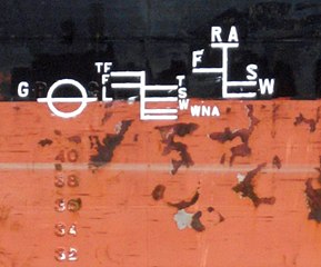
English: International Load Line on "Alexander Grin" The International Load Line or Plimsoll Line (waterline), positioned amidships, indicates the legal limit to which a ship may be loaded for specific water types and temperatures. The GL initials on the left indicate that the load line was surveyed by the Germanischer Lloyd classification society.
|
||
| Date | |||
| Source | From geograph.org.uk | ||
| Author | David Wright | ||
| Attribution (required by the license) | David Wright / International Load Line on "Alexander Grin" / | ||
| Camera location | | View this and other nearby images on: OpenStreetMap |
|---|
_heading:67.00&language=en)
| Object location | | View this and other nearby images on: OpenStreetMap |
|---|
_heading:67.00&language=en)
Licensing
edit

|
This image was taken from the Geograph project collection. See this photograph's page on the Geograph website for the photographer's contact details. The copyright on this image is owned by David Wright and is licensed for reuse under the Creative Commons Attribution-ShareAlike 2.0 license.
|
This file is licensed under the Creative Commons Attribution-Share Alike 2.0 Generic license.
Attribution: David Wright
- You are free:
- to share – to copy, distribute and transmit the work
- to remix – to adapt the work
- Under the following conditions:
- attribution – You must give appropriate credit, provide a link to the license, and indicate if changes were made. You may do so in any reasonable manner, but not in any way that suggests the licensor endorses you or your use.
- share alike – If you remix, transform, or build upon the material, you must distribute your contributions under the same or compatible license as the original.
File history
Click on a date/time to view the file as it appeared at that time.
| Date/Time | Thumbnail | Dimensions | User | Comment | |
|---|---|---|---|---|---|
| current | 23:16, 5 March 2011 | | 1,000 × 832 (468 KB) | GeographBot (talk | contribs) | == {{int:filedesc}} == {{Information |description={{en|1=International Load Line on "Alexander Grin" The International Load Line or Plimsoll Line (waterline), positioned amidships, indicates the legal limit to which a ship may be loaded for specific water |
You cannot overwrite this file.
File usage on Commons
There are no pages that use this file.