File:Intersection of streets 204 and 223 - 2015 Mina stampede.svg

Size of this PNG preview of this SVG file: 800 × 518 pixels. Other resolutions: 320 × 207 pixels | 640 × 414 pixels | 1,024 × 662 pixels | 1,280 × 828 pixels | 2,560 × 1,656 pixels | 2,835 × 1,834 pixels.
Original file (SVG file, nominally 2,835 × 1,834 pixels, file size: 6.72 MB)
Captions
Captions
Add a one-line explanation of what this file represents
Summary edit
| Description |
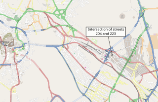
English: Intersection of streets 204 and 223 - 2015 Mina stampede فارسی: تقاطع خیابان 204 و 223 محل سانحه منا در نزدیکی جمرات |
| Date | |
| Source |
Map from OpenStreetMap (vector export) - https://www.openstreetmap.org/#map=13/21.4173/39.8405 |
| Author | OpenStreetMap contributors, User:BurritoBazooka added labels and translations for some place names |
| Other versions |
  |
Licensing edit
| This work contains information from OpenStreetMap, which is made available under the Open Database License (ODbL).
The ODbL does not require any particular license for maps produced from ODbL data. Prior to 1 August 2020, map tiles produced by the OpenStreetMap Foundation were licensed under the CC-BY-SA-2.0 license. Maps produced by other people may be subject to other licences. |
File history
Click on a date/time to view the file as it appeared at that time.
| Date/Time | Thumbnail | Dimensions | User | Comment | |
|---|---|---|---|---|---|
| current | 04:51, 27 October 2015 | | 2,835 × 1,834 (6.72 MB) | BurritoBazooka (talk | contribs) | made Mecca and Grand Mosque labels more prominent. Removed a title from SVG source relevant to a group of objects, which my browser rendered as the whole file's title. |
| 04:14, 27 October 2015 |  | 2,835 × 1,834 (6.72 MB) | BurritoBazooka (talk | contribs) | User created page with UploadWizard |
You cannot overwrite this file.
File usage on Commons
The following page uses this file: