File:Inverted channels Mars PIA08070.jpg

Original file (651 × 1,533 pixels, file size: 147 KB, MIME type: image/jpeg)
Captions
Captions

|
This file was moved to Wikimedia Commons from en.wikipedia using a bot script. All source information is still present. It requires review. Additionally, there may be errors in any or all of the information fields; information on this file should not be considered reliable and the file should not be used until it has been reviewed and any needed corrections have been made. Once the review has been completed, this template should be removed. For details about this file, see below. Check now! |
| Description |
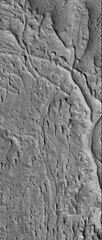
English: Original Caption Released with Image:
13 April 2006 This Mars Global Surveyor (MGS) Mars Orbiter Camera (MOC) image shows ridges exposed by erosion in the Aeolis region of Mars. The curved and crisscrossing ridges were once channels in a fan of sediment deposited in the Aeolis lowlands. The channels were more resistant to wind erosion than the surrounding materials, so today they are left standing as ridges rather than valleys. Location near: 6.1°S, 209.0°W Image width: ~3 km (~1.9 mi) Illumination from: lower left Season: Southern Summer Image Credit: NASA/JPL/Malin Space Science Systems Original image found at: [1] |
| Source | |
| Author |
Licensing edit
| This file is in the public domain in the United States because it was solely created by NASA. NASA copyright policy states that "NASA material is not protected by copyright unless noted". (See Template:PD-USGov, NASA copyright policy page or JPL Image Use Policy.) | ||
 |
Warnings:
|
Original upload log edit
- 2006-07-11 15:34 Cuppysfriend 651×1533× (150950 bytes) Original Caption Released with Image: 13 April 2006 This [[Mars Global Surveyor]] (MGS) Mars Orbiter Camera (MOC) image shows ridges exposed by erosion in the Aeolis region of [[Mars]]. The curved and crisscrossing ridges were once channels in a fan of s
File history
Click on a date/time to view the file as it appeared at that time.
| Date/Time | Thumbnail | Dimensions | User | Comment | |
|---|---|---|---|---|---|
| current | 22:11, 28 May 2009 | | 651 × 1,533 (147 KB) | File Upload Bot (Magnus Manske) (talk | contribs) | {{BotMoveToCommons|en.wikipedia|year={{subst:CURRENTYEAR}}|month={{subst:CURRENTMONTHNAME}}|day={{subst:CURRENTDAY}}}} {{Information |Description={{en|Original Caption Released with Image: 13 April 2006 This en:Mars Global Surveyor (MGS) Mars Orbi |
You cannot overwrite this file.
File usage on Commons
There are no pages that use this file.
File usage on other wikis
The following other wikis use this file:
- Usage on en.wikipedia.org
- Usage on zh.wikipedia.org