File:Iota 2020-11-16 1500Z.jpg

Original file (4,979 × 4,182 pixels, file size: 4.03 MB, MIME type: image/jpeg)
Captions
Captions
Summary
edit
| Description |
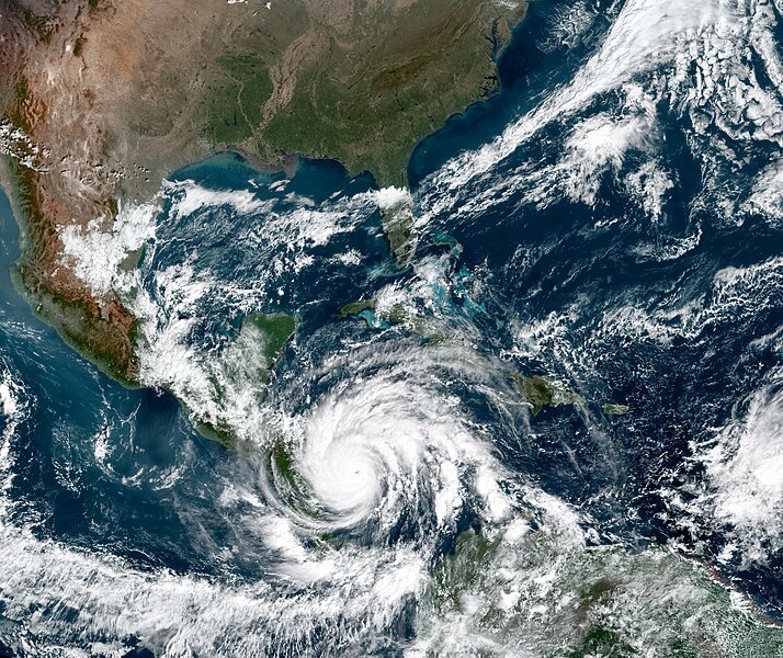
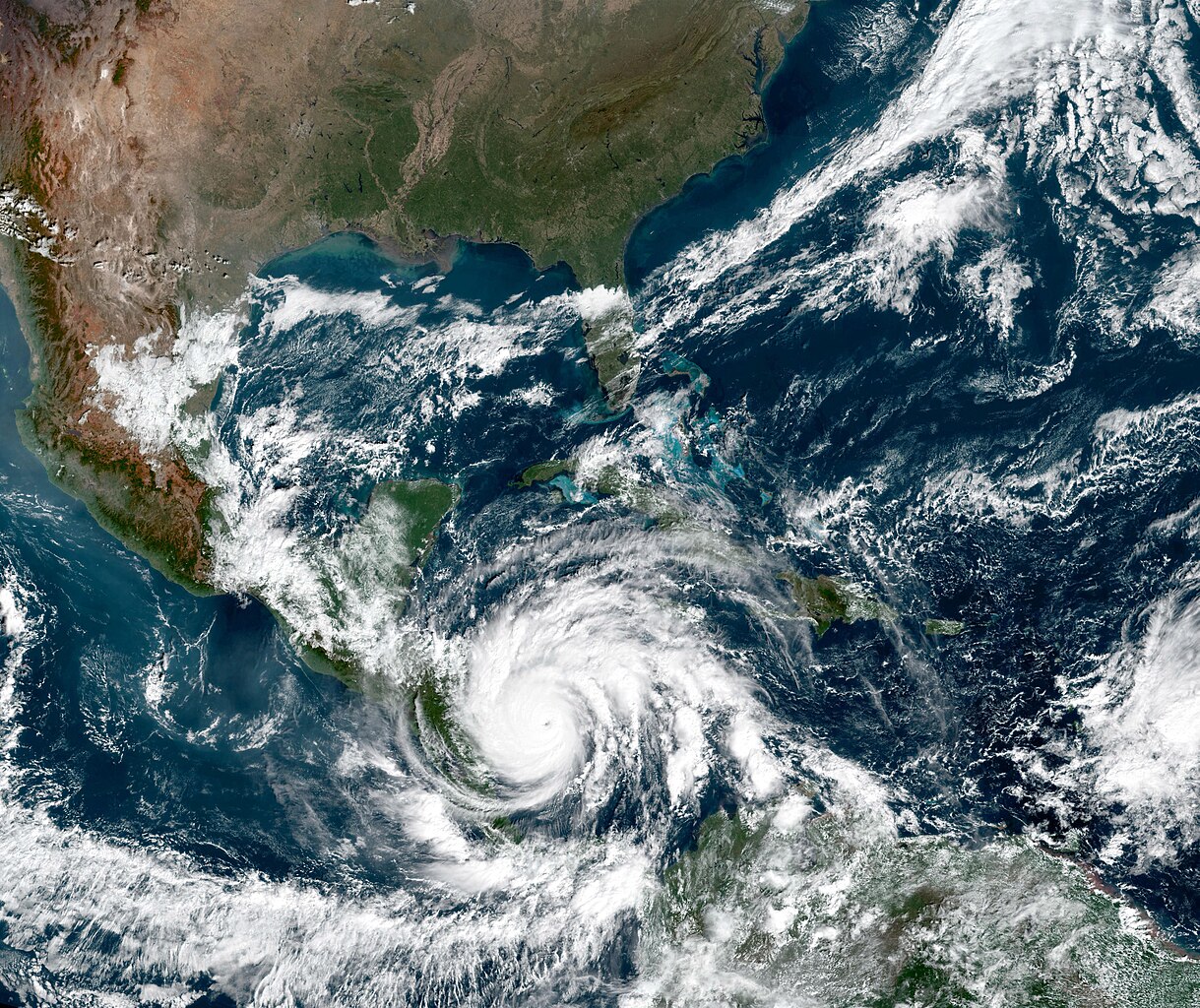
English: Less than two weeks after being hit by category 4 Hurricane Eta, several Central American countries braced for the arrival of category 5 Hurricane Iota. The U.S. National Hurricane Center (NHC) warned of potentially devastating storm surges and winds, along with torrential rain that will fall upon areas already coping with damaged levees and swollen lakes, reservoirs, and rivers. Iota appeared headed for landfall late on November 16 in northern Nicaragua, likely within tens of kilometers from where Eta hit on November 3, 2020.
Iota is the strongest hurricane and 30th named storm of the 2020 Atlantic season, the most since modern record-keeping began. (The previous record of 28 was set in 2005.) It also marked the first time that two hurricanes have formed in the Atlantic in any November. Iota is the 13th storm to reach hurricane strength this year; the average hurricane year brings 11.5 named storms and six hurricanes. As of 1 p.m. U.S. Eastern Time on November 16, the NHC had issued hurricane warnings for large portions of coastal Nicaragua and Honduras. Iota had strengthened to a category 5 storm, with sustained winds of 260 kilometers (160 miles) per hour. Forecasters warned of coastal storm surges as high as 4.5 to 6 meters (15 to 20 feet) and rainfall amounts between 250 to 750 millimeters (10 to 30 inches) across parts of Nicaragua, Honduras, Guatemala, and Belize. The natural-color image above was acquired at 10 a.m. local time (1500 Universal Time) on November 16 by the Advanced Baseline Imager (ABI) on GOES-16. The satellite is operated by the National Oceanic and Atmospheric Administration (NOAA), which includes the National Hurricane Center. NASA helps develop and launch the GOES series of satellites. Tropical storm Iota reached hurricane strength early on November 15. Over the course of 36 hours, wind speeds increased by 160 kilometers (100 miles) per hour—well beyond the threshold of 55 kilometers (35 miles) per hour that meteorologists refer to as “rapid intensification.” The storm grew over particularly warm Caribbean waters, which are known to fuel hurricanes. La Niña conditions in the eastern Pacific may also have played a role, as such events typically reduce wind shear that can break up storms. Iota is the tenth storm to undergo rapid intensification in 2020. Research meteorologist Philip Klotzbach of Colorado State University, who is also a hurricane historian, noted on Twitter that Iota is the just the second Atlantic hurricane to ever reach category 5 intensity in November. It is also the fifth Atlantic hurricane to form after October 1, 2020. The first 24 named storms of the year produced two major hurricanes; the last six storms have produced four major hurricanes. Klotzbach also noted that before 2020, only four category 4 or 5 hurricanes had ever made landfall in Nicaragua. Now two are going to land in the span of two weeks. |
| Date | |
| Source | https://earthobservatory.nasa.gov/images/147539/dangerous-hurricane-iota-sets-late-season-records |
| Author | NASA Earth Observatory images by Joshua Stevens, using GOES 16 imagery courtesy of NOAA and the National Environmental Satellite, Data, and Information Service (NESDIS). Story by Michael Carlowicz, with scientific interpretation from Timothy Hall, NASA Goddard Institute for Space Studies. |
Licensing
edit
| This file is in the public domain in the United States because it was solely created by NASA. NASA copyright policy states that "NASA material is not protected by copyright unless noted". (See Template:PD-USGov, NASA copyright policy page or JPL Image Use Policy.) | ||
 |
Warnings:
|
File history
Click on a date/time to view the file as it appeared at that time.
| Date/Time | Thumbnail | Dimensions | User | Comment | |
|---|---|---|---|---|---|
| current | 00:18, 11 May 2023 | | 4,979 × 4,182 (4.03 MB) | Nino Marakot (talk | contribs) | Uploaded a work by NASA Earth Observatory images by Joshua Stevens, using GOES 16 imagery courtesy of NOAA and the National Environmental Satellite, Data, and Information Service (NESDIS). Story by Michael Carlowicz, with scientific interpretation from Timothy Hall, NASA Goddard Institute for Space Studies. from https://earthobservatory.nasa.gov/images/147539/dangerous-hurricane-iota-sets-late-season-records with UploadWizard |
You cannot overwrite this file.
File usage on Commons
There are no pages that use this file.