File:Iowa magnetic map.jpg
Size of this preview: 800 × 521 pixels. Other resolutions: 320 × 209 pixels | 640 × 417 pixels | 884 × 576 pixels.
Original file (884 × 576 pixels, file size: 598 KB, MIME type: image/jpeg)
Captions
Captions
Add a one-line explanation of what this file represents
Summary edit
| Description |
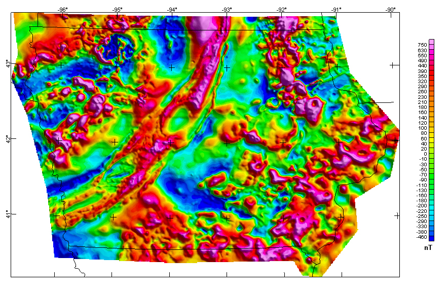
English: Iowa Composite Magnetic Anomaly Map (NE illumination) at simulated flight altitude of 305 m (1,000 ft) above ground |
| Date | (UTC) |
| Source | https://mrdata.usgs.gov/catalog/cite-view.php?cite=64 |
| Author | Kucks, Robert P. and Hill, Patricia L., U.S. Geological Survey |
Licensing edit
This image is in the public domain in the United States because it only contains materials that originally came from the United States Geological Survey, an agency of the United States Department of the Interior. For more information, see the official USGS copyright policy.
|
Original upload log edit
The original description page was here. All following user names refer to en.wikipedia.
| Date/Time | Dimensions | User | Comment |
|---|---|---|---|
| 2009-09-03 20:03 | 884×576× (612399 bytes) | Billwhittaker | {{Information |Description = Iowa Composite Magnetic Anomaly Map (NE illumination) at simulated flight altitude of 305 m (1,000 ft) above ground |Source = http://tin.er.usgs.gov/catalog/cite-view.php?cite=64 |Date = ~~~~~ |Author |
File history
Click on a date/time to view the file as it appeared at that time.
| Date/Time | Thumbnail | Dimensions | User | Comment | |
|---|---|---|---|---|---|
| current | 01:23, 10 January 2017 | | 884 × 576 (598 KB) | BD2412 (talk | contribs) | Transferred from en.wikipedia |
You cannot overwrite this file.
File usage on Commons
The following page uses this file:
File usage on other wikis
The following other wikis use this file:
- Usage on en.wikipedia.org
- Usage on fr.wikipedia.org
- Usage on hy.wikipedia.org
- Usage on it.wikipedia.org
- Usage on ja.wikipedia.org
- Usage on ru.wikipedia.org