File:Ireland rail network sb.svg

Size of this PNG preview of this SVG file: 485 × 599 pixels. Other resolutions: 194 × 240 pixels | 389 × 480 pixels | 622 × 768 pixels | 829 × 1,024 pixels | 1,658 × 2,048 pixels | 2,268 × 2,801 pixels.
Original file (SVG file, nominally 2,268 × 2,801 pixels, file size: 468 KB)
Captions
Captions
Add a one-line explanation of what this file represents
Summary edit
| Description |
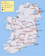
বাংলা: আয়ারল্যান্ডের রেল নেটওয়ার্কের মানচিত্র। English: Map of Rail Networks in Ireland. |
| Date | |
| Source | Derivative Work using Image:Ireland.svg and Image:Ireland rail network.svg |
| Author | Stabilo boss |
| Other versions |
[]
Derivative works of this file: Northern Ireland rail network sb.svg Image:Ireland.svg |

Licensing edit
I, the copyright holder of this work, hereby publish it under the following licenses:
This file is licensed under the Creative Commons Attribution-Share Alike 3.0 Unported license.
- You are free:
- to share – to copy, distribute and transmit the work
- to remix – to adapt the work
- Under the following conditions:
- attribution – You must give appropriate credit, provide a link to the license, and indicate if changes were made. You may do so in any reasonable manner, but not in any way that suggests the licensor endorses you or your use.
- share alike – If you remix, transform, or build upon the material, you must distribute your contributions under the same or compatible license as the original.

|
Permission is granted to copy, distribute and/or modify this document under the terms of the GNU Free Documentation License, Version 1.2 or any later version published by the Free Software Foundation; with no Invariant Sections, no Front-Cover Texts, and no Back-Cover Texts. A copy of the license is included in the section entitled GNU Free Documentation License. |
You may select the license of your choice.
File history
Click on a date/time to view the file as it appeared at that time.
| Date/Time | Thumbnail | Dimensions | User | Comment | |
|---|---|---|---|---|---|
| current | 09:32, 23 September 2019 | | 2,268 × 2,801 (468 KB) | খাঁ শুভেন্দু (talk | contribs) | File uploaded using svgtranslate tool (https://tools.wmflabs.org/svgtranslate/). Added translation for bn. |
| 13:18, 5 May 2018 |  | 2,268 × 2,801 (465 KB) | Blue-Haired Lawyer (talk | contribs) | The Waterford to Wexford is now closed | |
| 11:48, 21 May 2017 |  | 2,268 × 2,801 (458 KB) | Nilfanion (talk | contribs) | Railway not Railroad for Ireland | |
| 20:57, 24 December 2012 |  | 2,268 × 2,801 (458 KB) | RaviC (talk | contribs) | Fix text issue | |
| 15:58, 2 March 2012 |  | 2,268 × 2,801 (458 KB) | Jonto~commonswiki (talk | contribs) | see http://en.wikipedia.org/wiki/Londonderry_railway_station Map was originally based on RoI data but updated with official NI data | |
| 18:42, 20 September 2011 |  | 2,268 × 2,801 (470 KB) | Rwxrwxrwx (talk | contribs) | reverted change to name of derry, see WP:DERRY | |
| 11:52, 1 July 2010 |  | 2,268 × 2,801 (458 KB) | Classical geographer (talk | contribs) | Since March 2010, the southern part of the en:Western Railway Corridor is open. Have changed that from projected (black dash) to current (red). | |
| 01:37, 11 June 2010 |  | 2,268 × 2,801 (458 KB) | Jonto~commonswiki (talk | contribs) | More accurate Antrim and Portadown line. | |
| 00:48, 11 June 2010 |  | 2,268 × 2,801 (457 KB) | Jonto~commonswiki (talk | contribs) | More accurate representation of Northern Ireland network, particularly for Larne line and derry line. More accurate location of airport and defunct line from Lisburn to airport marked as such. | |
| 10:41, 17 September 2008 |  | 2,200 × 2,800 (446 KB) | Stabilo boss (talk | contribs) |
You cannot overwrite this file.
File usage on Commons
The following 19 pages use this file:
- User:Chumwa/OgreBot/Potential transport maps/2017 May 21-31
- User:Chumwa/OgreBot/Potential transport maps/2018 May 1-10
- User:Chumwa/OgreBot/Potential transport maps/2019 September 21-30
- User:Chumwa/OgreBot/Public transport information/2017 May 21-31
- User:Chumwa/OgreBot/Public transport information/2018 May 1-10
- User:Chumwa/OgreBot/Public transport information/2019 September 21-30
- User:Chumwa/OgreBot/Transport Maps/2017 May 21-31
- User:Chumwa/OgreBot/Transport Maps/2018 May 1-10
- User:Chumwa/OgreBot/Transport Maps/2019 September 21-30
- User:Chumwa/OgreBot/Travel and communication maps/2017 May 21-31
- User:Chumwa/OgreBot/Travel and communication maps/2018 May 1-10
- User:Chumwa/OgreBot/Travel and communication maps/2019 September 21-30
- File:Ireland rail network sb.svg
- File:Northern Ireland rail network sb.svg
- Template:Other versions/Ireland rail network sb
- Category:Rail transport in Ireland
- Category:Railway stations in County Armagh
- Category:Railway stations in County Down
- Category:Railway stations in County Londonderry
File usage on other wikis
The following other wikis use this file:
- Usage on ast.wikipedia.org
- Usage on bn.wikipedia.org
- Usage on de.wikipedia.org
- Usage on en.wikipedia.org
- Usage on en.wikivoyage.org
- Usage on es.wikipedia.org
- Usage on fr.wikipedia.org
- Usage on ga.wikipedia.org
- Usage on hu.wikipedia.org
- Usage on it.wikivoyage.org
- Usage on ja.wikipedia.org
- Usage on kab.wikipedia.org
- Usage on kn.wikipedia.org
- Usage on lt.wikipedia.org
- Usage on ru.wikipedia.org
- Usage on sh.wikipedia.org
- Usage on sr.wikipedia.org
- Usage on www.wikidata.org