File:Ireland regions.svg

Size of this PNG preview of this SVG file: 490 × 600 pixels. Other resolutions: 196 × 240 pixels | 392 × 480 pixels | 627 × 768 pixels | 836 × 1,024 pixels | 1,672 × 2,048 pixels | 2,450 × 3,000 pixels.
Original file (SVG file, nominally 2,450 × 3,000 pixels, file size: 3.68 MB)
Captions
Captions
Add a one-line explanation of what this file represents
Summary
edit
| Description |
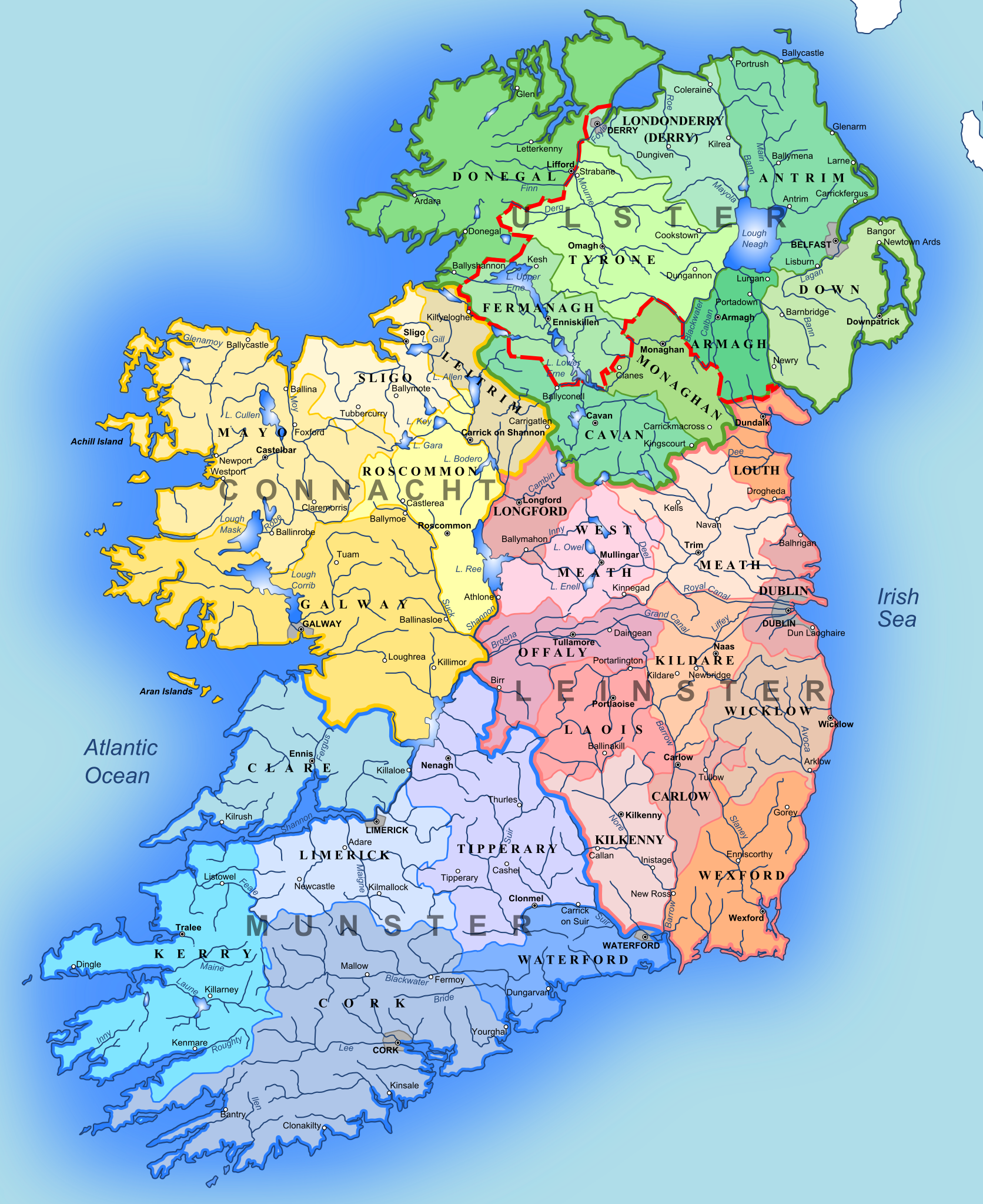
English: A map showing the 4 provinces of Ireland and the traditional Irish counties. Source: Atlas of William Mackenzie (1846) - map of Ireland and own work. |
| Date | |
| Source | Own work |
| Author | Andrein |
Licensing
edit
I, the copyright holder of this work, hereby publish it under the following licenses:
This file is licensed under the Creative Commons Attribution-Share Alike 3.0 Unported license.
- You are free:
- to share – to copy, distribute and transmit the work
- to remix – to adapt the work
- Under the following conditions:
- attribution – You must give appropriate credit, provide a link to the license, and indicate if changes were made. You may do so in any reasonable manner, but not in any way that suggests the licensor endorses you or your use.
- share alike – If you remix, transform, or build upon the material, you must distribute your contributions under the same or compatible license as the original.

|
Permission is granted to copy, distribute and/or modify this document under the terms of the GNU Free Documentation License, Version 1.2 or any later version published by the Free Software Foundation; with no Invariant Sections, no Front-Cover Texts, and no Back-Cover Texts. A copy of the license is included in the section entitled GNU Free Documentation License. |
You may select the license of your choice.
File history
Click on a date/time to view the file as it appeared at that time.
| Date/Time | Thumbnail | Dimensions | User | Comment | |
|---|---|---|---|---|---|
| current | 20:35, 23 September 2010 | | 2,450 × 3,000 (3.68 MB) | ArdadN (talk | contribs) | 1 |
| 21:00, 2 November 2008 |  | 2,450 × 3,000 (3.83 MB) | ArdadN (talk | contribs) | {{Information |Description= |Source= |Date= |Author= |Permission= |other_versions= }} | |
| 01:13, 23 October 2008 |  | 2,450 × 3,000 (3.83 MB) | ArdadN (talk | contribs) | {{Information |Description= |Source= |Date= |Author= |Permission= |other_versions= }} | |
| 01:07, 23 October 2008 |  | 2,450 × 3,000 (3.83 MB) | ArdadN (talk | contribs) | {{Information |Description= |Source= |Date= |Author= |Permission= |other_versions= }} | |
| 00:56, 23 October 2008 |  | 2,450 × 3,000 (3.82 MB) | ArdadN (talk | contribs) | {{Information |Description= |Source= |Date= |Author= |Permission= |other_versions= }} | |
| 00:43, 23 October 2008 |  | 2,450 × 3,000 (3.82 MB) | ArdadN (talk | contribs) | {{Information |Description={{en|1=A map showing the 4 provinces of Ireland and the traditional Irish counties. Source: Atlas of William Mackenzie (1846-copyright expired)- map of Ireland and own work. }} |Source=Own work by uploader |Author=[[User:Andrein |
You cannot overwrite this file.
File usage on Commons
The following page uses this file:
File usage on other wikis
The following other wikis use this file:
- Usage on af.wikipedia.org
- Usage on ca.wikipedia.org
- Irlanda
- Guerra Civil irlandesa
- Alçament de Pasqua
- Estat Lliure d'Irlanda
- Guerra angloirlandesa
- República Irlandesa
- Història d'Irlanda
- Regne d'Irlanda
- Senyoriu d'Irlanda
- Gran fam irlandesa
- Conflicte nord-irlandès
- Colonitzacions d'Irlanda
- Invasió normanda d'Irlanda
- Plantilla:HistòriaIrlanda
- Irlanda celta
- Irlanda normanda
- República de Connacht
- Reconquesta Tudor d'Irlanda
- Irlanda Confederada
- Alçament fenià
- Usage on de.wikipedia.org
- Usage on de.wikibooks.org
- Usage on en.wikipedia.org
- Usage on eu.wikipedia.org
- Usage on fr.wikipedia.org
- Usage on he.wikipedia.org
- Usage on it.wikipedia.org