File:Iron footbridge, Kingswear Station, Dart Estuary - geograph.org.uk - 1535236.jpg
No higher resolution available.
Iron_footbridge,_Kingswear_Station,_Dart_Estuary_-_geograph.org.uk_-_1535236.jpg (640 × 480 pixels, file size: 84 KB, MIME type: image/jpeg)
Captions
Captions
Add a one-line explanation of what this file represents
Summary
edit
| Description |
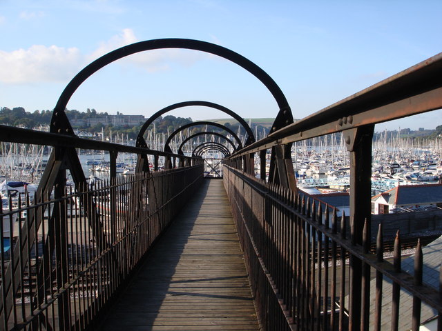
English: Iron footbridge, Kingswear Station, Dart Estuary The iron footbridge enables pedestrians to get down from the road to the railway station and the marina. There is also a footpath which runs alongside the railway track to the upper ferry. In this image, the Britannia Royal Naval College on the Dartmouth side is framed on the left by the curved iron arch spanning the footbridge. The eye is led into the heart of the sea of yachts in the marina below. |
| Date | |
| Source | From geograph.org.uk |
| Author | Tom Jolliffe |
| Attribution (required by the license) | Tom Jolliffe / Iron footbridge, Kingswear Station, Dart Estuary / |
| Camera location | | View this and other nearby images on: OpenStreetMap |
|---|
_heading:315.00&language=en)
| Object location | | View this and other nearby images on: OpenStreetMap |
|---|
_heading:315.00&language=en)
Licensing
edit

|
This image was taken from the Geograph project collection. See this photograph's page on the Geograph website for the photographer's contact details. The copyright on this image is owned by Tom Jolliffe and is licensed for reuse under the Creative Commons Attribution-ShareAlike 2.0 license.
|
This file is licensed under the Creative Commons Attribution-Share Alike 2.0 Generic license.
Attribution: Tom Jolliffe
- You are free:
- to share – to copy, distribute and transmit the work
- to remix – to adapt the work
- Under the following conditions:
- attribution – You must give appropriate credit, provide a link to the license, and indicate if changes were made. You may do so in any reasonable manner, but not in any way that suggests the licensor endorses you or your use.
- share alike – If you remix, transform, or build upon the material, you must distribute your contributions under the same or compatible license as the original.
File history
Click on a date/time to view the file as it appeared at that time.
| Date/Time | Thumbnail | Dimensions | User | Comment | |
|---|---|---|---|---|---|
| current | 06:44, 3 March 2011 | | 640 × 480 (84 KB) | GeographBot (talk | contribs) | == {{int:filedesc}} == {{Information |description={{en|1=Iron footbridge, Kingswear Station, Dart Estuary The iron footbridge enables pedestrians to get down from the road to the railway station and the marina. There is also a footpath which runs alongsid |
You cannot overwrite this file.
File usage on Commons
There are no pages that use this file.