File:Islamic City of Balat (Balat Old City), Dakhhla Oasis in Egypt 233.jpg

Size of this preview: 450 × 600 pixels. Other resolutions: 180 × 240 pixels | 360 × 480 pixels | 576 × 768 pixels | 768 × 1,024 pixels | 1,536 × 2,048 pixels.
Original file (1,536 × 2,048 pixels, file size: 878 KB, MIME type: image/jpeg)
Captions
Captions
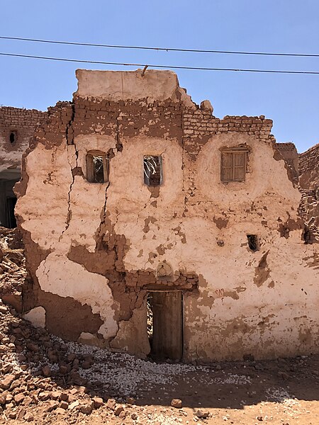
Islamic City of Balat (Balat Old City), Dakhhla Oasis in Egypt
Summary
edit,_Dakhhla_Oasis_in_Egypt_233.jpg&action=edit§ion=1)
| Description |
English: Islamic City of Balat (Balat Old City), Dakhhla Oasis in Egypt It is a itegrated archaeological city datig back to the Ottoma era. It was built i a high place to avoid the dager of udergroud water, to adapt to the extreme heat of the cotietal weather, ad also to defed the city agaist the attacks of its eemies. This ame was amed because it was the seat of the royal court durig the Ottoma period . The city icludes may religious ad civil buildigs such as mosques, kateebas ad houses cosistig of oe or two or three floors. It also icluded may service buildigs such as mills, jugs, ports ad shops. (A quote: https://egyptian-antiquities.com/en/%D9%85%D8%AF%D9%8A%D9%86%D8%A9-%D8%A8%D9%84%D8%A7%D8%B7-%D8%A7%D9%84%D8%A5%D8%B3%D9%84%D8%A7%D9%85%D9%8A%D8%A9/) |
| Date | |
| Source | Adligat, Belgrade (Viktor Lazić) |
| Author | Viktor Lazić |
| Permission (Reusing this file) |
| Camera location | | View this and other nearby images on: OpenStreetMap |
|---|
,_Dakhhla_Oasis_in_Egypt_233.jpg¶ms=025.560728_N_0029.264853_E_globe:Earth_type:camera_heading:118.74&language=en)
Ова датотека је донација Адлигат, у оквиру програма стажирања реализованог од стране Викимедије Србије. This file is donated by the Adligat, as part of the Wikipedian in Residence program implemented by Wikimedia Serbia. |
Licensing
edit,_Dakhhla_Oasis_in_Egypt_233.jpg&action=edit§ion=2)
This file is licensed under the Creative Commons Attribution-Share Alike 4.0 International license.
- You are free:
- to share – to copy, distribute and transmit the work
- to remix – to adapt the work
- Under the following conditions:
- attribution – You must give appropriate credit, provide a link to the license, and indicate if changes were made. You may do so in any reasonable manner, but not in any way that suggests the licensor endorses you or your use.
- share alike – If you remix, transform, or build upon the material, you must distribute your contributions under the same or compatible license as the original.
File history
Click on a date/time to view the file as it appeared at that time.
| Date/Time | Thumbnail | Dimensions | User | Comment | |
|---|---|---|---|---|---|
| current | 12:35, 31 July 2023 | | 1,536 × 2,048 (878 KB) | Корак по корак (talk | contribs) | Uploaded a work by Viktor Lazić from Adligat, Belgrade (Viktor Lazić) with UploadWizard |
You cannot overwrite this file.
File usage on Commons
There are no pages that use this file.
,_Dakhhla_Oasis_in_Egypt_233.jpg&oldid=898727586)