File:Islands Northwest Of Waiheke Island (cropped).jpg

Size of this preview: 800 × 473 pixels. Other resolutions: 320 × 189 pixels | 640 × 378 pixels | 1,024 × 606 pixels | 1,302 × 770 pixels.
Original file (1,302 × 770 pixels, file size: 601 KB, MIME type: image/jpeg)
Captions
Captions
Add a one-line explanation of what this file represents
Summary edit
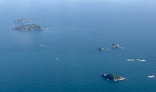
| Description |
English: The Noises island group: Motuhoropapa Island (top left), Otata Island (top left, slightly lower) and Maria Island (lower right) in the Hauraki Gulf, New Zealand. Looking northeastwards. |
| Date | |
| Source | Self-photographed |
| Author | Ingolfson |
| Other versions |

.jpg&action=edit§ion=1)
| Camera location | | View this and other nearby images on: OpenStreetMap |
|---|
.jpg¶ms=-36.853192_N_0174.771232_E_globe:Earth_type:camera__&language=en)
Licensing edit
.jpg&action=edit§ion=2)
| I, the copyright holder of this work, release this work into the public domain. This applies worldwide. In some countries this may not be legally possible; if so: I grant anyone the right to use this work for any purpose, without any conditions, unless such conditions are required by law. |
File history
Click on a date/time to view the file as it appeared at that time.
| Date/Time | Thumbnail | Dimensions | User | Comment | |
|---|---|---|---|---|---|
| current | 07:41, 2 September 2021 | | 1,302 × 770 (601 KB) | Giantflightlessbirds (talk | contribs) | File:Islands Northwest Of Waiheke Island.jpg cropped 19 % horizontally, 36 % vertically using CropTool with precise mode. |
You cannot overwrite this file.
File usage on Commons
The following 2 pages use this file:
File usage on other wikis
The following other wikis use this file:
- Usage on ceb.wikipedia.org
- Usage on de.wikipedia.org
- Usage on en.wikipedia.org
- Usage on www.wikidata.org
.jpg&oldid=588090515)