File:IsleDeMontreal1764.png

Size of this preview: 800 × 468 pixels. Other resolutions: 320 × 187 pixels | 640 × 374 pixels | 1,024 × 599 pixels | 1,447 × 846 pixels.
Original file (1,447 × 846 pixels, file size: 1.98 MB, MIME type: image/png)
Captions
Captions
Add a one-line explanation of what this file represents
Summary
edit
| Description |
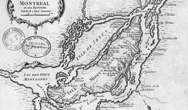
English: This is a detail of the original source map, cropped to depict primarily the Isle of Montreal and immediately surrounding mainland. The map's caption reads "Montreal et ses Environs" (Montreal and its environs). |
| Date | |
| Source | Bibliothèque Nationale de France http://gallica2.bnf.fr/ark:/12148/btv1b67001778 |
| Author | Bellin, Jacques-Nicolas, for the Kingdom of France |
Licensing
edit
This media file is in the public domain in the United States. This applies to U.S. works where the copyright has expired, often because its first publication occurred prior to January 1, 1929, and if not then due to lack of notice or renewal. See this page for further explanation.
|
 | |
 |
This image might not be in the public domain outside of the United States; this especially applies in the countries and areas that do not apply the rule of the shorter term for US works, such as Canada, Mainland China (not Hong Kong or Macao), Germany, Mexico, and Switzerland. The creator and year of publication are essential information and must be provided. See Wikipedia:Public domain and Wikipedia:Copyrights for more details.
|
File history
Click on a date/time to view the file as it appeared at that time.
| Date/Time | Thumbnail | Dimensions | User | Comment | |
|---|---|---|---|---|---|
| current | 00:42, 11 January 2009 | | 1,447 × 846 (1.98 MB) | Magicpiano (talk | contribs) | {{Information |Description={{en|1=This is a detail of the original source map, cropped to depict primarily the Isle of Montreal and immediately surrounding mainland. The map's caption reads "Montreal et ses Environs" (Montreal and its environs).}} |Sourc |
You cannot overwrite this file.
File usage on Commons
The following page uses this file:
File usage on other wikis
The following other wikis use this file:
- Usage on en.wikipedia.org
- Usage on fr.wikipedia.org
- Usage on it.wikipedia.org
- Usage on ja.wikipedia.org
- Usage on www.wikidata.org
- Usage on zh.wikipedia.org