File:Isole della Grecia.svg

Size of this PNG preview of this SVG file: 729 × 600 pixels. Other resolutions: 292 × 240 pixels | 584 × 480 pixels | 934 × 768 pixels | 1,245 × 1,024 pixels | 2,490 × 2,048 pixels | 1,003 × 825 pixels.
Original file (SVG file, nominally 1,003 × 825 pixels, file size: 778 KB)
Captions
Captions
Add a one-line explanation of what this file represents
Summary edit
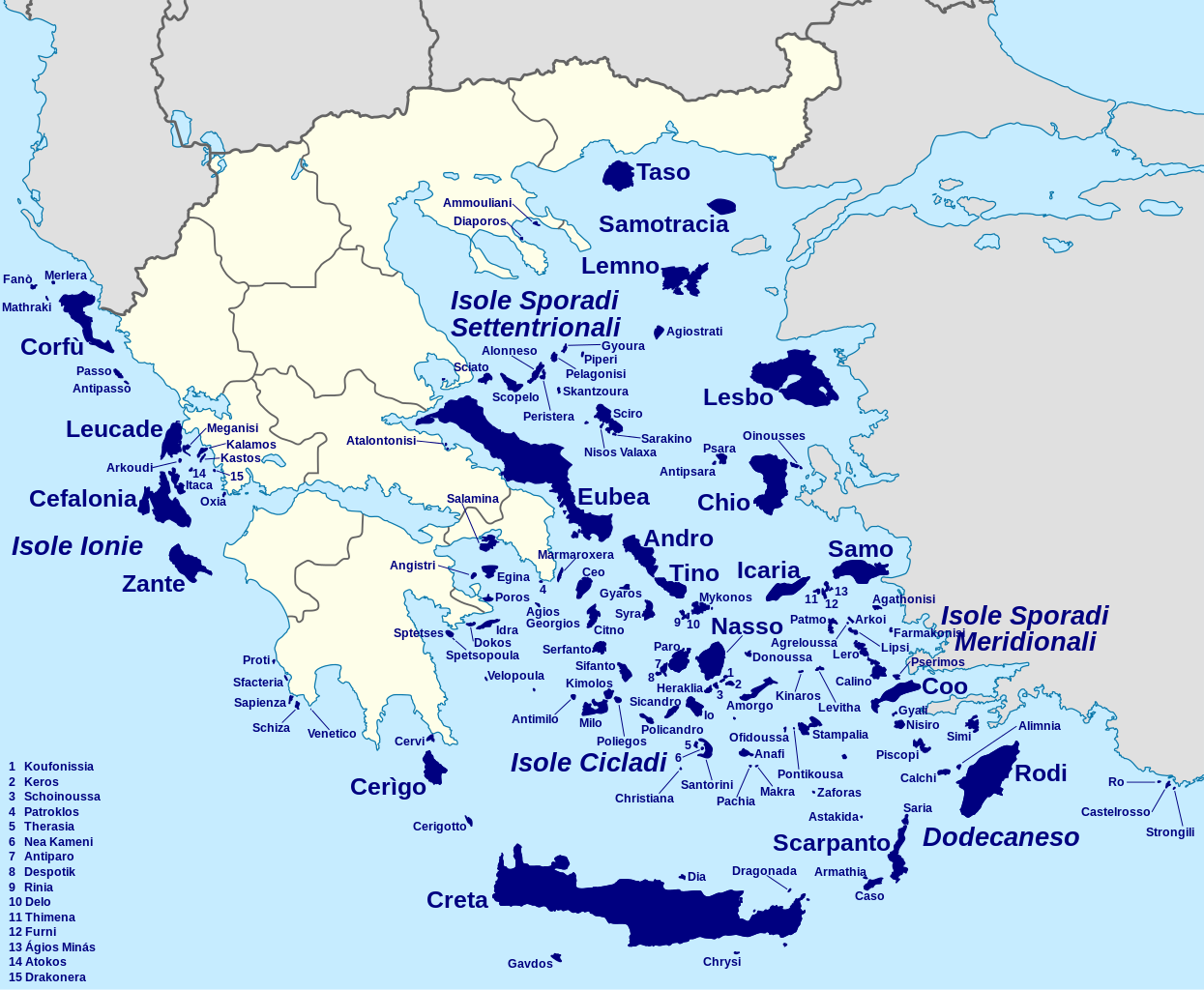
| Description |
Italiano: Mappa delle isole greche |
| Date | (UTC) |
| Source |
This file was derived from: Greece location map.svg: |
| Author |
|
| Other versions |
|


| This is a retouched picture, which means that it has been digitally altered from its original version. The original can be viewed here: Greece location map.svg:
|
Licensing edit
I, the copyright holder of this work, hereby publish it under the following licenses:
This file is licensed under the Creative Commons Attribution-Share Alike 3.0 Unported license.
- You are free:
- to share – to copy, distribute and transmit the work
- to remix – to adapt the work
- Under the following conditions:
- attribution – You must give appropriate credit, provide a link to the license, and indicate if changes were made. You may do so in any reasonable manner, but not in any way that suggests the licensor endorses you or your use.
- share alike – If you remix, transform, or build upon the material, you must distribute your contributions under the same or compatible license as the original.

|
Permission is granted to copy, distribute and/or modify this document under the terms of the GNU Free Documentation License, Version 1.2 or any later version published by the Free Software Foundation; with no Invariant Sections, no Front-Cover Texts, and no Back-Cover Texts. A copy of the license is included in the section entitled GNU Free Documentation License. |
You may select the license of your choice.
Original upload log edit
This image is a derivative work of the following images:
- File:Greece_location_map.svg licensed with Cc-by-sa-3.0, GFDL
- 2010-12-18T22:33:55Z Pitichinaccio 1003x825 (688831 Bytes) Prefecture borders removed. The prefectures of Greece were suppressed in 2010. Präfekturgrenzen entfernt. Die griechischen Präfekturen wurde 2010 abgeschafft.
- 2008-09-11T16:28:02Z Lencer 1003x825 (852751 Bytes) {{Information |Description= |Source= |Date= |Author= |Permission= |other_versions= }}
- 2008-08-16T12:13:31Z Lencer 1003x825 (838049 Bytes) {{Information |Description= |Source= |Date= |Author= |Permission= |other_versions= }}
- 2008-07-23T18:26:04Z Lencer 869x715 (842748 Bytes) {{Information |Description= |Source= |Date= |Author= |Permission= |other_versions= }}
- 2008-07-23T18:11:37Z Lencer 869x715 (842814 Bytes) {{Information |Description= {{de|Positionskarte von [[:de:Griechenland|Griechenland]]}} Quadratische Plattkarte, N-S-Streckung 120 %. Geographische Begrenzung der Karte: * N: 42.0° N * S: 34.6° N * W: 19.1° O * O: 2
Uploaded with derivativeFX
File history
Click on a date/time to view the file as it appeared at that time.
| Date/Time | Thumbnail | Dimensions | User | Comment | |
|---|---|---|---|---|---|
| current | 11:53, 20 October 2012 | | 1,003 × 825 (778 KB) | Yiyi (talk | contribs) | + dettagli |
| 20:28, 19 October 2012 |  | 1,003 × 825 (727 KB) | Yiyi (talk | contribs) | == {{int:filedesc}} == {{Information |Description={{it|Mappa delle isole greche}} |Source={{Derived from|Greece_location_map.svg|display=50}} |Date=2012-10-19 20:27 (UTC) |Author=*File:Greece_location_map.svg: ... |
You cannot overwrite this file.
File usage on Commons
The following 2 pages use this file:
File usage on other wikis
The following other wikis use this file:
- Usage on gl.wikipedia.org
- Usage on he.wikivoyage.org
- Usage on it.wikipedia.org