File:Israelmap001.jpg

Size of this preview: 327 × 599 pixels. Other resolutions: 131 × 240 pixels | 450 × 824 pixels.
Original file (450 × 824 pixels, file size: 41 KB, MIME type: image/jpeg)
Captions
Captions
Add a one-line explanation of what this file represents
Summary
edit
| Description |
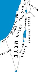
אזורים בארץ ישראל Holy Land regions -- Galilee, Bashan, plain of Sharon, Judea, Negev, Gilead, Moab, Edom, Paran, etc. |
| Source | ויקיפדיה העברית |
| Author | משתמש:Yanivreg |
Licensing
edit

|
Permission is granted to copy, distribute and/or modify this document under the terms of the GNU Free Documentation License, Version 1.2 or any later version published by the Free Software Foundation; with no Invariant Sections, no Front-Cover Texts, and no Back-Cover Texts. A copy of the license is included in the section entitled GNU Free Documentation License. |
| This file is licensed under the Creative Commons Attribution-Share Alike 3.0 Unported license. | ||
| ||
| This licensing tag was added to this file as part of the GFDL licensing update. |
File history
Click on a date/time to view the file as it appeared at that time.
| Date/Time | Thumbnail | Dimensions | User | Comment | |
|---|---|---|---|---|---|
| current | 13:58, 21 February 2008 | | 450 × 824 (41 KB) | שמופי~commonswiki (talk | contribs) | {{Information |Description=אזורים בארץ ישראל |ויקיפדיה העבריתSource= |Date= |Author=משתמש:Yanivreg |Permission= |other_versions= }} |
You cannot overwrite this file.
File usage on Commons
The following page uses this file:
.png)
File usage on other wikis
The following other wikis use this file:
- Usage on he.wikipedia.org
- היסטוריה של ארץ ישראל
- גאוגרפיה של ארץ ישראל
- הרי אילת
- מישור החוף
- גוש דן
- רמת הגולן
- מדבר יהודה
- הגליל
- הרי אדום
- עמק החולה
- בקעת הירדן
- עבר הירדן
- עמק יזרעאל
- הכרמל
- הגליל התחתון
- השומרון
- שפלת יהודה
- הגלעד
- יהודה (חבל ארץ)
- חבל אשכול
- הערבה
- השרון
- אצבע הגליל
- עמק בית שאן
- שיחת קובץ:Israelmap001.jpg
- ארץ כינרות
- הבשן
- הנגב
- הר הנגב
- חורן
- מישור החוף הצפוני
- מישור החוף הדרומי
- מכתשים בנגב
- הרי בנימין
- משתמש:ThE OnE
- מישור חוף יהודה
- תבנית:אזורים בארץ ישראל
- הר חרמון
- מישור חוף הכרמל
- הגליל המערבי
- הבקע הסורי-אפריקני
- הגליל העליון
- שיחת תבנית:שמורות טבע בישראל
- בקעת ים המלח
- טרכון
- ארגוב (אתר מקראי)
- מצפה גלעד
- שיחה:באר לחי ראי
- מנחת (אתר מקראי)
- אלון מורה (אתר מקראי)
View more global usage of this file.