File:Iss040e039331.jpeg

Size of this preview: 800 × 532 pixels. Other resolutions: 320 × 213 pixels | 640 × 426 pixels | 1,024 × 681 pixels | 1,280 × 851 pixels | 2,560 × 1,703 pixels | 4,312 × 2,868 pixels.
Original file (4,312 × 2,868 pixels, file size: 13.64 MB, MIME type: image/jpeg)
Captions
Captions
Add a one-line explanation of what this file represents
Summary edit
| Camera location | | View this and other nearby images on: OpenStreetMap |
|---|
| Description |
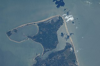
English: USA-MASSACHUSETTS, CHAPPAQUIDDICK I., EDGARTOWN, CAPE PAGE B., KATAMA B., EDGARTOWN HARBOR |
| Date | |
| Source | http://eol.jsc.nasa.gov/SearchPhotos/photo.pl?mission=ISS040&roll=E&frame=39331 |
| Author |
English: NASA |
Licensing edit
| This file is in the public domain in the United States because it was solely created by NASA. NASA copyright policy states that "NASA material is not protected by copyright unless noted". (See Template:PD-USGov, NASA copyright policy page or JPL Image Use Policy.) | ||
 |
Warnings:
|
File history
Click on a date/time to view the file as it appeared at that time.
| Date/Time | Thumbnail | Dimensions | User | Comment | |
|---|---|---|---|---|---|
| current | 09:50, 24 June 2015 | | 4,312 × 2,868 (13.64 MB) | NasaEolBot (talk | contribs) | =={{int:filedesc}}== {{Location|41.4|-70.5}} {{Information |description={{en|USA-MASSACHUSETTS, CHAPPAQUIDDICK I., EDGARTOWN, CAPE PAGE B., KATAMA B., EDGARTOWN HARBOR}} |date=2014-07-05 00:00:00 |source=http://eol.jsc.nasa.gov/SearchPhotos/photo.pl?mi... |
You cannot overwrite this file.
File usage on Commons
There are no pages that use this file.