File:Istočna Slavonija, Baranja i Zapadni Srem-sr.png

Size of this preview: 411 × 599 pixels. Other resolutions: 164 × 240 pixels | 329 × 480 pixels | 881 × 1,285 pixels.
Original file (881 × 1,285 pixels, file size: 92 KB, MIME type: image/png)
Captions
Captions
Add a one-line explanation of what this file represents
Summary
edit
| Description |
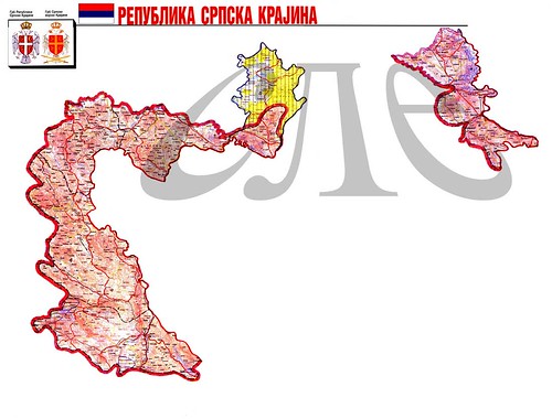
English: Map of the Eastern Slavonia, Baranja and Western Srem - Serbian language version.
Српски / srpski: Мапа Источне Словоније, Барање и Западног Срема - верзија на српском језику. |
| Date | |
| Source |
Translation of English-language image from commons Srem_baranja.png http://commons.wikimedia.org/wiki/File:Srem_baranja.png (author of that image is User:PANONIAN) |
| Author | User:PANONIAN (original map), User:Iricigor (translated version) |
| Other versions | http://commons.wikimedia.org/wiki/File:Srem_baranja.png |
Licensing
edit
| I, the copyright holder of this work, release this work into the public domain. This applies worldwide. In some countries this may not be legally possible; if so: I grant anyone the right to use this work for any purpose, without any conditions, unless such conditions are required by law. |
References
edit
- Sve srpske mape - od šestog veka do Pariza, Specijalno izdanje BLICA, Decembar 1995
- Dr Tomislav Bogavac, Nestajanje Srba, Niš, 1994.
- Miodrag Milošević, Geografija za 8. razred osnovne škole, Beograd, 1994.
- Dragan Rodić, Geografija za I ili III razred srednje škole, Beograd, 1995.
- Istorijski atlas, Geokarta, Beograd, 1999.
- Richard Overy, The Times History of the 20th Century, Times Books, London, 2004.
- The Times History of Europe, Times Books, London, 2002.
- Slavko Vejinović, Srbi u dijaspori u prošlosti i sadašnjosti, Novi Sad, 1999.
- Tim Džuda, Srbi - istorija, mit i razaranje Jugoslavije, Beograd, 2003.
- Džon R. Lempi, Jugoslavija kao istorija, Beograd, 2004.
- Nada Miletić Stanić, Pravoslavne crkve u Baranji, Novi Sad, 1999.
- http://web.ku.edu/~eceurope/hist557/lect20_files/yugoslavprovinces.jpg archive copy at the Wayback Machine
- http://terkepek.adatbank.transindex.ro/kepek/netre/292.gif
- http://www.pointernet.pds.hu/touristinfo/croatia/image/g.jpg archive copy at the Wayback Machine
- http://clip2net.com/clip/m6499/1217833413-krajina_army_territorial_division-jpg-34kb.jpg
- http://profile.ak.fbcdn.net/hprofile-ak-snc4/50514_294052851171_2302284_n.jpg archive copy at the Wayback Machine
- http://www.vecernji.hr/slika-500x329/vijesti/otkrivamo-britanci-trazili-da-baranju-dio-istocne-slavonije-predamo-srbiji-slika-85519[dead link]
- http://www.srpskapolitika.com/krajina/mapa211.jpg archive copy at the Wayback Machine
- http://www.srpska-mreza.com/MAPS/Ethnic-groups/map-UN-1994.jpg
- http://www.srpskapolitika.com/krajina/etnicka_karta.jpg archive copy at the Wayback Machine
- http://www.srpskapolitika.com/krajina/mapa311.jpg archive copy at the Wayback Machine
- http://farm1.static.flickr.com/45/110412384_09ffb827cb.jpg
File history
Click on a date/time to view the file as it appeared at that time.
| Date/Time | Thumbnail | Dimensions | User | Comment | |
|---|---|---|---|---|---|
| current | 10:34, 4 August 2011 | | 881 × 1,285 (92 KB) | WikiEditor2004 (talk | contribs) | improved version, like in original English-language file |
| 21:00, 27 December 2008 |  | 700 × 1,084 (52 KB) | Iricigor (talk | contribs) | {{Information |Description={{en|1=Map of the Eastern Slavonia, Baranja and Western Srem}} {{sr|1=Мапа Источне Словоније, Барање и Западног Срема}} |Source=Based on image from commons Srem_baranja.png http://commons |
You cannot overwrite this file.
File usage on Commons
The following page uses this file:
- File:Srem baranja-srpski.png (file redirect)
File usage on other wikis
The following other wikis use this file:
- Usage on ru.wikipedia.org
- Usage on sr.wikipedia.org