File:Iwate - Miyako - Taro-Mukaishinden -a- Tsunami height -b- View of damage -c- The survey point where the tsunami runup height of 37,8 m was measured.jpg

Size of this preview: 727 × 599 pixels. Other resolutions: 291 × 240 pixels | 582 × 480 pixels | 932 × 768 pixels | 1,242 × 1,024 pixels | 2,069 × 1,706 pixels.
Original file (2,069 × 1,706 pixels, file size: 691 KB, MIME type: image/jpeg)
Captions
Captions
Add a one-line explanation of what this file represents
Summary
edit
| Description |
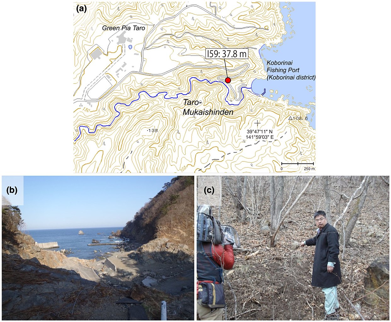
English: Source: Yoshinobu Tsuji, Kenji Satake, Takeo Ishibe, Tomoya Harada, Akihito Nishiyama, Satoshi Kusumoto: "Tsunami Heights along the Pacific Coast of Northern Honshu Recorded from the 2011 Tohoku", Pure and Applied Geophysics, 171, 12, (2014), pp. 3183–3215, DOI:10.1007/s00024-014-0779-x, online published on 19 March 2014. License: Creative Commons Attribution 4.0 International (CC BY 4.0). Here p. 3188, Figure 5.
Caption as given in the above cited source: "Figure 5 - a Tsunami height at Taro-Mukaishinden, Miyako City, Iwate Prefecture. The symbol and its meaning are the same as in Fig. 3. b View of tsunami damage at Taro-Mukaishinden. The white pole in the lower-right of the picture was bent by the tsunami. c The survey point where the largest tsunami runup height of 37.8 m in our field surveys was measured"
|
| Date | |
| Source | Yoshinobu Tsuji, Kenji Satake, Takeo Ishibe, Tomoya Harada, Akihito Nishiyama, Satoshi Kusumoto: "Tsunami Heights along the Pacific Coast of Northern Honshu Recorded from the 2011 Tohoku", Pure and Applied Geophysics, 171, 12, (2014), pp. 3183–3215, DOI:10.1007/s00024-014-0779-x, online published on 19 March 2014. License: Creative Commons Attribution 4.0 International (CC BY 4.0). Here p. 3188, Figure 5. |
| Author | Yoshinobu Tsuji, Kenji Satake, Takeo Ishibe, Tomoya Harada, Akihito Nishiyama, Satoshi Kusumoto: "Tsunami Heights along the Pacific Coast of Northern Honshu Recorded from the 2011 Tohoku", Pure and Applied Geophysics, 171, 12, (2014), pp. 3183–3215, DOI:10.1007/s00024-014-0779-x, online published on 19 March 2014. License: Creative Commons Attribution 4.0 International (CC BY 4.0). Here p. 3188, Figure 5. |
| Permission (Reusing this file) |
This file is licensed under the Creative Commons Attribution 4.0 International license.
|
Licensing
edit
This file is licensed under the Creative Commons Attribution 4.0 International license.
- You are free:
- to share – to copy, distribute and transmit the work
- to remix – to adapt the work
- Under the following conditions:
- attribution – You must give appropriate credit, provide a link to the license, and indicate if changes were made. You may do so in any reasonable manner, but not in any way that suggests the licensor endorses you or your use.
File history
Click on a date/time to view the file as it appeared at that time.
| Date/Time | Thumbnail | Dimensions | User | Comment | |
|---|---|---|---|---|---|
| current | 11:31, 16 August 2018 | | 2,069 × 1,706 (691 KB) | Anglo-Araneophilus~commonswiki (talk | contribs) | {{Information |description ={{en|1=Source: Yoshinobu Tsuji, Kenji Satake, Takeo Ishibe, Tomoya Harada, Akihito Nishiyama, Satoshi Kusumoto: "Tsunami Heights along the Pacific Coast of Northern Honshu Recorded from the 2011 Tohoku", Pure and Applied Geophysics, 171, 12, (2014), pp. 3183–3215, DOI:10.1007/s00024-014-0779-x, online published on 19 March 2014. License: Creative Commons Attribution 4.0 International (CC BY 4.0). Here p. 3188, Figure 5. Caption as given in the above cited source... |
You cannot overwrite this file.
File usage on Commons
There are no pages that use this file.
File usage on other wikis
The following other wikis use this file:
- Usage on de.wikipedia.org