File:JMA Surface Analysis Chart 01-05-2017 18Z.png
Original file (3,004 × 2,097 pixels, file size: 2.14 MB, MIME type: image/png)
Captions
Captions
Summary
edit| Description |
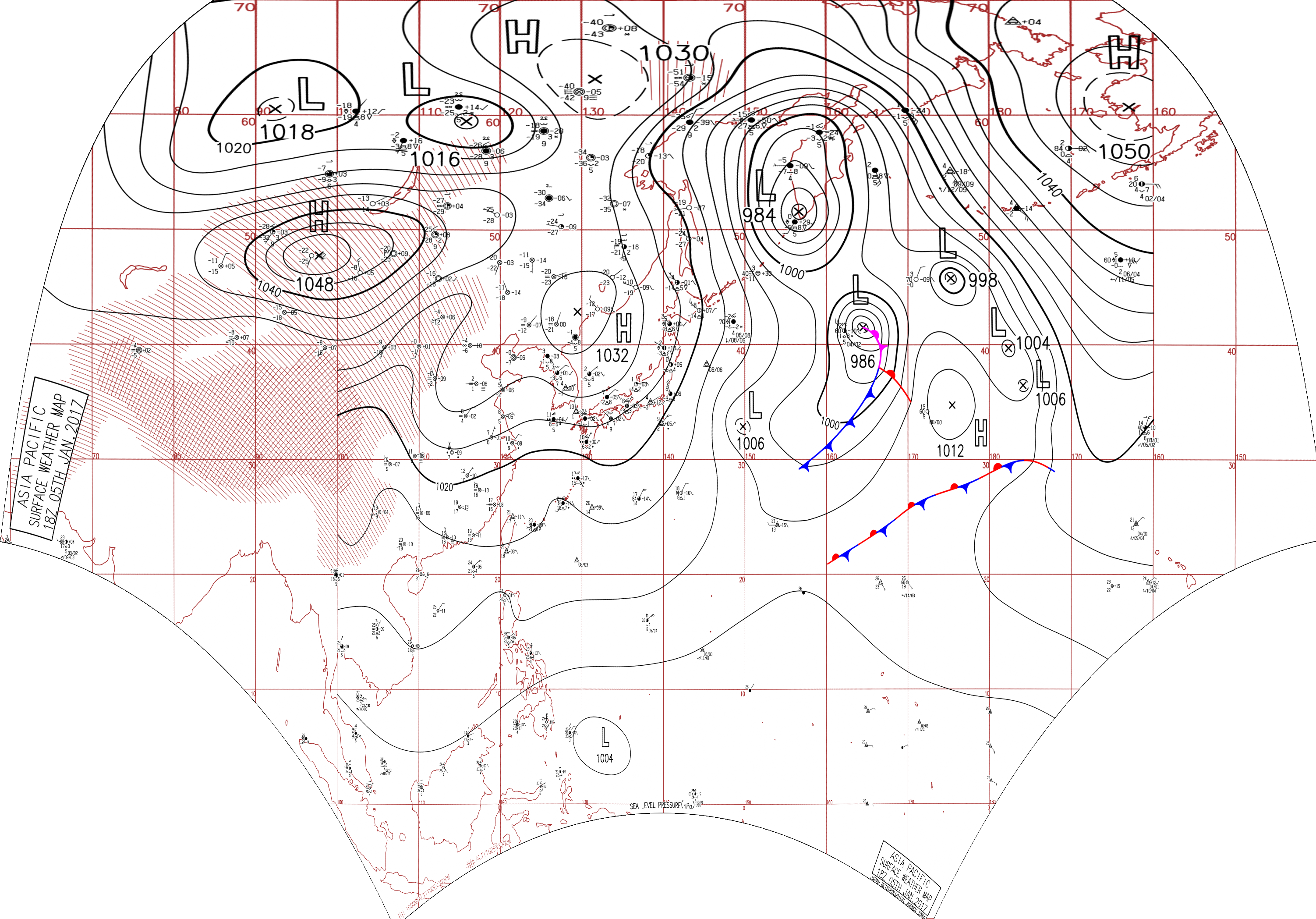
English: Surface analysis chart of Metarea XI for 5 January 2017, 18Z. Product of the Japan Meteorological Agency.
WWJP25 RJTD 051800 WARNING AND SUMMARY 051800. WARNING VALID 061800. WARNING IS UPDATED EVERY 6 HOURS. STORM WARNING. DEVELOPING LOW 988 HPA AT 41N 164E FAR OFF EAST OF JAPAN MOVING NORTHNORTHEAST 30 KNOTS. OCCLUDED FRONT FROM 41N 164E TO 41N 165E 39N 166E. WARM FRONT FROM 39N 166E TO 37N 168E 34N 169E. COLD FRONT FROM 39N 166E TO 35N 165E 30N 159E. WINDS 30 TO 50 KNOTS WITHIN 400 MILES OF LOW SOUTHEAST SEMICIRCLE AND 200 MILES ELSEWHERE. FORECAST POSITION FOR 060600UTC AT 47N 165E WITH UNCERTAINTY OF 50 MILES RADIUS. FORECAST POSITION FOR 061800UTC AT 50N 163E WITH UNCERTAINTY OF 85 MILES RADIUS. GALE WARNING. DEVELOPING LOW 1006 HPA AT 33N 150E SEA EAST OF JAPAN MOVING SOUTHEAST 20 KNOTS. WINDS 30 TO 40 KNOTS WITHIN 900 MILES OF LOW WEST SEMICIRCLE AND 400 MILES ELSEWHERE. GALE WARNING. DEVELOPED LOW 984 HPA AT 52N 157E KAMCHATKA ALMOST STATIONARY. WINDS 30 TO 40 KNOTS WITHIN 900 MILES OF LOW EAST SEMICIRCLE AND 600 MILES ELSEWHERE. GALE WARNING. DEVELOPED LOW 998 HPA AT 44N 176E SEA SOUTH OF ALEUTIANS MOVING NORTHNORTHWEST 15 KNOTS. WINDS 30 TO 40 KNOTS WITHIN 800 MILES OF LOW SOUTHEAST SEMICIRCLE AND 300 MILES ELSEWHERE. ANOTHER LOW 1004 HPA AT 39N 177W MOVING NORTHNORTHEAST 10 KNOTS. WARNING. DENSE FOG OBSERVED LOCALLY OVER YELLOW SEA EAST CHINA SEA NORTHERN PART OF SOUTH CHINA SEA. WARNING. DENSE FOG OBSERVED LOCALLY OVER WATERS BOUNDED BY 55N 165E 60N 165E 60N 170E 50N 180E 42N 180E 47N 170E 55N 165E. SUMMARY. LOW PRESSURE AREA 1004 HPA NEAR 05N 133E WEST SLOWLY. HIGH 1032 HPA AT 43N 129E SE 15 KT. HIGH 1012 HPA AT 35N 175E ENE 10 KT. STATIONARY FRONT FROM 26N 111E TO 30N 118E 28N 128E. STATIONARY FRONT FROM 20N 160E TO 24N 170E 29N 180E.
|
| Date | |
| Source | Japan Meteorological Agency weather chart page |
| Author | Based on "Surface Analysis Chart" (Japan Meteorological Agency) |
Licensing
editThis image was produced by the Japan Meteorological Agency. The legal notice (archive) stated that all the images published on their website is compatible with the Creative Commons Attribution 4.0 License, which means that all the images on this website is published under the Creative Commons Attribution 4.0 License unless otherwise specified.
This file is licensed under the Creative Commons Attribution 4.0 International license. Attribution: Japan Meteorological Agency
|
 |

File history
Click on a date/time to view the file as it appeared at that time.
| Date/Time | Thumbnail | Dimensions | User | Comment | |
|---|---|---|---|---|---|
| current | 07:30, 24 August 2017 | | 3,004 × 2,097 (2.14 MB) | Supportstorm (talk | contribs) | Reanalysis |
| 05:25, 9 August 2017 |  | 2,500 × 1,614 (2.11 MB) | Supportstorm (talk | contribs) | =={{int:filedesc}}== {{Information |description={{en|1=Surface analysis chart of Metarea XI for 5 January 2017, 18Z. Product of the Japan Meteorological Agency.}} WWJP25 RJTD 051800 WARNING AND SUMMARY 051800. WARNING VALID 061800. WARNING IS UPDATE... |
You cannot overwrite this file.
File usage on Commons
There are no pages that use this file.