File:JMA Surface Analysis Chart 08-06-2017 00Z.png
Original file (2,500 × 1,614 pixels, file size: 1.93 MB, MIME type: image/png)
Captions
Captions
Summary
edit| Description |
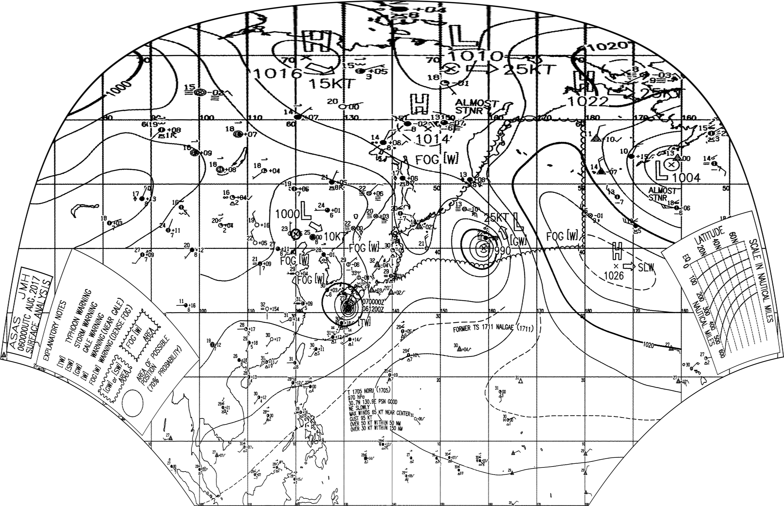
English: Surface analysis chart of Metarea XI for 6 August 2017, 00Z. Product of the Japan Meteorological Agency.
WWJP25 RJTD 060000 WARNING AND SUMMARY 060000. WARNING VALID 070000. WARNING IS UPDATED EVERY 6 HOURS. GALE WARNING. DEVELOPING LOW FORMER TROPICAL STORM 1711 NALGAE (1711) 990 HPA AT 40N 159E FAR OFF EAST OF JAPAN MOVING NORTHNORTHWEST 25 KNOTS. WINDS 30 TO 45 KNOTS WITHIN 300 MILES OF LOW. WARNING. DENSE FOG OBSERVED LOCALLY OVER SEA OF OKHOTSK SEA OF JAPAN BOHAI YELLOW SEA. WARNING. DENSE FOG OBSERVED LOCALLY OVER WATERS BOUNDED BY 35N 140E 40N 142E 42N 140E 46N 151E 51N 157E 60N 164E 60N 180E 40N 180E 37N 159E 38N 148E 35N 142E 35N 140E. SUMMARY. LOW 1000 HPA AT 42N 120E ESE 10 KT. HIGH 1014 HPA AT 59N 147E ALMOST STATIONARY. REMARKS. TYPHOON 1705 NORU (1705) 970 HPA AT 30.7N 130.9E : SEE TROPICAL CYCLONE WARNING.
|
| Date | |
| Source | Japan Meteorological Agency weather chart page |
| Author | Based on "Surface Analysis Chart" (Japan Meteorological Agency) |
Licensing
editThis image was produced by the Japan Meteorological Agency. The legal notice (archive) stated that all the images published on their website is compatible with the Creative Commons Attribution 4.0 License, which means that all the images on this website is published under the Creative Commons Attribution 4.0 License unless otherwise specified.
This file is licensed under the Creative Commons Attribution 4.0 International license. Attribution: Japan Meteorological Agency
|
 |

| Annotations | This image is annotated: View the annotations at Commons |
File history
Click on a date/time to view the file as it appeared at that time.
| Date/Time | Thumbnail | Dimensions | User | Comment | |
|---|---|---|---|---|---|
| current | 14:17, 6 August 2017 | | 2,500 × 1,614 (1.93 MB) | Supportstorm (talk | contribs) | =={{int:filedesc}}== {{Information |description={{en|1=Surface analysis chart of Metarea XI for 6 August 2017, 00Z. Product of the Japan Meteorological Agency.}} WWJP25 RJTD 060000 WARNING AND SUMMARY 060000. WARNING VALID 070000. WARNING IS UPDATED... |
You cannot overwrite this file.
File usage on Commons
There are no pages that use this file.