File:Jacques-Nicolas Bellin, Carte de la baye de Gibraltar (FL13721129 2470669).jpg

Size of this preview: 797 × 600 pixels. Other resolutions: 319 × 240 pixels | 638 × 480 pixels | 1,021 × 768 pixels | 1,280 × 963 pixels | 2,560 × 1,927 pixels | 9,733 × 7,325 pixels.
Original file (9,733 × 7,325 pixels, file size: 94.79 MB, MIME type: image/jpeg)
Captions
Captions
Add a one-line explanation of what this file represents
Summary
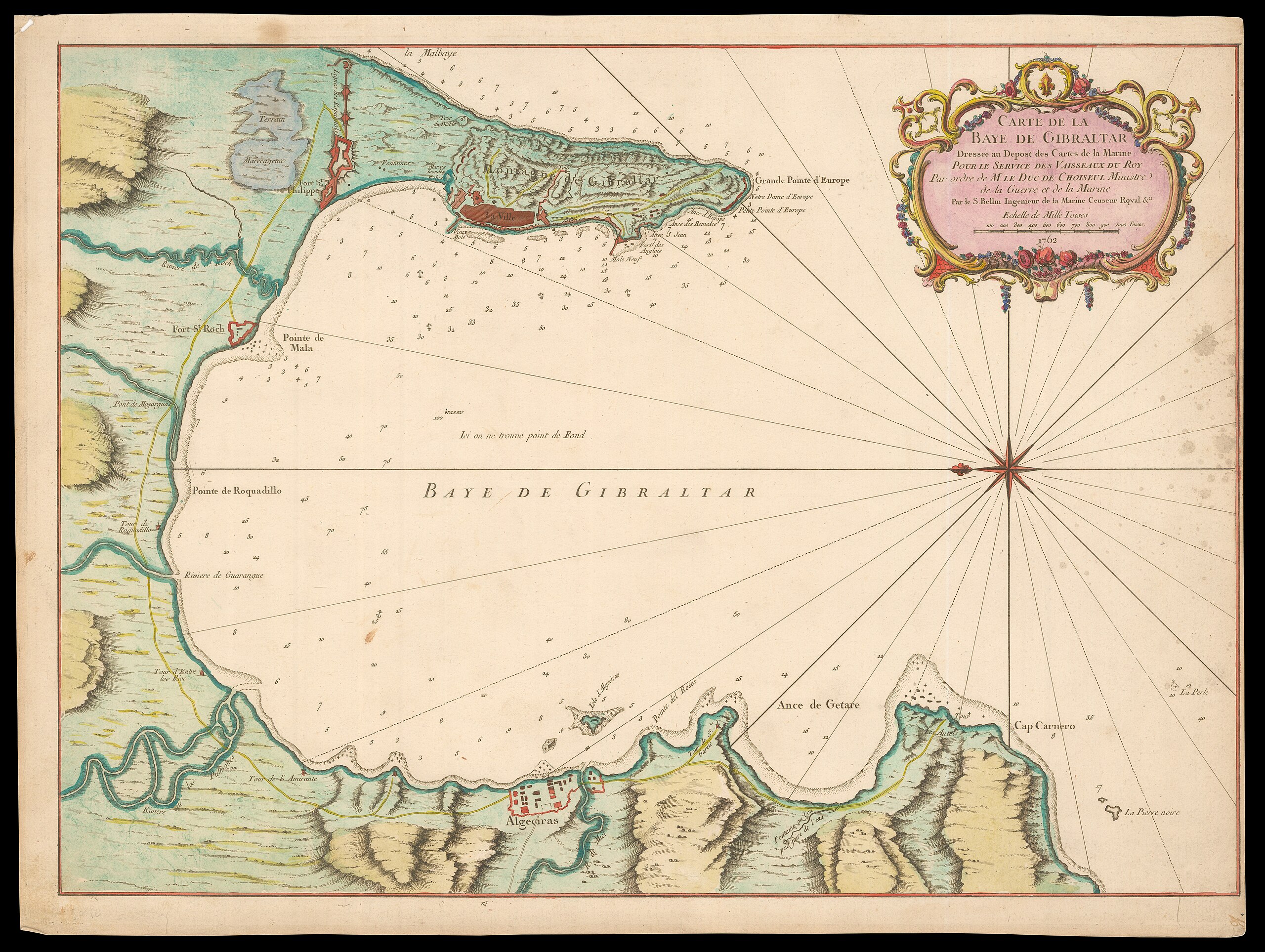
edit| Jacques-Nicolas Bellin: Carte de la baye de Gibraltar
( |
||||||||||||||||||||||||
|---|---|---|---|---|---|---|---|---|---|---|---|---|---|---|---|---|---|---|---|---|---|---|---|---|
| Artist |
|
|||||||||||||||||||||||
| Title |
Carte de la baye de Gibraltar |
|||||||||||||||||||||||
| Description |
Carte de la baye de Gibraltar. Dresseé au depost des cartes de la marine... . Par le S.Bellin. |
|||||||||||||||||||||||
| Language | French | |||||||||||||||||||||||
| Publication date | 1762 | |||||||||||||||||||||||
| Medium | 1 map : col ; | |||||||||||||||||||||||
| Dimensions | height: 418 mm (16.45 in); width: 574 mm (22.59 in) | |||||||||||||||||||||||
| Collection |
|
|||||||||||||||||||||||
| Current location |
|
|||||||||||||||||||||||
| Place of publication | Paris | |||||||||||||||||||||||
| search Merhav catalog | Paris | |||||||||||||||||||||||
| Notes | ||||||||||||||||||||||||
| IE PID | IE13721127 | |||||||||||||||||||||||
| Rosetta filename | FL13721129 | |||||||||||||||||||||||
| NNL item ID (P3959) | 990024706690205171 | |||||||||||||||||||||||
| search Merhav catalog | French, Jacques-Nicolas Bellin | |||||||||||||||||||||||
| Source/Photographer |
|
|||||||||||||||||||||||
| Other versions | ||||||||||||||||||||||||
| Jpg / Tif version |
|
|||||||||||||||||||||||

.jpg)

.jpg&action=edit§ion=1)
Licensing
edit.jpg&action=edit§ion=2)
The copyright situation of this work is theoretically uncertain, because in the country of origin copyright lasts 70 years after the death of the author, and the date of the author's death is unknown. However, the date of creation of the work was over 120 years ago, and it is thus a reasonable assumption that the copyright has expired (see here for the community discussion). Do not use this template if the date of death of the author is known.
| |
| This file has been identified as being free of known restrictions under copyright law, including all related and neighboring rights. | |
File history
Click on a date/time to view the file as it appeared at that time.
| Date/Time | Thumbnail | Dimensions | User | Comment | |
|---|---|---|---|---|---|
| current | 10:41, 1 August 2023 | | 9,733 × 7,325 (94.79 MB) | Geagea (talk | contribs) | pattypan 22.03 |
You cannot overwrite this file.
File usage on Commons
The following 2 pages use this file:
.jpg&oldid=788966822)