File:Jaipur, Jantar Mantar, Brihat Samrat Yantra (9713595658).jpg

Original file (5,184 × 3,456 pixels, file size: 5.34 MB, MIME type: image/jpeg)
Captions
Captions
Summary edit
.jpg&action=edit§ion=1)
| Description |
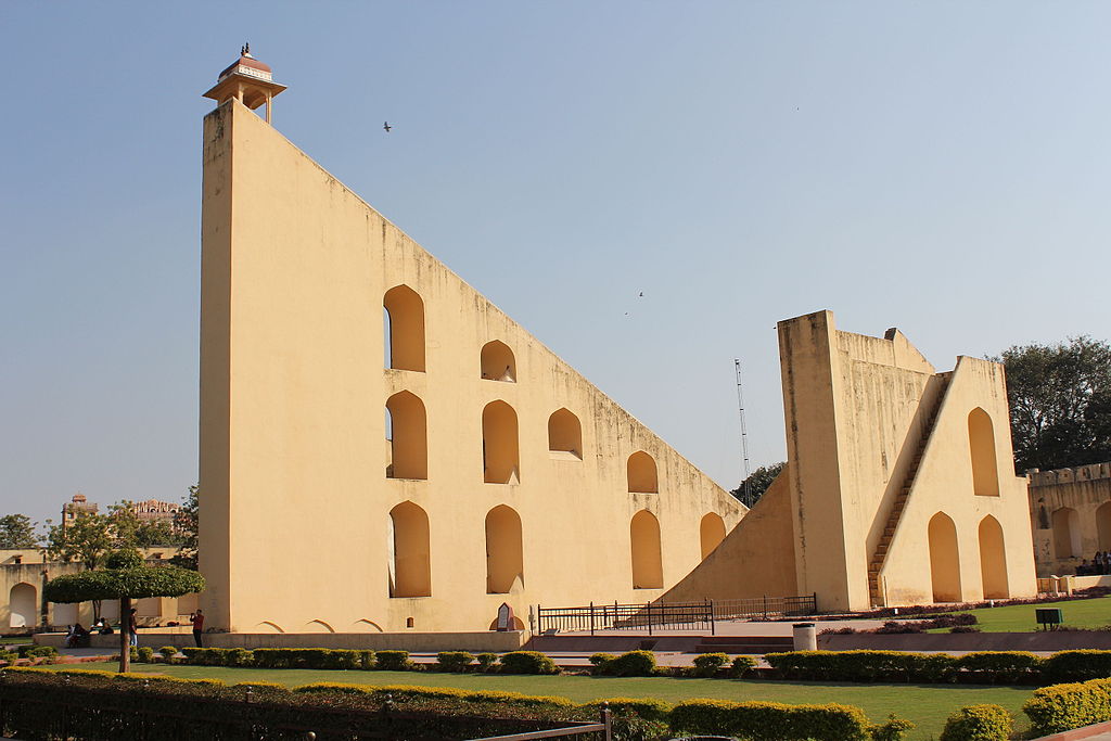
Jaipur, Jantar Mantar, Brihat Samrat Yantra Jaipur is the capital and largest city of the Indian state of Rajasthan in Northern India. It was founded on 18 November 1727 by Maharaja Sawai Jai Singh II, the ruler of Amber, after whom the city is named. The city today has a population of 3.1 million. Jaipur is known as the Pink City of India. The city is unusual among pre-modern Indian cities in the regularity of its streets, and the division of the city into six sectors by broad streets 34 m wide. The urban quarters are further divided by networks of gridded streets. Five quarters wrap around the east, south, and west sides of a central palace quarter, with a sixth quarter immediately to the east. The Palace quarter encloses the Hawa Mahal palace complex, formal gardens, and a small lake. Nahargarh Fort, which was the residence of the King Sawai Jai Singh II, crowns the hill in the northwest corner of the old city. The observatory, Jantar Mantar, is one of the World Heritage Sites. Included on the Golden Triangle tourist circuit, along with Delhi and Agra, Jaipur is an extremely popular tourist destination in Rajasthan and India. The Jantar Mantar is a collection of architectural astronomical instruments, built by Sawai Jai Singh, who was a Rajput king. It is modeled after the one that Jai Singh had built at the Mughal capital of Delhi. He had constructed a total of five such facilities at different locations, including the ones at Delhi and Jaipur. The Jaipur observatory is the largest and best preserved of these. The observatory consists of fourteen major geometric devices for measuring time, predicting eclipses, tracking the location of stars as the earth orbits around the sun, ascertaining the declinations of planets, and determining the celestial altitudes and related ephemerides. Each is a fixed and 'focused' tool. The Samrat Yantra, the largest instruments, is 27 m high, its shadow carefully plotted to tell the time of day. Its face is angled at 27 degrees, the latitude of Jaipur. The Hindu chhatri (small cupola) on top is used as a platform for announcing eclipses and the arrival of monsoons. Built from local stone and marble, each instrument carries an astronomical scale, generally marked on the marble inner lining. Bronze tablets, all extraordinarily accurate, were also employed. (source: en.wikipedia.org/wiki/Jaipur and en.wikipedia.org/wiki/Jantar_Mantar_%28Jaipur%29) |
| Date | |
| Source | Jaipur, Jantar Mantar, Brihat Samrat Yantra |
| Author | Arian Zwegers from Brussels, Belgium |
| Camera location | | View this and other nearby images on: OpenStreetMap |
|---|
.jpg¶ms=026.924722_N_0075.824444_E_globe:Earth_type:camera_source:Flickr_&language=en)
Licensing edit
.jpg&action=edit§ion=2)
- You are free:
- to share – to copy, distribute and transmit the work
- to remix – to adapt the work
- Under the following conditions:
- attribution – You must give appropriate credit, provide a link to the license, and indicate if changes were made. You may do so in any reasonable manner, but not in any way that suggests the licensor endorses you or your use.
| This image was originally posted to Flickr by Arian Zwegers at https://flickr.com/photos/67769030@N07/9713595658. It was reviewed on 8 March 2016 by FlickreviewR and was confirmed to be licensed under the terms of the cc-by-2.0. |
File history
Click on a date/time to view the file as it appeared at that time.
| Date/Time | Thumbnail | Dimensions | User | Comment | |
|---|---|---|---|---|---|
| current | 20:14, 8 March 2016 | | 5,184 × 3,456 (5.34 MB) | Shipjustgotreal (talk | contribs) | Transferred from Flickr via Flickr2Commons |
You cannot overwrite this file.
File usage on Commons
There are no pages that use this file.
File usage on other wikis
The following other wikis use this file:
- Usage on eo.wikipedia.org
.jpg&oldid=853477436)