File:Jakarta districts.png

Size of this preview: 582 × 599 pixels. Other resolutions: 233 × 240 pixels | 466 × 480 pixels | 746 × 768 pixels | 1,169 × 1,204 pixels.
Original file (1,169 × 1,204 pixels, file size: 242 KB, MIME type: image/png)
Captions
Captions
Add a one-line explanation of what this file represents
Summary edit
| Description |
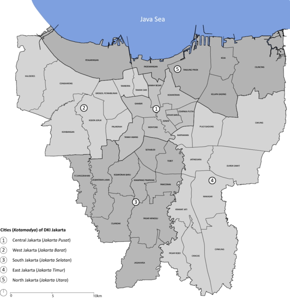
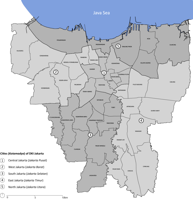
English: Map of City/Kotamadya of Jakarta with its Subdistrict/Kecamatan. The cities are color-coded (in the map) |
| Date | 19 December 2009 (original upload date); 30 January 2010 (last version)) |
| Source |
Own work (Original caption: " I (Rochelimit (talk)) created this work entirely by myself. ") |
| Author | Rochelimit at en.wikipedia |
Licensing edit
Rochelimit at en.wikipedia, the copyright holder of this work, hereby publishes it under the following licenses:
This file is licensed under the Creative Commons Attribution-Share Alike 3.0 Unported license.
Attribution: Rochelimit at en.wikipedia
- You are free:
- to share – to copy, distribute and transmit the work
- to remix – to adapt the work
- Under the following conditions:
- attribution – You must give appropriate credit, provide a link to the license, and indicate if changes were made. You may do so in any reasonable manner, but not in any way that suggests the licensor endorses you or your use.
- share alike – If you remix, transform, or build upon the material, you must distribute your contributions under the same or compatible license as the original.

|
Permission is granted to copy, distribute and/or modify this document under the terms of the GNU Free Documentation License, Version 1.2 or any later version published by the Free Software Foundation; with no Invariant Sections, no Front-Cover Texts, and no Back-Cover Texts. A copy of the license is included in the section entitled GNU Free Documentation License. |
You may select the license of your choice.
Original upload log edit
The original description page was here. All following user names refer to en.wikipedia.
- 2010-01-30 14:43 Rochelimit 1169×1204× (200432 bytes) Correct errors in names, and in the coast line of outside Jakarta
- 2009-12-19 03:57 Rochelimit 1169×1221× (386041 bytes) {{Information |Description = Map of City/Kotamadya of Jakarta with its Subdistrict/Kecamatan |Source = I (~~~) created this work entirely by myself. |Date = ~~~~~ |Author = ~~~ |other_versions = none }}
File history
Click on a date/time to view the file as it appeared at that time.
| Date/Time | Thumbnail | Dimensions | User | Comment | |
|---|---|---|---|---|---|
| current | 09:38, 24 March 2023 | | 1,169 × 1,204 (242 KB) | Amadhannn (talk | contribs) | recoloring the edges |
| 19:36, 27 November 2021 |  | 1,169 × 1,204 (274 KB) | Adam37 (talk | contribs) | Sharpened. Remains work of 2009-12-19 03:57:07 by Rochelimit | |
| 13:29, 14 December 2011 |  | 1,169 × 1,204 (196 KB) | OgreBot (talk | contribs) | (BOT): Reverting to most recent version before archival | |
| 13:29, 14 December 2011 |  | 1,169 × 1,221 (377 KB) | OgreBot (talk | contribs) | (BOT): Uploading old version of file from en.wikipedia; originally uploaded on 2009-12-19 03:57:07 by Rochelimit | |
| 18:46, 10 December 2011 |  | 1,169 × 1,204 (196 KB) | Nk (talk | contribs) | {{Information |Description={{en|Map of City/Kotamadya of Jakarta with its Subdistrict/Kecamatan. The cities are color-coded (in the map)}} |Source=Transferred from [http://en.wikipedia.org en.wikipedia]<br/> (Original text : ''I ([[:en:User:Rochelimit|Roc |
You cannot overwrite this file.
File usage on Commons
The following page uses this file:
- File:Jakarta subdistrict.png (file redirect)
File usage on other wikis
The following other wikis use this file:
- Usage on ar.wikipedia.org
- Usage on arz.wikipedia.org
- Usage on ban.wikipedia.org
- Usage on bg.wikipedia.org
- Usage on bjn.wikipedia.org
- Usage on ceb.wikipedia.org
- Usage on de.wikipedia.org
- Usage on en.wikipedia.org
- Cilandak
- Istiqlal Mosque, Jakarta
- May 1998 riots of Indonesia
- Istana Negara (Jakarta)
- Jakarta Kota railway station
- Ratu Plaza
- Gambir railway station
- Mal Kelapa Gading
- Duren Sawit
- Cengkareng
- Pancoran, South Jakarta
- Kembangan, Jakarta
- Jakarta Bay
- Johar Baru
- Grogol Petamburan
- Kalideres
- Kebon Jeruk
- Palmerah
- Taman Sari, Jakarta
- Tambora, Jakarta
- Duri Kosambi, Cengkareng
- Grogol
- Tomang
- Wijaya Kusuma
- Kalideres, Kalideres
- Kamal, Kalideres
- Pegadungan
- Semanan
- Tegal Alur
- Duri Kepa
- Cakung
- Ciracas
- Kramat Jati, East Jakarta
- Makasar, Jakarta
- Matraman
- Pasar Rebo
- Pulo Gadung
- Kebayoran Lama
- Pesanggrahan
- Pademangan
- Halim Perdanakusuma International Airport
View more global usage of this file.