File:Jane Austen Map.png
No higher resolution available.
Jane_Austen_Map.png (433 × 317 pixels, file size: 13 KB, MIME type: image/png)
Captions
Captions
Add a one-line explanation of what this file represents
Summary edit
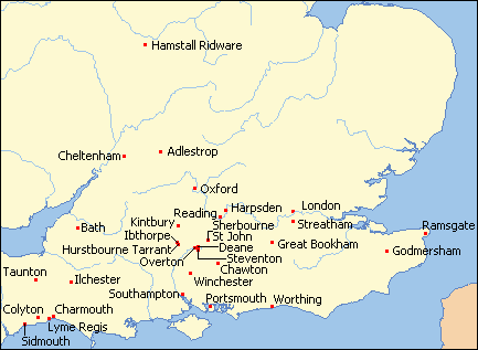
| Description | Map of Britain from Online Map Creation, colored and cropped by Ruhrfisch, red dots are the thirty places where Jane Austen lived or visited, added by Ruhrfisch |
| Date | |
| Source | Online Map Creation, (which uses GMT,[1] an open source software licensed under GNU GPL[2]) |
| Author | Online Map Creation, Ruhrfisch |
| Permission (Reusing this file) |
GFDL |

|
This map image could be re-created using vector graphics as an SVG file. This has several advantages; see Commons:Media for cleanup for more information. If an SVG form of this image is available, please upload it and afterwards replace this template with
{{vector version available|new image name}}.
It is recommended to name the SVG file “Jane Austen Map.svg”—then the template Vector version available (or Vva) does not need the new image name parameter. |
Licensing edit
I, the copyright holder of this work, hereby publish it under the following license:

|
Permission is granted to copy, distribute and/or modify this document under the terms of the GNU Free Documentation License, Version 1.2 or any later version published by the Free Software Foundation; with no Invariant Sections, no Front-Cover Texts, and no Back-Cover Texts. A copy of the license is included in the section entitled GNU Free Documentation License. |
| This file is licensed under the Creative Commons Attribution-Share Alike 3.0 Unported license. | ||
| ||
| This licensing tag was added to this file as part of the GFDL licensing update. |
File history
Click on a date/time to view the file as it appeared at that time.
| Date/Time | Thumbnail | Dimensions | User | Comment | |
|---|---|---|---|---|---|
| current | 17:42, 8 March 2008 | | 433 × 317 (13 KB) | Ruhrfisch (talk | contribs) | Add labels to base map (as they did not show up consistently when wikilinked) |
| 03:36, 7 March 2008 |  | 433 × 317 (10 KB) | Ruhrfisch (talk | contribs) | Update map to smaller version with dots to assist overlay placement, other info the same | |
| 04:40, 11 February 2008 |  | 433 × 722 (28 KB) | Ruhrfisch (talk | contribs) | {{Information |Description= Map of Britain from [http://www.aquarius.geomar.de/cgi-bin/map-cgi.pl Online Map Creation], colored and cropped by Ruhrfisch |Date= December 2007 |Author= Online Map Creation, Ruhrfisch |Permission= GFDL |oth |
You cannot overwrite this file.
File usage on Commons
There are no pages that use this file.
File usage on other wikis
The following other wikis use this file:
- Usage on ar.wikipedia.org
- Usage on avk.wikipedia.org
- Usage on bg.wikipedia.org
- Usage on en.wikipedia.org
- Usage on es.wikipedia.org
- Usage on fr.wikipedia.org