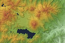
File:Japan-Tochigi, Nikko mountain range, lakes and rivers relief map 2.jpg

Size of this preview: 431 × 600 pixels. Other resolutions: 172 × 240 pixels | 345 × 480 pixels | 1,000 × 1,392 pixels.
Original file (1,000 × 1,392 pixels, file size: 501 KB, MIME type: image/jpeg)
File information
Structured data
Captions
Captions
Add a one-line explanation of what this file represents
Summary
edit| DescriptionJapan-Tochigi, Nikko mountain range, lakes and rivers relief map 2.jpg |
English: Relief map of Nantai Volcano & Lake Chuzenji, Tochigi Prefecture, Kantō region, Honshu, Japan. Français : Japon : carte en relief des sommets des monts Nikkō, du lac Chūzenji et de la rivière Daiya à Nikkō (préfecture de Tochigi). |
| Date | |
| Source | Original version |
| Author | ContributorQ |
| Other versions |
 |
Licensing
editI, the copyright holder of this work, hereby publish it under the following license:
This file is licensed under the Creative Commons Attribution-Share Alike 4.0 International license.
- You are free:
- to share – to copy, distribute and transmit the work
- to remix – to adapt the work
- Under the following conditions:
- attribution – You must give appropriate credit, provide a link to the license, and indicate if changes were made. You may do so in any reasonable manner, but not in any way that suggests the licensor endorses you or your use.
- share alike – If you remix, transform, or build upon the material, you must distribute your contributions under the same or compatible license as the original.
| Annotations InfoField | This image is annotated: View the annotations at Commons |
334
652
211
148
1000
1392
Mount Nantai
37
327
357
499
1000
1392
Chūzenji lake
580
754
111
128
1000
1392
Mount Ōmanago
673
798
100
84
1000
1392
Mount Komanago
722
900
86
72
1000
1392
Mount Taishaku
722
954
58
60
1000
1392
Mount Nyōhō
754
1083
63
79
1000
1392
Mount Akanagi
735
659
88
90
1000
1392
Mount Tarō
747
557
107
84
1000
1392
Mount Sannōboshi
615
77
79
74
1000
1392
Mount Nikkō-Shirane
617
336
102
88
1000
1392
Yu lake
218
200
86
70
1000
1392
Sai lake
2
633
65
70
1000
1392
Mount Hangetsu
399
422
146
114
1000
1392
Yu river
360
371
241
234
1000
1392
Senjōgahara
448
1218
142
65
1000
1392
Inari river
216
1128
160
262
1000
1392
Daiya river
195
775
70
74
1000
1392
Kegon falls
183
879
84
202
1000
1392
Daiya river
File history
Click on a date/time to view the file as it appeared at that time.
| Date/Time | Thumbnail | Dimensions | User | Comment | |
|---|---|---|---|---|---|
| current | 21:27, 23 April 2017 |  | 1,000 × 1,392 (501 KB) | ContributorQ (talk | contribs) | User created page with UploadWizard |
You cannot overwrite this file.
File usage on Commons
There are no pages that use this file.