File:Jeonju-wansan-gu-map.png

Size of this preview: 703 × 600 pixels. Other resolutions: 281 × 240 pixels | 563 × 480 pixels | 900 × 768 pixels | 1,201 × 1,024 pixels | 2,401 × 2,048 pixels | 3,000 × 2,559 pixels.
Original file (3,000 × 2,559 pixels, file size: 961 KB, MIME type: image/png)
Captions
Captions
Add a one-line explanation of what this file represents
Summary
edit
| Description |
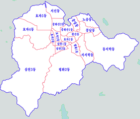
한국어: 전주시 완산구
English: Detail map of Wansan-gu, Jeonju
中文(繁體):全羅北道 全州市 完山區
日本語: 全羅北道 全州市 完山区 |
| Date | |
| Source | Own work |
| Author | Asfreeas |
| Permission (Reusing this file) |
Public Domain |
| Other versions | http://ko.wikipedia.org/wiki/%ED%8C%8C%EC%9D%BC:Jeonju-map.png |
Licensing
edit
I, the copyright holder of this work, hereby publish it under the following license:
| This file is made available under the Creative Commons CC0 1.0 Universal Public Domain Dedication. | |
| The person who associated a work with this deed has dedicated the work to the public domain by waiving all of their rights to the work worldwide under copyright law, including all related and neighboring rights, to the extent allowed by law. You can copy, modify, distribute and perform the work, even for commercial purposes, all without asking permission.
|
File history
Click on a date/time to view the file as it appeared at that time.
| Date/Time | Thumbnail | Dimensions | User | Comment | |
|---|---|---|---|---|---|
| current | 12:10, 7 August 2019 | | 3,000 × 2,559 (961 KB) | Gloyacks (talk | contribs) | 지명수정 |
| 19:28, 8 July 2012 |  | 1,602 × 1,276 (304 KB) | Asfreeas (talk | contribs) |
You cannot overwrite this file.
File usage on Commons
There are no pages that use this file.
File usage on other wikis
The following other wikis use this file: