File:Jerusalem and places adjacent (FL45582638 3922578).jpg

Size of this preview: 433 × 599 pixels. Other resolutions: 173 × 240 pixels | 347 × 480 pixels | 555 × 768 pixels | 1,194 × 1,652 pixels.
Original file (1,194 × 1,652 pixels, file size: 483 KB, MIME type: image/jpeg)
Captions
Captions
Add a one-line explanation of what this file represents
Summary
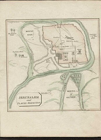
edit| Jerusalem and places adjacent
( |
||||||||||||||||||||||||
|---|---|---|---|---|---|---|---|---|---|---|---|---|---|---|---|---|---|---|---|---|---|---|---|---|
| Title |
Jerusalem and places adjacent |
|||||||||||||||||||||||
| Publisher |
American Sunday School Union |
|||||||||||||||||||||||
| Description |
Jerusalem and places adjacent.. |
|||||||||||||||||||||||
| Language | English | |||||||||||||||||||||||
| Publication date | 1827 | |||||||||||||||||||||||
| Medium | 1 online resource (1 map). | |||||||||||||||||||||||
| Collection |
|
|||||||||||||||||||||||
| Current location |
|
|||||||||||||||||||||||
| Place of publication | Philadelphia | |||||||||||||||||||||||
| search Merhav catalog | Philadelphia | |||||||||||||||||||||||
| Notes | Digital image of the original in Amir Cahanovitc Collection, Israel. ACC 1920-6.; Digital image received from donor.; From: Bible atlas containing nine maps with explanations illustrative of scripture history designed for Bible classes and Sabbath schools. | |||||||||||||||||||||||
| IE PID | IE45582635 | |||||||||||||||||||||||
| Rosetta filename | FL45582638 | |||||||||||||||||||||||
| NNL item ID (P3959) | 990039225780205171 | |||||||||||||||||||||||
| search Merhav catalog | English | |||||||||||||||||||||||
| search Merhav catalog | American Sunday School Union | |||||||||||||||||||||||
| Source/Photographer |
|
|||||||||||||||||||||||
| Other versions | ||||||||||||||||||||||||
| Jpg / Tif version |
|
|||||||||||||||||||||||

.jpg)

.jpg&action=edit§ion=1)
Licensing
edit.jpg&action=edit§ion=2)
The copyright situation of this work is theoretically uncertain, because in the country of origin copyright lasts 70 years after the death of the author, and the date of the author's death is unknown. However, the date of creation of the work was over 120 years ago, and it is thus a reasonable assumption that the copyright has expired (see here for the community discussion). Do not use this template if the date of death of the author is known.
| |
| This file has been identified as being free of known restrictions under copyright law, including all related and neighboring rights. | |
File history
Click on a date/time to view the file as it appeared at that time.
| Date/Time | Thumbnail | Dimensions | User | Comment | |
|---|---|---|---|---|---|
| current | 19:49, 5 September 2023 | | 1,194 × 1,652 (483 KB) | Geagea (talk | contribs) | pattypan 22.03 |
You cannot overwrite this file.
File usage on Commons
The following page uses this file:
.jpg&oldid=798734254)