File:Jerusalem oldcity English.jpg
Size of this preview: 664 × 599 pixels. Other resolutions: 266 × 240 pixels | 532 × 480 pixels | 923 × 833 pixels.
Original file (923 × 833 pixels, file size: 257 KB, MIME type: image/jpeg)
Captions
Captions
Add a one-line explanation of what this file represents
Summary
edit| Description |
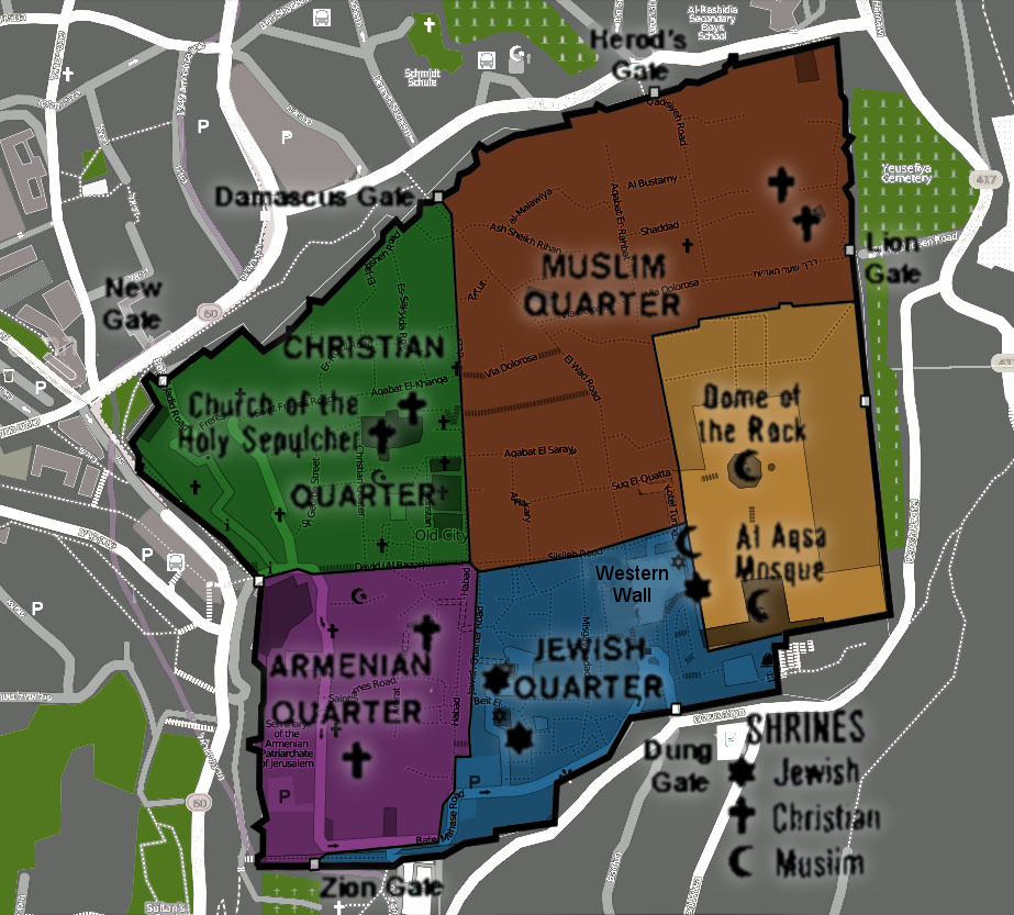
English: A diagram of the quarters of the old city of Jerusalem - titles in hebrew עברית: רובעי העיר העתיקה - ירושלים English: Map of Old Jerusalem Geographic limits of the map: * N: 31.78466° * S: 31.77045° * W: 35.22369° * E: 35.23949°
This file is licensed under the Creative Commons Attribution-Share Alike 2.0 Generic license.
English: Map of Old Jerusalem Geographic limits of the map: * N: 31.78466° * S: 31.77045° * W: 35.22369° * E: 35.23949°
Map of Jerusalem's Old CityThis file is licensed under the Creative Commons Attribution-Share Alike 2.0 Generic license.
|
| Date |
14 March 2005 (original upload date) English: A diagram of the quarters of the old city of Jerusalem - titles in hebrew עברית: רובעי העיר העתיקה - ירושלים |
| Source |
This file was derived from: |
| Author |
|

| This is a retouched picture, which means that it has been digitally altered from its original version. Modifications: Merged maps + added English captions. The original can be viewed here: Jerusalem oldcity hebrew.svg:
|
Licensing
edit
This file is licensed under the Creative Commons Attribution-Share Alike 3.0 Unported license.
- You are free:
- to share – to copy, distribute and transmit the work
- to remix – to adapt the work
- Under the following conditions:
- attribution – You must give appropriate credit, provide a link to the license, and indicate if changes were made. You may do so in any reasonable manner, but not in any way that suggests the licensor endorses you or your use.
- share alike – If you remix, transform, or build upon the material, you must distribute your contributions under the same or compatible license as the original.
Original upload log
edit
This image is a derivative work of the following images:
- File:Jerusalem_oldcity_Hebrew.jpg licensed with Cc-by-sa-2.0, Cc-by-sa-3.0
- 2013-06-02T02:30:55Z ויקיג'אנקי 923x833 (213289 Bytes) == {{int:filedesc}} == {{Information |Description={{en|A diagram of the quarters of the old city of Jerusalem - titles in hebrew}}{{he|רובעי העיר העתיקה - ירושלים}} {{en|1=Map of Old Jerusalem Geographic
- File:Location_map_Jerusalem.png licensed with Cc-by-sa-2.0
- 2011-02-28T21:05:24Z Blofeld Dr. 923x977 (400415 Bytes) {{Information |Description ={{en|1=o}} |Source =o |Author =o |Date =o |Permission = |other_versions = }}
- File:Map_jerusalem_oldcity.png licensed with Cc-by-sa-3.0
- 2012-11-30T20:51:02Z MGA73bot2 400x388 (114683 Bytes) {{BotMoveToCommons|en.oldwikivoyage|year={{subst:CURRENTYEAR}}|month={{subst:CURRENTMONTHNAME}}|day={{subst:CURRENTDAY}}}} == {{int:filedesc}} == {{Information |description=Map of Jerusalem's Old City -- by CIA (PD) with edit
- File:Jerusalem_oldcity_hebrew.svg licensed with PD-self
- 2007-09-11T05:40:40Z Cumulus 710x520 (15604 Bytes)
- 2007-09-11T05:39:40Z Cumulus 710x520 (15612 Bytes) {{Information |Description={en|A diagram of the quarters of the old city of Jerusalem - titles in hebrew}{he|רובעי העיר העתיקה - ירושלים} |Source=self-made, based on [[|:en:image:OldCityMap.png]] |Date=2
Uploaded with derivativeFX
File history
Click on a date/time to view the file as it appeared at that time.
| Date/Time | Thumbnail | Dimensions | User | Comment | |
|---|---|---|---|---|---|
| current | 23:05, 31 December 2017 | | 923 × 833 (257 KB) | Ar2332 (talk | contribs) | Wailing Wall -> Western Wall |
| 15:59, 2 June 2013 |  | 923 × 833 (216 KB) | ויקיג'אנקי (talk | contribs) | == {{int:filedesc}} == {{Information |Description={{en|A diagram of the quarters of the old city of Jerusalem - titles in hebrew}}{{he|רובעי העיר העתיקה - ירושלים}} {{en|1=Map of Old Jerusalem Geographic limits of the map: * N: 31... |
You cannot overwrite this file.
File usage on Commons
The following page uses this file:
File usage on other wikis
The following other wikis use this file:
- Usage on el.wikivoyage.org
- Usage on en.wikipedia.org
- Usage on en.wikibooks.org
- Usage on en.wikivoyage.org
- Usage on fi.wikipedia.org
- Usage on it.wikivoyage.org
- Usage on sv.wikipedia.org