File:Jiasian Jhenhai Military Cemetery(jia xian zhen hai jun mu), Kaohsiung City, Taiwan, by Joewuheritage 5.jpg

Size of this preview: 800 × 600 pixels. Other resolutions: 320 × 240 pixels | 640 × 480 pixels | 1,024 × 768 pixels | 1,280 × 960 pixels | 2,560 × 1,920 pixels | 8,064 × 6,048 pixels.
Original file (8,064 × 6,048 pixels, file size: 43.89 MB, MIME type: image/jpeg)
Captions
Captions
Add a one-line explanation of what this file represents
Summary
edit
| Description |
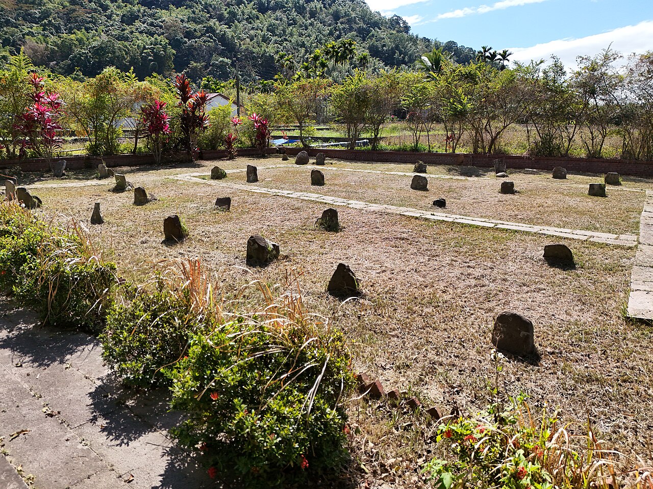
中文(繁體):光緒12年(1886)間,駐防臺灣府城(即今臺南市)的鎮海軍提督楊金龍、臺灣鎮總兵章高元,奉巡撫劉銘傳之命率領所屬軍隊,以嘉義大埔為起點,向東開闢經甲仙埔、荖濃、寶來、關山,越八潼關(約今啞口)後,通抵大陂(今臺東池上)的橫貫道路(約今南橫公路路線)。是年3月,楊金龍、章高元分別率領鎮海中軍的前營和正副兩營等展開拓建工程,在今甲仙區小林里五里埔設置營壘駐防,兼作工寮。後因夏季炎熱,內山瘴氣過重,軍士兵多數水土不服,病歿者百餘人,後葬於營壘東側,現存者有85座之多,即為鎮海軍墓。
鎮海軍墓的墓碑有銘文書寫者不多,僅27座,書寫方式各異,且銘文由尖物刻出,簡樸有力。由銘文可知這群官兵非同姓之家族兵,並且大多來自於湖南,墓群多為鎮海中軍前營之官兵。立碑時間多為光緒12年(1886)5月至9月,推測官兵疑似死於南臺灣酷暑下各種橫生的疾病。官兵袍澤相互照顧,為客死異鄉者草葬於營壘之側。墓碑石材多取自附近的板岩、砂岩。 墓碑軍籍多為鎮海中軍前營,亦有鎮海中軍右營者。前營之兵則有後哨、左哨之分,另有後哨第八隊之支隊名。由於墓葬區緊鄰鎮海中軍前營駐地營壘,故墓群可能屬於鎮海中軍前營之兵,但亦有可能屬章高元所領之部,故古蹟名為「鎮海軍墓」,以避專奪。 |
| Date | |
| Source | Own work |
| Author | Joewuheritage |
| Camera location | | View this and other nearby images on: OpenStreetMap |
|---|
Licensing
edit
I, the copyright holder of this work, hereby publish it under the following license:
This file is licensed under the Creative Commons Attribution-Share Alike 4.0 International license.
- You are free:
- to share – to copy, distribute and transmit the work
- to remix – to adapt the work
- Under the following conditions:
- attribution – You must give appropriate credit, provide a link to the license, and indicate if changes were made. You may do so in any reasonable manner, but not in any way that suggests the licensor endorses you or your use.
- share alike – If you remix, transform, or build upon the material, you must distribute your contributions under the same or compatible license as the original.
File history
Click on a date/time to view the file as it appeared at that time.
| Date/Time | Thumbnail | Dimensions | User | Comment | |
|---|---|---|---|---|---|
| current | 08:24, 15 March 2024 | | 8,064 × 6,048 (43.89 MB) | Joewuheritage (talk | contribs) | Uploaded own work with UploadWizard |
You cannot overwrite this file.
File usage on Commons
There are no pages that use this file.
,_Kaohsiung_City,_Taiwan,_by_Joewuheritage_5.jpg&oldid=874002620)