File:John J. Suhr House, Langdon Street, State-Langdon-Lakeshore, Madison, WI - 52780269521.jpg
Size of this preview: 738 × 600 pixels. Other resolutions: 296 × 240 pixels | 591 × 480 pixels | 945 × 768 pixels | 1,261 × 1,024 pixels | 2,521 × 2,048 pixels | 3,716 × 3,019 pixels.
Original file (3,716 × 3,019 pixels, file size: 4.33 MB, MIME type: image/jpeg)
Captions
Captions
Add a one-line explanation of what this file represents
Summary
edit
| Description |
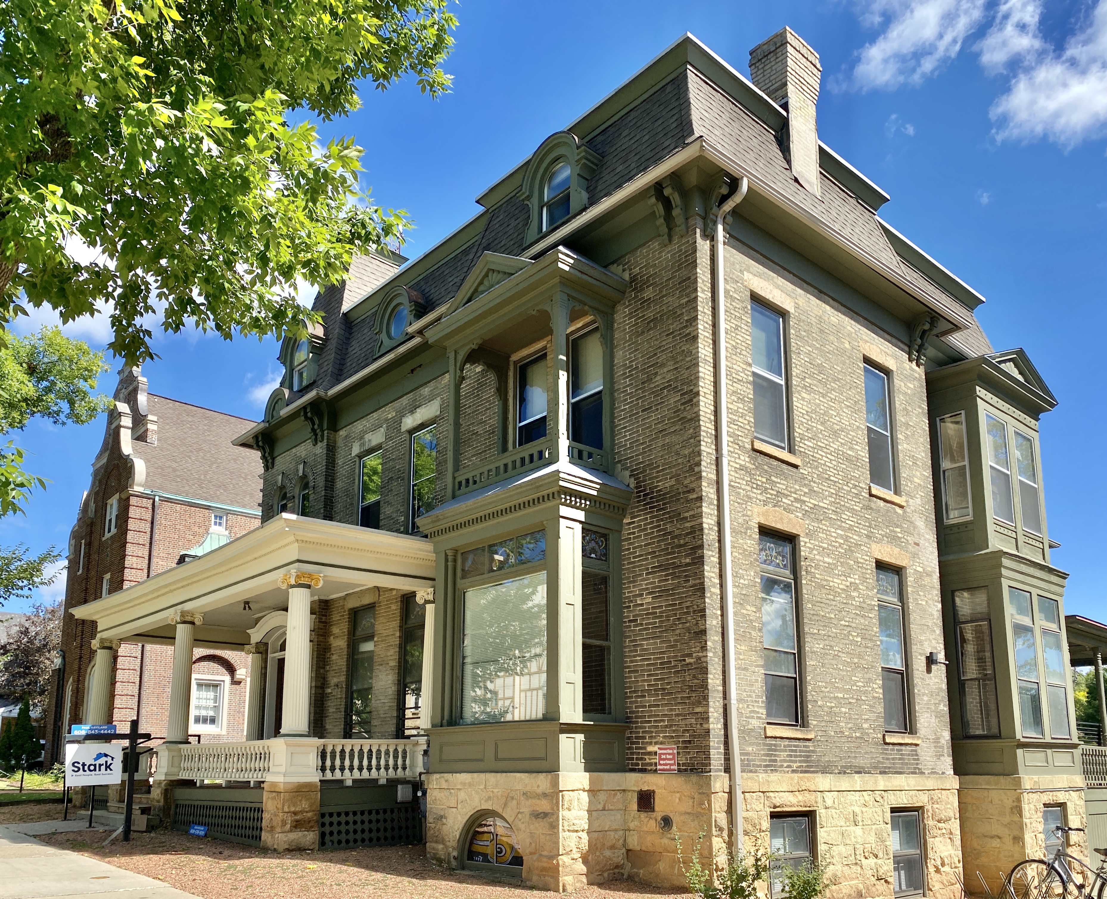
English: Built in 1886, this Second Empire-style house was designed by John Nader for John J. Suhr, and was later renovated in 1902, adding the current front porch and other elements. The house is clad in brown brick with a mansard roof, paired brackets at the eaves, a tall roof over the front entrance bay with iron cresting at the top, dormers with vaulted roofs, some of which contain circular oxeye windows, one-over-one vinyl replacement windows, stained glass transoms on the first floor, a one-story bay window with a covered balcony porch above on the front facade, a rusticated stone base, a front door with an arched transom and decorative surround featuring ionic engaged columns, a front porch with a low-pitch hipped roof, fluted ionic columns, a decorative balustrade, and an open stone pier foundation, a two-story bay window on the side facade, and two rear porches with hipped roofs. The house was listed on the National Register of Historic Places in 1982, and is a contributing structure in the Langdon Street Historic District, listed on the National Register of Historic Places in 1986. |
| Date | |
| Source | https://www.flickr.com/photos/59081381@N03/52780269521/ |
| Author | w_lemay |
| Camera location | | View this and other nearby images on: OpenStreetMap |
|---|
Licensing
edit
This file is licensed under the Creative Commons Attribution-Share Alike 2.0 Generic license.
- You are free:
- to share – to copy, distribute and transmit the work
- to remix – to adapt the work
- Under the following conditions:
- attribution – You must give appropriate credit, provide a link to the license, and indicate if changes were made. You may do so in any reasonable manner, but not in any way that suggests the licensor endorses you or your use.
- share alike – If you remix, transform, or build upon the material, you must distribute your contributions under the same or compatible license as the original.
| This image was originally posted to Flickr by w_lemay at https://flickr.com/photos/59081381@N03/52780269521. It was reviewed on 1 April 2023 by FlickreviewR 2 and was confirmed to be licensed under the terms of the cc-by-sa-2.0. |
File history
Click on a date/time to view the file as it appeared at that time.
| Date/Time | Thumbnail | Dimensions | User | Comment | |
|---|---|---|---|---|---|
| current | 08:07, 1 April 2023 | | 3,716 × 3,019 (4.33 MB) | Ser Amantio di Nicolao (talk | contribs) | Uploaded a work by w_lemay from https://www.flickr.com/photos/59081381@N03/52780269521/ with UploadWizard |
You cannot overwrite this file.
File usage on Commons
There are no pages that use this file.